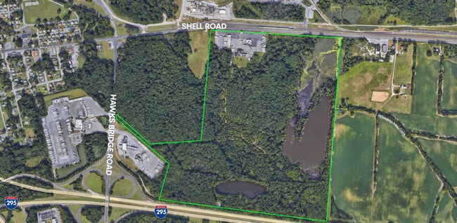
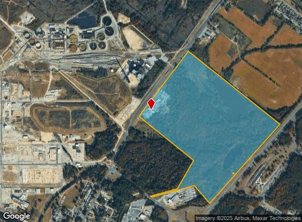
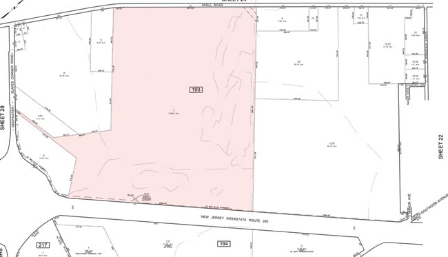
Property Record
455 Shell Rd, Penns Grove, NJ 08069
This Property Is For Sale
NEARBY LISTINGS FOR SALE OR LEASE
Property Detail
455 Shell Rd
Philadelphia-Camden-Wilmington, PA-NJ-DE-MD
ADDITIONAL LOTS: DEEPWATER DINER
02-00193-0000-00007
Salem
Truckterminal
New Jersey
AE
7
34033C0053C
139.82 AC
2024
Salem County
2025
Philadelphia
020600
DEMOGRAPHICS near 455 Shell Rd
1 Mile
3 Mile
5 Mile
2024 Total Population
714
14,920
60,580
2029 Population
721
15,133
61,755
Pop Growth 2024-2029
+ 0.98%
+ 1.43%
+ 1.94%
Average Age
45
41
40
2024 Total Households
282
5,865
22,927
HH Growth 2024-2029
+ 1.06%
+ 1.33%
+ 1.92%
Median Household Inc
$72,255
$67,292
$57,292
Avg Household Size
2.40
2.50
2.50
2024 Avg HH Vehicles
2.00
2.00
2.00
Median Home Value
$186,057
$158,353
$164,673
Median Year Built
1955
1957
1958
Nearby Places
Map Layers
Map Styles
 Street
 Aerial
- Restaurants
- Banks
- Shops
- Fitness
- Groceries
PUBLIC TRANSPORTATION
COMMUTER RAIL
Wilmington (R2 - Southeastern Pennsylvania Transportation Authority Regional Rail (SEPTA Regional Rail))
DRIVE
WALK
Distance
Wilmington (R2 - Southeastern Pennsylvania Transportation Authority Regional Rail (SEPTA Regional Rail))
15 min
7.5 mi
AIRPORT
Philadelphia International
DRIVE
WALK
Distance
Philadelphia International
37 min
23.7 mi
Freight Ports
Port of Wilmington, RI
DRIVE
WALK
Distance
Port of Wilmington, RI
15 min
7.4 mi
Nearby Properties
Address
Land Use
TOTAL SIZE
Lot Size
Zoning
Address
Land Use
TOTAL SIZE
Lot Size
Zoning
118.77 AC
GC
Address
Land Use
TOTAL SIZE
Lot Size
Zoning
412.70 AC
06
Address
Land Use
TOTAL SIZE
Lot Size
Zoning
150.60 AC
AG
Address
Land Use
TOTAL SIZE
Lot Size
Zoning
47.91 AC
IC
Address
Land Use
TOTAL SIZE
Lot Size
Zoning
Address
Land Use
TOTAL SIZE
Lot Size
Zoning
10.75 AC
LC
Address
Land Use
TOTAL SIZE
Lot Size
Zoning
118.77 AC
GC
Address
Land Use
TOTAL SIZE
Lot Size
Zoning
29.05 AC
GC
Address
Land Use
TOTAL SIZE
Lot Size
Zoning
23,402 SF
44.89 AC
LR
Address
Land Use
TOTAL SIZE
Lot Size
Zoning
26.64 AC
GI
Address
Land Use
TOTAL SIZE
Lot Size
Zoning
150.60 AC
AG
Address
Land Use
TOTAL SIZE
Lot Size
Zoning
47.91 AC
IC
Address
Land Use
TOTAL SIZE
Lot Size
Zoning
10.28 AC
IC
Address
Land Use
TOTAL SIZE
Lot Size
Zoning
1,650 SF
26M-2
Address
Land Use
TOTAL SIZE
Lot Size
Zoning
29.05 AC
GC
Address
Land Use
TOTAL SIZE
Lot Size
Zoning
1,133.55 AC
GI
Address
Land Use
TOTAL SIZE
Lot Size
Zoning
11.76 AC
GC
Address
Land Use
TOTAL SIZE
Lot Size
Zoning
2,016 SF
1.44 AC
02
Address
Land Use
TOTAL SIZE
Lot Size
Zoning
Address
Land Use
TOTAL SIZE
Lot Size
Zoning
31.77 AC
GC
Address
Land Use
TOTAL SIZE
Lot Size
Zoning
19,576 SF
5.70 AC
Address
Land Use
TOTAL SIZE
Lot Size
Zoning
61,928 SF
128.88 AC
HI
Address
Land Use
TOTAL SIZE
Lot Size
Zoning
Address
Land Use
TOTAL SIZE
Lot Size
Zoning
25,268 SF
5 AC
LR
Address
Land Use
TOTAL SIZE
Lot Size
Zoning
1,260 SF
3.39 AC
02
Address
Land Use
TOTAL SIZE
Lot Size
Zoning
9,636 SF
10.97 AC
GC
Address
Land Use
TOTAL SIZE
Lot Size
Zoning
1,800 SF
26.62 AC
26M-2
Address
Land Use
TOTAL SIZE
Lot Size
Zoning
Address
Land Use
TOTAL SIZE
Lot Size
Zoning
12,672 SF
11.10 AC
Address
Land Use
TOTAL SIZE
Lot Size
Zoning
6.03 AC
MHR
The World's #1 Commercial Real Estate Marketplace
Connect with us
© 2025 CoStar Group
The information above has been obtained from sources believed reliable. While we do not doubt its accuracy we have not verified it and make no guarantee, warranty or representation about it. It is your responsibility to independently confirm its accuracy and completeness. Any projections, opinions, assumptions, or estimates used are for example only and do not represent the current or future performance of the property. The value of this transaction to you depends on tax and other factors which should be evaluated by your tax, financial, and legal advisors. You and your advisors should conduct a careful, independent investigation of the property to determine to your satisfaction the suitability of the property for your needs.