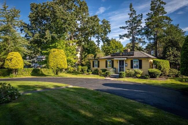
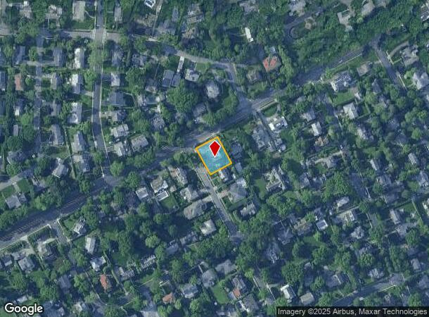
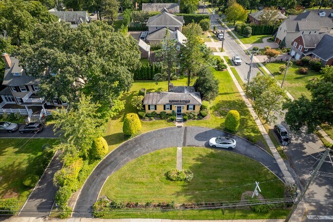
Property Record
4550 Boston Post Rd, Pelham, NY 10803
NEARBY LISTINGS FOR SALE OR LEASE
Property Detail
4550 Boston Post Rd
4405-166-028-00001-000-0056
Map Of Prospect Hill Village
Officebuilding
Westchester
X
New York
36119C0343F
56.000
2025
0.29 AC
2024
Southeast
005500
Westchester/So Connecticut
696 SF
New York-Jersey City-White Plains, NY-NJ
DEMOGRAPHICS near 4550 Boston Post Rd
1 Mile
3 Mile
5 Mile
2024 Total Population
10,907
321,857
867,588
2029 Population
10,503
300,266
810,629
Pop Growth 2024-2029
(3.70%)
(6.71%)
(6.57%)
Average Age
40
41
40
2024 Total Households
3,576
119,901
317,528
HH Growth 2024-2029
(3.78%)
(6.88%)
(6.99%)
Median Household Inc
$172,912
$70,618
$63,572
Avg Household Size
3.00
2.50
2.60
2024 Avg HH Vehicles
2.00
1.00
1.00
Median Home Value
$804,205
$482,252
$554,734
Median Year Built
1947
1953
1949
Nearby Places
- Restaurants
- Banks
- Shops
- Fitness
- Groceries
PUBLIC TRANSPORTATION
COMMUTER RAIL
Pelham Station (New Haven Line - Metro-North Commuter Railroad Company (Metro-North))
DRIVE
WALK
Distance
Pelham Station (New Haven Line - Metro-North Commuter Railroad Company (Metro-North))
3 min
1.7 mi
Mount Vernon East Station (New Haven Line - Metro-North Commuter Railroad Company (Metro-North))
DRIVE
WALK
Distance
Mount Vernon East Station (New Haven Line - Metro-North Commuter Railroad Company (Metro-North))
4 min
2.2 mi
AIRPORT
LaGuardia
DRIVE
WALK
Distance
LaGuardia
22 min
12.7 mi
Westchester County
DRIVE
WALK
Distance
Westchester County
26 min
17.7 mi
John F Kennedy International
DRIVE
WALK
Distance
John F Kennedy International
29 min
20.3 mi
Freight Ports
NY - Red Hook Container Terminal
DRIVE
WALK
Distance
NY - Red Hook Container Terminal
37 min
23.2 mi
SALE & LEASE HISTORY
LISTING DATE
SALE/LEASE

Oct 05, 2021
For Sale
Nov 13, 2022
For Sale
Nearby Properties
Address
Land Use
TOTAL SIZE
Lot Size
Zoning
Address
Land Use
TOTAL SIZE
Lot Size
Zoning
550,000 SF
8.75 AC
M1-1
Address
Land Use
TOTAL SIZE
Lot Size
Zoning
1,132,500 SF
62.44 AC
R6
Address
Land Use
TOTAL SIZE
Lot Size
Zoning
119,980 SF
1,704.55 AC
PARK
Address
Land Use
TOTAL SIZE
Lot Size
Zoning
4,000 SF
19.83 AC
BUS
Address
Land Use
TOTAL SIZE
Lot Size
Zoning
617,567 SF
3.19 AC
R7-1
Address
Land Use
TOTAL SIZE
Lot Size
Zoning
537,208 SF
4.73 AC
C4-3
Address
Land Use
TOTAL SIZE
Lot Size
Zoning
545,388 SF
29.07 AC
C4-3
Address
Land Use
TOTAL SIZE
Lot Size
Zoning
Address
Land Use
TOTAL SIZE
Lot Size
Zoning
Address
Land Use
TOTAL SIZE
Lot Size
Zoning
269,100 SF
1.63 AC
R4
Address
Land Use
TOTAL SIZE
Lot Size
Zoning
165,529 SF
7.05 AC
RA3
Address
Land Use
TOTAL SIZE
Lot Size
Zoning
1,028,976 SF
23.03 AC
R5
Address
Land Use
TOTAL SIZE
Lot Size
Zoning
191,800 SF
13.39 AC
C4-3
Address
Land Use
TOTAL SIZE
Lot Size
Zoning
1,038,034 SF
23.41 AC
R5
Address
Land Use
TOTAL SIZE
Lot Size
Zoning
493,000 SF
3.02 AC
R5
Address
Land Use
TOTAL SIZE
Lot Size
Zoning
12,150 SF
482.09 AC
PARK
Address
Land Use
TOTAL SIZE
Lot Size
Zoning
240,000 SF
6.49 AC
C4-3
Address
Land Use
TOTAL SIZE
Lot Size
Zoning
10,181 SF
30.72 AC
M1-1
Address
Land Use
TOTAL SIZE
Lot Size
Zoning
306,540 SF
11.67 AC
R5
Address
Land Use
TOTAL SIZE
Lot Size
Zoning
560 SF
61.32 AC
PARK
Address
Land Use
TOTAL SIZE
Lot Size
Zoning
336,240 SF
8.45 AC
R5
Address
Land Use
TOTAL SIZE
Lot Size
Zoning
138,305 SF
3.18 AC
R6
Address
Land Use
TOTAL SIZE
Lot Size
Zoning
125,143 SF
2.21 AC
R4
Address
Land Use
TOTAL SIZE
Lot Size
Zoning
219,285 SF
15.51 AC
R4
Address
Land Use
TOTAL SIZE
Lot Size
Zoning
150,613 SF
3.90 AC
R3-2
Address
Land Use
TOTAL SIZE
Lot Size
Zoning
181,092 SF
3.47 AC
R4
Address
Land Use
TOTAL SIZE
Lot Size
Zoning
103,158 SF
1.82 AC
R4
Address
Land Use
TOTAL SIZE
Lot Size
Zoning
141,156 SF
9.37 AC
C4-1
Address
Land Use
TOTAL SIZE
Lot Size
Zoning
188,760 SF
1.95 AC
R6
Address
Land Use
TOTAL SIZE
Lot Size
Zoning
107,473 SF
2.40 AC
R5
The World's #1 Commercial Real Estate Marketplace
Connect with us
© 2025 CoStar Group
The information above has been obtained from sources believed reliable. While we do not doubt its accuracy we have not verified it and make no guarantee, warranty or representation about it. It is your responsibility to independently confirm its accuracy and completeness. Any projections, opinions, assumptions, or estimates used are for example only and do not represent the current or future performance of the property. The value of this transaction to you depends on tax and other factors which should be evaluated by your tax, financial, and legal advisors. You and your advisors should conduct a careful, independent investigation of the property to determine to your satisfaction the suitability of the property for your needs.