Property Record
4550 Kester Mill Rd, Winston Salem, NC 27103
NEARBY LISTINGS FOR SALE OR LEASE
Property Detail
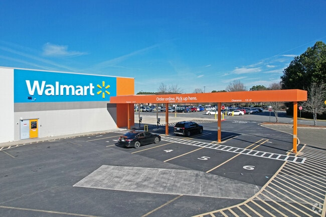
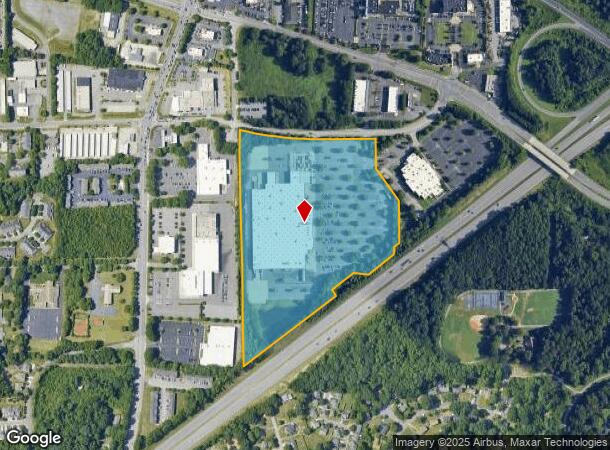
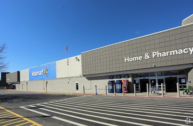
4550 Kester Mill Rd
Winston-Salem, NC
Wal*Mart Supercenter
6804-56-0338
WAL*MART SUPERCENTER LO:450 BL:3904 BU:1
Storebuilding
Forsyth
X
North Carolina
3710680400J
450
2024
23.47 AC
2025
Western Forsyth County
003903
Greensboro/Winston-Salem
257,080 SF
DEMOGRAPHICS near 4550 Kester Mill Rd
1 Mile
3 Mile
5 Mile
2024 Total Population
8,193
53,618
128,312
2029 Population
8,550
55,590
133,334
Pop Growth 2024-2029
+ 4.36%
+ 3.68%
+ 3.91%
Average Age
38
41
41
2024 Total Households
3,770
24,143
56,184
HH Growth 2024-2029
+ 4.40%
+ 3.70%
+ 3.96%
Median Household Inc
$49,107
$64,884
$71,597
Avg Household Size
2.10
2.20
2.20
2024 Avg HH Vehicles
2.00
2.00
2.00
Median Home Value
$210,405
$233,264
$256,996
Median Year Built
1984
1984
1983
Nearby Places
Map Layers
Map Styles
 Street
 Aerial
- Restaurants
- Banks
- Shops
- Fitness
- Groceries
PUBLIC TRANSPORTATION
AIRPORT
Piedmont Triad International
DRIVE
WALK
Distance
Piedmont Triad International
39 min
26.3 mi
Freight Ports
Port of Wilmington
DRIVE
WALK
Distance
Port of Wilmington
277 min
235.0 mi
SALE & LEASE HISTORY
LISTING DATE
SALE/LEASE

Aug 21, 2017
For Sale
Nearby Properties
Address
Land Use
TOTAL SIZE
Lot Size
Zoning
Address
Land Use
TOTAL SIZE
Lot Size
Zoning
133,360 SF
60.44 AC
C,RMU-S
Address
Land Use
TOTAL SIZE
Lot Size
Zoning
822,684 SF
33.33 AC
GB
Address
Land Use
TOTAL SIZE
Lot Size
Zoning
124,972 SF
19.32 AC
MU-S
Address
Land Use
TOTAL SIZE
Lot Size
Zoning
125,328 SF
19.14 AC
RM18-S
Address
Land Use
TOTAL SIZE
Lot Size
Zoning
120,259 SF
13.68 AC
MU-S
Address
Land Use
TOTAL SIZE
Lot Size
Zoning
30,360 SF
17.09 AC
CPO-S
Address
Land Use
TOTAL SIZE
Lot Size
Zoning
297,487 SF
40.24 AC
RM12,RM18
Address
Land Use
TOTAL SIZE
Lot Size
Zoning
95,995 SF
31.49 AC
RM12,RM18
Address
Land Use
TOTAL SIZE
Lot Size
Zoning
61,125 SF
8.66 AC
MU-S
Address
Land Use
TOTAL SIZE
Lot Size
Zoning
143,081 SF
4.88 AC
GB-S
Address
Land Use
TOTAL SIZE
Lot Size
Zoning
121,563 SF
22.42 AC
PB-S
Address
Land Use
TOTAL SIZE
Lot Size
Zoning
125,015 SF
33.69 AC
LO-S,RM8-S
Address
Land Use
TOTAL SIZE
Lot Size
Zoning
275,051 SF
32.47 AC
PB-S,RM18
Address
Land Use
TOTAL SIZE
Lot Size
Zoning
153,436 SF
17.46 AC
GB-S
Address
Land Use
TOTAL SIZE
Lot Size
Zoning
68,656 SF
6.25 AC
MU-S
Address
Land Use
TOTAL SIZE
Lot Size
Zoning
160,690 SF
17.81 AC
GB-S
Address
Land Use
TOTAL SIZE
Lot Size
Zoning
183,444 SF
45.19 AC
RS9
Address
Land Use
TOTAL SIZE
Lot Size
Zoning
129,977 SF
7.51 AC
RM12-S
Address
Land Use
TOTAL SIZE
Lot Size
Zoning
200,651 SF
60 AC
IP
Address
Land Use
TOTAL SIZE
Lot Size
Zoning
88,466 SF
9.94 AC
GO-S
Address
Land Use
TOTAL SIZE
Lot Size
Zoning
179,142 SF
42.52 AC
RS9
Address
Land Use
TOTAL SIZE
Lot Size
Zoning
81,858 SF
5.50 AC
C
Address
Land Use
TOTAL SIZE
Lot Size
Zoning
81,061 SF
10.33 AC
GB
Address
Land Use
TOTAL SIZE
Lot Size
Zoning
390,230 SF
35.43 AC
GI,RS9
Address
Land Use
TOTAL SIZE
Lot Size
Zoning
111,173 SF
11.19 AC
GB-S,LB-S
Address
Land Use
TOTAL SIZE
Lot Size
Zoning
51,122 SF
10.64 AC
RM18-S
Address
Land Use
TOTAL SIZE
Lot Size
Zoning
73,930 SF
18 AC
RM12-S
Address
Land Use
TOTAL SIZE
Lot Size
Zoning
98,061 SF
15.87 AC
RM12-S,RM1
Address
Land Use
TOTAL SIZE
Lot Size
Zoning
127,588 SF
14.47 AC
GB
The World's #1 Commercial Real Estate Marketplace
Connect with us
© 2026 CoStar Group
The information above has been obtained from sources believed reliable. While we do not doubt its accuracy we have not verified it and make no guarantee, warranty or representation about it. It is your responsibility to independently confirm its accuracy and completeness. Any projections, opinions, assumptions, or estimates used are for example only and do not represent the current or future performance of the property. The value of this transaction to you depends on tax and other factors which should be evaluated by your tax, financial, and legal advisors. You and your advisors should conduct a careful, independent investigation of the property to determine to your satisfaction the suitability of the property for your needs.