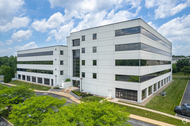
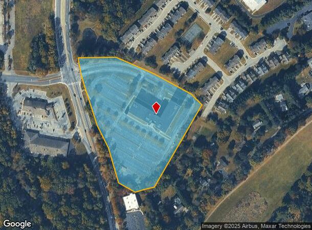
Property Record
4550 Linden Hill Rd, Wilmington, DE 19808

Current Lease Availabilities
NEARBY LISTINGS FOR SALE OR LEASE
Property Detail
4550 Linden Hill Rd
Philadelphia-Camden-Wilmington, PA-NJ-DE-MD
Pk Cr Vly Off Res Ct
08-037.00-046
LEGAL-SHERIFFS DEED SITUATE IN MILL CREEK HUNDRED
Officebuilding
New Castle
X
Delaware
10003C0130L
a
2024
7.88 AC
2024
West New Castle County
013607
Philadelphia
39,200 SF
DEMOGRAPHICS near 4550 Linden Hill Rd
1 Mile
3 Mile
5 Mile
2024 Total Population
9,911
63,387
148,016
2029 Population
10,000
64,185
150,294
Pop Growth 2024-2029
+ 0.90%
+ 1.26%
+ 1.54%
Average Age
42
43
41
2024 Total Households
4,242
25,552
56,746
HH Growth 2024-2029
+ 0.92%
+ 1.30%
+ 1.60%
Median Household Inc
$92,974
$90,763
$79,176
Avg Household Size
2.20
2.40
2.40
2024 Avg HH Vehicles
2.00
2.00
2.00
Median Home Value
$318,659
$304,370
$296,699
Median Year Built
1981
1976
1973
Nearby Places
Map Layers
Map Styles
 Street
 Aerial
- Restaurants
- Banks
- Shops
- Fitness
- Groceries
PUBLIC TRANSPORTATION
AIRPORT
Philadelphia International
DRIVE
WALK
Distance
Philadelphia International
41 min
32.7 mi
Freight Ports
Port of Wilmington, RI
DRIVE
WALK
Distance
Port of Wilmington, RI
1 min
8.9 mi
Nearby Properties
Address
Land Use
TOTAL SIZE
Lot Size
Zoning
Address
Land Use
TOTAL SIZE
Lot Size
Zoning
118,400 SF
59.44 AC
S
Address
Land Use
TOTAL SIZE
Lot Size
Zoning
Address
Land Use
TOTAL SIZE
Lot Size
Zoning
3,509 SF
24.91 AC
S
Address
Land Use
TOTAL SIZE
Lot Size
Zoning
228,832 SF
19.38 AC
ST
Address
Land Use
TOTAL SIZE
Lot Size
Zoning
Address
Land Use
TOTAL SIZE
Lot Size
Zoning
7,146 SF
20 AC
S
Address
Land Use
TOTAL SIZE
Lot Size
Zoning
120,751 SF
42.10 AC
CR
Address
Land Use
TOTAL SIZE
Lot Size
Zoning
144,415 SF
19.53 AC
OR
Address
Land Use
TOTAL SIZE
Lot Size
Zoning
126,048 SF
24.42 AC
OR
Address
Land Use
TOTAL SIZE
Lot Size
Zoning
65,112 SF
30.74 AC
CR
Address
Land Use
TOTAL SIZE
Lot Size
Zoning
125,650 SF
39.91 AC
S
Address
Land Use
TOTAL SIZE
Lot Size
Zoning
194,234 SF
67.12 AC
S
Address
Land Use
TOTAL SIZE
Lot Size
Zoning
101,178 SF
16.60 AC
OR
Address
Land Use
TOTAL SIZE
Lot Size
Zoning
269,354 SF
29.13 AC
NCPUD
Address
Land Use
TOTAL SIZE
Lot Size
Zoning
225,947 SF
18.68 AC
NCAP
Address
Land Use
TOTAL SIZE
Lot Size
Zoning
94,470 SF
22.40 AC
CR
Address
Land Use
TOTAL SIZE
Lot Size
Zoning
332,800 SF
18.70 AC
NCAP
Address
Land Use
TOTAL SIZE
Lot Size
Zoning
22,211 SF
14.86 AC
ON
Address
Land Use
TOTAL SIZE
Lot Size
Zoning
256,666 SF
60.73 AC
OR
Address
Land Use
TOTAL SIZE
Lot Size
Zoning
Address
Land Use
TOTAL SIZE
Lot Size
Zoning
2,707 SF
116.94 AC
NCMM
Address
Land Use
TOTAL SIZE
Lot Size
Zoning
16,588 SF
72.24 AC
S
Address
Land Use
TOTAL SIZE
Lot Size
Zoning
209,111 SF
43.56 AC
S
Address
Land Use
TOTAL SIZE
Lot Size
Zoning
12,648 SF
15.20 AC
NC6.5
Address
Land Use
TOTAL SIZE
Lot Size
Zoning
17,087 SF
45.67 AC
S
Address
Land Use
TOTAL SIZE
Lot Size
Zoning
448 SF
10.12 AC
NCAP
Address
Land Use
TOTAL SIZE
Lot Size
Zoning
82,545 SF
13.44 AC
CR
Address
Land Use
TOTAL SIZE
Lot Size
Zoning
40,633 SF
18.48 AC
S
Address
Land Use
TOTAL SIZE
Lot Size
Zoning
101,733 SF
85.55 AC
S
The World's #1 Commercial Real Estate Marketplace
Connect with us
© 2026 CoStar Group
The information above has been obtained from sources believed reliable. While we do not doubt its accuracy we have not verified it and make no guarantee, warranty or representation about it. It is your responsibility to independently confirm its accuracy and completeness. Any projections, opinions, assumptions, or estimates used are for example only and do not represent the current or future performance of the property. The value of this transaction to you depends on tax and other factors which should be evaluated by your tax, financial, and legal advisors. You and your advisors should conduct a careful, independent investigation of the property to determine to your satisfaction the suitability of the property for your needs.