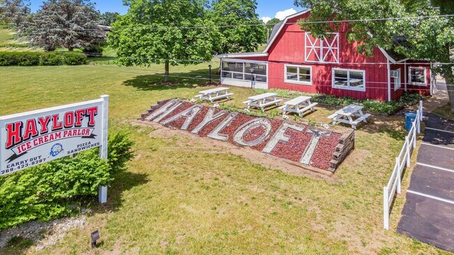
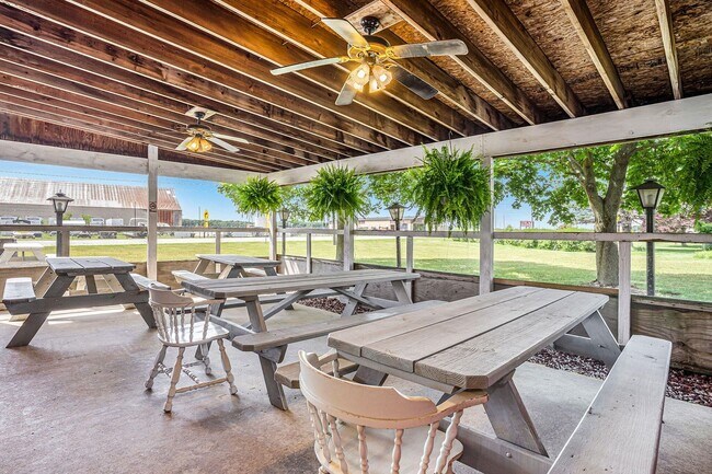
Property Record
45502 M 51, Decatur, MI 49045

NEARBY LISTINGS FOR SALE OR LEASE
-
-
View all Decatur listings for sale on LoopNet.com
Property Detail
45502 M 51
Kalamazoo-Portage, MI
Van Buren
80-08-019-032-20
Michigan
Modularprefabricatedhomes
3 AC
X
Van Buren County
26159C0450C
West Michigan
2,726 SF
DEMOGRAPHICS near 45502 M 51
1 Mile
3 Mile
5 Mile
2024 Total Population
1,005
3,064
4,900
2029 Population
991
3,033
4,875
Pop Growth 2024-2029
(1.39%)
(1.01%)
(0.51%)
Average Age
41
41
42
2024 Total Households
403
1,207
1,915
HH Growth 2024-2029
(1.74%)
(1.33%)
(0.73%)
Median Household Inc
$51,371
$53,957
$54,327
Avg Household Size
2.50
2.50
2.50
2024 Avg HH Vehicles
2.00
2.00
2.00
Median Home Value
$118,800
$144,044
$160,701
Median Year Built
1955
1960
1968
Nearby Places
Map Layers
Map Styles
 Street
 Aerial
- Restaurants
- Banks
- Shops
- Fitness
- Groceries
PUBLIC TRANSPORTATION
AIRPORT
Kalamazoo/Battle Creek International
DRIVE
WALK
Distance
Kalamazoo/Battle Creek International
41 min
30.4 mi
Freight Ports
Port Milwaukee
DRIVE
WALK
Distance
Port Milwaukee
257 min
215.8 mi
SALE & LEASE HISTORY
LISTING DATE
SALE/LEASE

Jun 14, 2022
For Sale
Nearby Properties
Address
Land Use
TOTAL SIZE
Lot Size
Zoning
Address
Land Use
TOTAL SIZE
Lot Size
Zoning
9,284 SF
2.31 AC
Address
Land Use
TOTAL SIZE
Lot Size
Zoning
4,970 SF
269 AC
Address
Land Use
TOTAL SIZE
Lot Size
Zoning
1,680 SF
32.97 AC
C-1
Address
Land Use
TOTAL SIZE
Lot Size
Zoning
4,970 SF
229 AC
Address
Land Use
TOTAL SIZE
Lot Size
Zoning
291.73 AC
AG
Address
Land Use
TOTAL SIZE
Lot Size
Zoning
4,150 SF
160.88 AC
AG
Address
Land Use
TOTAL SIZE
Lot Size
Zoning
2,522 SF
189.06 AC
Address
Land Use
TOTAL SIZE
Lot Size
Zoning
11,796 SF
2.12 AC
Address
Land Use
TOTAL SIZE
Lot Size
Zoning
101,880 SF
3.30 AC
Address
Land Use
TOTAL SIZE
Lot Size
Zoning
62,566 SF
20 AC
Address
Land Use
TOTAL SIZE
Lot Size
Zoning
0.88 AC
Address
Land Use
TOTAL SIZE
Lot Size
Zoning
3,233 SF
20.30 AC
C-1
Address
Land Use
TOTAL SIZE
Lot Size
Zoning
218 AC
AG
Address
Land Use
TOTAL SIZE
Lot Size
Zoning
130 AC
Address
Land Use
TOTAL SIZE
Lot Size
Zoning
185.86 AC
AG
Address
Land Use
TOTAL SIZE
Lot Size
Zoning
176.14 AC
AG
Address
Land Use
TOTAL SIZE
Lot Size
Zoning
3,729 SF
75.02 AC
Address
Land Use
TOTAL SIZE
Lot Size
Zoning
3,593 SF
79.46 AC
AG
Address
Land Use
TOTAL SIZE
Lot Size
Zoning
53,600 SF
Address
Land Use
TOTAL SIZE
Lot Size
Zoning
152.10 AC
Address
Land Use
TOTAL SIZE
Lot Size
Zoning
80,044 SF
2.67 AC
Address
Land Use
TOTAL SIZE
Lot Size
Zoning
148.49 AC
AG
Address
Land Use
TOTAL SIZE
Lot Size
Zoning
2,688 SF
38.84 AC
AG
Address
Land Use
TOTAL SIZE
Lot Size
Zoning
139.58 AC
Address
Land Use
TOTAL SIZE
Lot Size
Zoning
131.52 AC
Address
Land Use
TOTAL SIZE
Lot Size
Zoning
1,764 SF
96.96 AC
AG
Address
Land Use
TOTAL SIZE
Lot Size
Zoning
784 SF
100 AC
Address
Land Use
TOTAL SIZE
Lot Size
Zoning
87.42 AC
AG
Address
Land Use
TOTAL SIZE
Lot Size
Zoning
2,295 SF
74 AC
Address
Land Use
TOTAL SIZE
Lot Size
Zoning
120 AC
The World's #1 Commercial Real Estate Marketplace
Connect with us
© 2025 CoStar Group
The information above has been obtained from sources believed reliable. While we do not doubt its accuracy we have not verified it and make no guarantee, warranty or representation about it. It is your responsibility to independently confirm its accuracy and completeness. Any projections, opinions, assumptions, or estimates used are for example only and do not represent the current or future performance of the property. The value of this transaction to you depends on tax and other factors which should be evaluated by your tax, financial, and legal advisors. You and your advisors should conduct a careful, independent investigation of the property to determine to your satisfaction the suitability of the property for your needs.