Property Record
4551 Woodbine Rd, Milton, FL 32571

NEARBY LISTINGS FOR SALE OR LEASE
-
-
View all Milton listings for sale on LoopNet.com
Property Detail
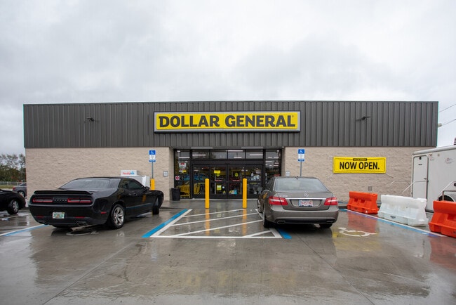
4551 Woodbine Rd
Pensacola-Ferry Pass-Brent, FL
**UPDATED 2024** SECTION 18 TOWNSHIP 1N RANGE 28W TRACT 1A: COM NE COR OF SEC 18 TH S023438W 905.81 FT TH N872946W 50.19 FT TO WLY R/W WOODBINE RD & NLY R/W PEARL RIDGE RD FOR POB TH N873027W 532.03 FT TH N101139E 176.75 FT TH S880633E 399.73 FT TH N
18-1N-29-0000-00206-0000
Santa Rosa
Storebuilding
Florida
2024
2.23 AC
2025
Gonzalez/SW Santa Rosa
010707
Pensacola
12,285 SF
DEMOGRAPHICS near 4551 Woodbine Rd
1 Mile
3 Mile
5 Mile
2024 Total Population
1,944
18,198
44,476
2029 Population
2,205
20,875
50,256
Pop Growth 2024-2029
+ 13.43%
+ 14.71%
+ 13.00%
Average Age
40
39
40
2024 Total Households
696
6,672
15,979
HH Growth 2024-2029
+ 13.65%
+ 14.96%
+ 13.36%
Median Household Inc
$100,421
$72,862
$76,936
Avg Household Size
2.70
2.70
2.70
2024 Avg HH Vehicles
3.00
2.00
2.00
Median Home Value
$245,652
$261,762
$264,254
Median Year Built
1990
1994
1997
Nearby Places
Map Layers
Map Styles
 Street
 Aerial
- Restaurants
- Banks
- Shops
- Fitness
- Groceries
PUBLIC TRANSPORTATION
AIRPORT
Pensacola International
DRIVE
WALK
Distance
Pensacola International
22 min
12.2 mi
Freight Ports
Port of Mobile
DRIVE
WALK
Distance
Port of Mobile
73 min
61.1 mi
Nearby Properties
Address
Land Use
TOTAL SIZE
Lot Size
Zoning
Address
Land Use
TOTAL SIZE
Lot Size
Zoning
47.05 AC
AG-RR
Address
Land Use
TOTAL SIZE
Lot Size
Zoning
52,875 SF
5.24 AC
HCD
Address
Land Use
TOTAL SIZE
Lot Size
Zoning
51,329 SF
5.65 AC
HCD
Address
Land Use
TOTAL SIZE
Lot Size
Zoning
81,123 SF
8.78 AC
HCD
Address
Land Use
TOTAL SIZE
Lot Size
Zoning
60,129 SF
0.11 AC
HCD
Address
Land Use
TOTAL SIZE
Lot Size
Zoning
23.33 AC
AG-RR
Address
Land Use
TOTAL SIZE
Lot Size
Zoning
13.70 AC
HCD
Address
Land Use
TOTAL SIZE
Lot Size
Zoning
76,674 SF
2.80 AC
HCD
Address
Land Use
TOTAL SIZE
Lot Size
Zoning
93,476 SF
7.43 AC
HCD
Address
Land Use
TOTAL SIZE
Lot Size
Zoning
389.54 AC
AG-RR
Address
Land Use
TOTAL SIZE
Lot Size
Zoning
112,196 SF
343.01 AC
HCD
Address
Land Use
TOTAL SIZE
Lot Size
Zoning
50,616 SF
2.56 AC
R3
Address
Land Use
TOTAL SIZE
Lot Size
Zoning
30,564 SF
11.12 AC
HCD
Address
Land Use
TOTAL SIZE
Lot Size
Zoning
23,668 SF
2.30 AC
HCD
Address
Land Use
TOTAL SIZE
Lot Size
Zoning
13,560 SF
5.93 AC
HCD
Address
Land Use
TOTAL SIZE
Lot Size
Zoning
45,485 SF
6.49 AC
HCD
Address
Land Use
TOTAL SIZE
Lot Size
Zoning
62,174 SF
4 AC
HCD
Address
Land Use
TOTAL SIZE
Lot Size
Zoning
63,181 SF
6.61 AC
R2
Address
Land Use
TOTAL SIZE
Lot Size
Zoning
40,250 SF
2.19 AC
HCD
Address
Land Use
TOTAL SIZE
Lot Size
Zoning
25,700 SF
4.34 AC
HCD
Address
Land Use
TOTAL SIZE
Lot Size
Zoning
35,878 SF
10 AC
HCD
Address
Land Use
TOTAL SIZE
Lot Size
Zoning
26,638 SF
3.08 AC
HCD
Address
Land Use
TOTAL SIZE
Lot Size
Zoning
16,596 SF
1.29 AC
HCD
Address
Land Use
TOTAL SIZE
Lot Size
Zoning
27,839 SF
4 AC
AG-RR
Address
Land Use
TOTAL SIZE
Lot Size
Zoning
15,573 SF
1.65 AC
HCD
Address
Land Use
TOTAL SIZE
Lot Size
Zoning
34,880 SF
2.42 AC
HCD
Address
Land Use
TOTAL SIZE
Lot Size
Zoning
16,675 SF
2 AC
HCD
Address
Land Use
TOTAL SIZE
Lot Size
Zoning
14,765 SF
173.09 AC
R1
Address
Land Use
TOTAL SIZE
Lot Size
Zoning
41,800 SF
3.81 AC
HCD
The World's #1 Commercial Real Estate Marketplace
Connect with us
© 2026 CoStar Group
The information above has been obtained from sources believed reliable. While we do not doubt its accuracy we have not verified it and make no guarantee, warranty or representation about it. It is your responsibility to independently confirm its accuracy and completeness. Any projections, opinions, assumptions, or estimates used are for example only and do not represent the current or future performance of the property. The value of this transaction to you depends on tax and other factors which should be evaluated by your tax, financial, and legal advisors. You and your advisors should conduct a careful, independent investigation of the property to determine to your satisfaction the suitability of the property for your needs.