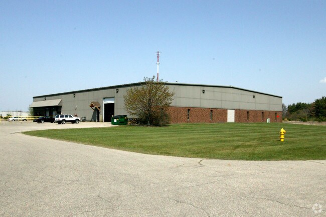
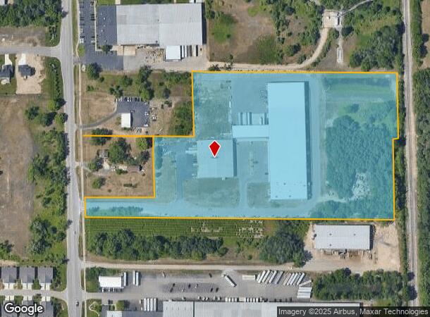
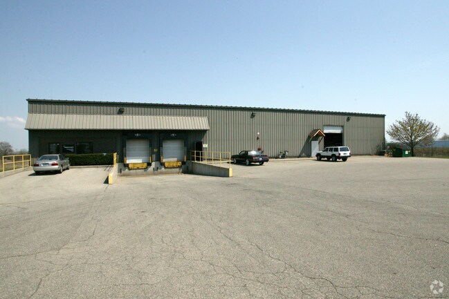
Property Record
4552 136Th Ave, Holland, MI 49424
NEARBY LISTINGS FOR SALE OR LEASE
Property Detail
4552 136Th Ave
70-16-05-100-024
PART OF NW 1/4 COM N 02D 12M 45S W 115143 FT & N 89D 18M 56S E 5002 FT FROM W 1/4 COR, TH N 02D 12M 45S W 71 FT ALG E LI OF
Lightindustrial
Ottawa
X
Michigan
26005C0050G
13.06 AC
2024
Holland North
2025
West Michigan
023102
Grand Rapids-Wyoming, MI
21,070 SF
DEMOGRAPHICS near 4552 136Th Ave
1 Mile
3 Mile
5 Mile
2024 Total Population
2,062
26,530
63,254
2029 Population
2,197
27,790
66,242
Pop Growth 2024-2029
+ 6.55%
+ 4.75%
+ 4.72%
Average Age
33
36
38
2024 Total Households
706
9,669
22,813
HH Growth 2024-2029
+ 6.66%
+ 4.95%
+ 4.97%
Median Household Inc
$81,076
$67,717
$75,143
Avg Household Size
2.80
2.70
2.60
2024 Avg HH Vehicles
3.00
2.00
2.00
Median Home Value
$244,021
$212,948
$245,787
Median Year Built
1996
1991
1987
Nearby Places
Map Layers
Map Styles
 Street
 Aerial
- Restaurants
- Banks
- Shops
- Fitness
- Groceries
PUBLIC TRANSPORTATION
COMMUTER RAIL
Holland Amtrak Station (Pere Marquette - Amtrak)
DRIVE
WALK
Distance
Holland Amtrak Station (Pere Marquette - Amtrak)
12 min
6.5 mi
Freight Ports
Port Milwaukee
DRIVE
WALK
Distance
Port Milwaukee
287 min
242.1 mi
SALE & LEASE HISTORY
LISTING DATE
SALE/LEASE

Sep 24, 2016
For Sale
Sep 15, 2017
For Sale
Jun 25, 2018
For Lease
Nearby Properties
Address
Land Use
TOTAL SIZE
Lot Size
Zoning
Address
Land Use
TOTAL SIZE
Lot Size
Zoning
377,049 SF
24.47 AC
I-2
Address
Land Use
TOTAL SIZE
Lot Size
Zoning
346,440 SF
32.15 AC
PUD
Address
Land Use
TOTAL SIZE
Lot Size
Zoning
362,916 SF
19.23 AC
I-2
Address
Land Use
TOTAL SIZE
Lot Size
Zoning
391,255 SF
40.67 AC
I-2
Address
Land Use
TOTAL SIZE
Lot Size
Zoning
3,150 SF
25.40 AC
AG
Address
Land Use
TOTAL SIZE
Lot Size
Zoning
176,802 SF
17.58 AC
AG
Address
Land Use
TOTAL SIZE
Lot Size
Zoning
320,270 SF
33.25 AC
PUD
Address
Land Use
TOTAL SIZE
Lot Size
Zoning
131,497 SF
37.54 AC
I-2
Address
Land Use
TOTAL SIZE
Lot Size
Zoning
1,040 SF
32.85 AC
I-2
Address
Land Use
TOTAL SIZE
Lot Size
Zoning
83,100 SF
Address
Land Use
TOTAL SIZE
Lot Size
Zoning
137,917 SF
I-2
Address
Land Use
TOTAL SIZE
Lot Size
Zoning
19.20 AC
AG
Address
Land Use
TOTAL SIZE
Lot Size
Zoning
90,508 SF
I-2
Address
Land Use
TOTAL SIZE
Lot Size
Zoning
210,792 SF
22.91 AC
C-2
Address
Land Use
TOTAL SIZE
Lot Size
Zoning
222,767 SF
26.59 AC
I-2
Address
Land Use
TOTAL SIZE
Lot Size
Zoning
Address
Land Use
TOTAL SIZE
Lot Size
Zoning
144,764 SF
16.32 AC
R-3
Address
Land Use
TOTAL SIZE
Lot Size
Zoning
149,348 SF
9.22 AC
I-2
Address
Land Use
TOTAL SIZE
Lot Size
Zoning
65.75 AC
PUD
Address
Land Use
TOTAL SIZE
Lot Size
Zoning
1,801 SF
23.26 AC
PUD
Address
Land Use
TOTAL SIZE
Lot Size
Zoning
195,000 SF
13.70 AC
I-1
Address
Land Use
TOTAL SIZE
Lot Size
Zoning
180,160 SF
Address
Land Use
TOTAL SIZE
Lot Size
Zoning
127,432 SF
3.77 AC
C-2
Address
Land Use
TOTAL SIZE
Lot Size
Zoning
2,173 SF
77.26 AC
R-4
Address
Land Use
TOTAL SIZE
Lot Size
Zoning
177,200 SF
38.01 AC
I-2
Address
Land Use
TOTAL SIZE
Lot Size
Zoning
131,573 SF
13.04 AC
C-2
Address
Land Use
TOTAL SIZE
Lot Size
Zoning
1,240 SF
90.07 AC
PUD
Address
Land Use
TOTAL SIZE
Lot Size
Zoning
198,150 SF
10.26 AC
I-2
Address
Land Use
TOTAL SIZE
Lot Size
Zoning
366,455 SF
21.63 AC
I-2
Address
Land Use
TOTAL SIZE
Lot Size
Zoning
110,461 SF
10.96 AC
C-2
The World's #1 Commercial Real Estate Marketplace
Connect with us
© 2025 CoStar Group
The information above has been obtained from sources believed reliable. While we do not doubt its accuracy we have not verified it and make no guarantee, warranty or representation about it. It is your responsibility to independently confirm its accuracy and completeness. Any projections, opinions, assumptions, or estimates used are for example only and do not represent the current or future performance of the property. The value of this transaction to you depends on tax and other factors which should be evaluated by your tax, financial, and legal advisors. You and your advisors should conduct a careful, independent investigation of the property to determine to your satisfaction the suitability of the property for your needs.