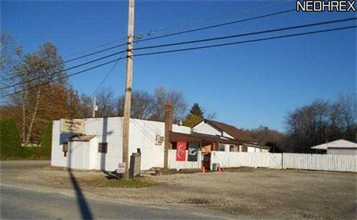
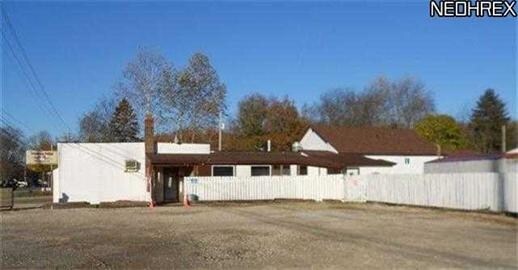
Property Record
4552 Maple Dr, Newton Falls, OH 44444
Property Detail
4552 Maple Dr
Youngstown-Warren, OH
177 45.71F LIBERTY MAPLE DR
51-411835
Trumbull
Restaurantbuilding
Ohio
B and X Area of moderate flood hazard, usually the area between the limits of the 100-year and 500-year floods.
177
2024
0.14 AC
2024
Trumbull County
933500
Youngstown/Warren/Boardman
884 SF
NEARBY LISTINGS FOR SALE OR LEASE
-
-
View all Newton Falls listings for sale on LoopNet.com
DEMOGRAPHICS near 4552 Maple Dr
1 mile
3 mile
5 mile
2025 Total Population
3,797
8,772
13,973
2030 Population
3,786
8,693
13,877
Pop Growth 2025-2030
(0.29%)
(0.90%)
(0.69%)
Average Age
43
44
44
2025 Total Households
1,636
3,877
6,055
HH Growth 2025-2030
(0.31%)
(0.90%)
(0.73%)
Median Household Inc
$57,089
$55,852
$58,519
Avg Household Size
2.20
2.20
2.30
2025 Avg HH Vehicles
2.00
2.00
2.00
Median Home Value
$145,517
$157,097
$166,074
Median Year Built
1959
1964
1968
Nearby Places
Map Layers
Map Styles
 Street
 Aerial
Transit
 Traffic
 Biking
Places
Listings with unknown addresses are not visible on the map
- Restaurants
- Banks
- Shops
- Fitness
- Groceries
PUBLIC TRANSPORTATION
AIRPORT
Akron-Canton Regional
Drive
Walk
Distance
Akron-Canton Regional
61 min
44.3 mi
SALE & LEASE HISTORY
LISTING DATE
SALE/LEASE

Sep 24, 2016
For Sale
Nearby Properties
Address
Land Use
TOTAL SIZE
Lot Size
Zoning
Address
Land Use
TOTAL SIZE
Lot Size
Zoning
5.32 AC
Address
Land Use
TOTAL SIZE
Lot Size
Zoning
50,236 SF
60 AC
Address
Land Use
TOTAL SIZE
Lot Size
Zoning
Address
Land Use
TOTAL SIZE
Lot Size
Zoning
2,664 SF
10.14 AC
Address
Land Use
TOTAL SIZE
Lot Size
Zoning
13.61 AC
Address
Land Use
TOTAL SIZE
Lot Size
Zoning
11.38 AC
Address
Land Use
TOTAL SIZE
Lot Size
Zoning
149.87 AC
Address
Land Use
TOTAL SIZE
Lot Size
Zoning
5,928 SF
18.24 AC
Address
Land Use
TOTAL SIZE
Lot Size
Zoning
36,135 SF
3.60 AC
Address
Land Use
TOTAL SIZE
Lot Size
Zoning
672.43 AC
Address
Land Use
TOTAL SIZE
Lot Size
Zoning
1,403 SF
8.22 AC
Address
Land Use
TOTAL SIZE
Lot Size
Zoning
17,563 SF
3.10 AC
Address
Land Use
TOTAL SIZE
Lot Size
Zoning
2,304 SF
48.42 AC
Address
Land Use
TOTAL SIZE
Lot Size
Zoning
70,469 SF
4.73 AC
Address
Land Use
TOTAL SIZE
Lot Size
Zoning
35,933 SF
1.31 AC
Address
Land Use
TOTAL SIZE
Lot Size
Zoning
3,456 SF
4.20 AC
Address
Land Use
TOTAL SIZE
Lot Size
Zoning
11,201 SF
0.99 AC
Address
Land Use
TOTAL SIZE
Lot Size
Zoning
19,072 SF
2.39 AC
Address
Land Use
TOTAL SIZE
Lot Size
Zoning
35,744 SF
2.09 AC
Address
Land Use
TOTAL SIZE
Lot Size
Zoning
6,426 SF
8.92 AC
Address
Land Use
TOTAL SIZE
Lot Size
Zoning
42,216 SF
2.36 AC
Address
Land Use
TOTAL SIZE
Lot Size
Zoning
3,456 SF
3.71 AC
Address
Land Use
TOTAL SIZE
Lot Size
Zoning
5,840 SF
0.70 AC
Address
Land Use
TOTAL SIZE
Lot Size
Zoning
848 SF
25.93 AC
Address
Land Use
TOTAL SIZE
Lot Size
Zoning
15,170 SF
2.85 AC
Address
Land Use
TOTAL SIZE
Lot Size
Zoning
13,634 SF
2.55 AC
Address
Land Use
TOTAL SIZE
Lot Size
Zoning
4,991 SF
2.84 AC
Address
Land Use
TOTAL SIZE
Lot Size
Zoning
0.36 AC
Address
Land Use
TOTAL SIZE
Lot Size
Zoning
21,500 SF
0.46 AC
Address
Land Use
TOTAL SIZE
Lot Size
Zoning
9,170 SF
1.68 AC
The World's #1 Commercial Real Estate Marketplace
Connect with us
© 2026 CoStar Group
The information above has been obtained from sources believed reliable. While we do not doubt its accuracy we have not verified it and make no guarantee, warranty or representation about it. It is your responsibility to independently confirm its accuracy and completeness. Any projections, opinions, assumptions, or estimates used are for example only and do not represent the current or future performance of the property. The value of this transaction to you depends on tax and other factors which should be evaluated by your tax, financial, and legal advisors. You and your advisors should conduct a careful, independent investigation of the property to determine to your satisfaction the suitability of the property for your needs.