Property Record
4553 County 40 Nw, Hackensack, MN 56452
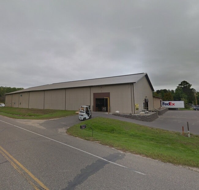
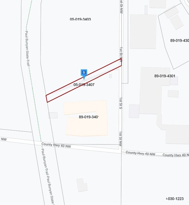
Property Detail
4553 County 40 Nw
Other Market Areas
OLD APN 05-019-3403
Brainerd, MN
CASS
89-030-1223
Minnesota
Industrialgeneral
b
2025
5.35 AC
2024
Minnesota North Area
960301
NEARBY LISTINGS FOR SALE OR LEASE
-
-
View all Hackensack listings for sale on LoopNet.com
DEMOGRAPHICS near 4553 County 40 Nw
1 mile
3 mile
5 mile
2025 Total Population
277
832
1,815
2030 Population
289
870
1,911
Pop Growth 2025-2030
+ 4.33%
+ 4.57%
+ 5.29%
Average Age
50
51
51
2025 Total Households
126
386
853
HH Growth 2025-2030
+ 3.97%
+ 4.15%
+ 5.16%
Median Household Inc
$50,833
$52,875
$56,315
Avg Household Size
2.10
2.10
2.00
2025 Avg HH Vehicles
2.00
2.00
2.00
Median Home Value
$257,692
$269,374
$291,436
Median Year Built
1988
1990
1991
Nearby Places
Map Layers
Map Styles
 Street
 Aerial
Transit
 Traffic
 Biking
Places
Listings with unknown addresses are not visible on the map
- Restaurants
- Banks
- Shops
- Fitness
- Groceries
Nearby Properties
Address
Land Use
TOTAL SIZE
Lot Size
Zoning
Address
Land Use
TOTAL SIZE
Lot Size
Zoning
17,790 SF
1.28 AC
Address
Land Use
TOTAL SIZE
Lot Size
Zoning
3,100 SF
8.20 AC
Address
Land Use
TOTAL SIZE
Lot Size
Zoning
2.94 AC
Address
Land Use
TOTAL SIZE
Lot Size
Zoning
1.33 AC
Address
Land Use
TOTAL SIZE
Lot Size
Zoning
22.82 AC
Address
Land Use
TOTAL SIZE
Lot Size
Zoning
0.13 AC
Address
Land Use
TOTAL SIZE
Lot Size
Zoning
0.05 AC
Address
Land Use
TOTAL SIZE
Lot Size
Zoning
Address
Land Use
TOTAL SIZE
Lot Size
Zoning
0.05 AC
Address
Land Use
TOTAL SIZE
Lot Size
Zoning
0.05 AC
Address
Land Use
TOTAL SIZE
Lot Size
Zoning
6,250 SF
8 AC
Address
Land Use
TOTAL SIZE
Lot Size
Zoning
8,984 SF
2.82 AC
Address
Land Use
TOTAL SIZE
Lot Size
Zoning
2,560 SF
35.34 AC
Address
Land Use
TOTAL SIZE
Lot Size
Zoning
268.48 AC
Address
Land Use
TOTAL SIZE
Lot Size
Zoning
1,176 SF
80.09 AC
Address
Land Use
TOTAL SIZE
Lot Size
Zoning
3.90 AC
Address
Land Use
TOTAL SIZE
Lot Size
Zoning
1,176 SF
39.74 AC
Address
Land Use
TOTAL SIZE
Lot Size
Zoning
Address
Land Use
TOTAL SIZE
Lot Size
Zoning
6,400 SF
3.77 AC
Address
Land Use
TOTAL SIZE
Lot Size
Zoning
Address
Land Use
TOTAL SIZE
Lot Size
Zoning
5,292 SF
6.66 AC
Address
Land Use
TOTAL SIZE
Lot Size
Zoning
13.56 AC
Address
Land Use
TOTAL SIZE
Lot Size
Zoning
Address
Land Use
TOTAL SIZE
Lot Size
Zoning
1,584 SF
39.95 AC
Address
Land Use
TOTAL SIZE
Lot Size
Zoning
1,646 SF
5.28 AC
Address
Land Use
TOTAL SIZE
Lot Size
Zoning
Address
Land Use
TOTAL SIZE
Lot Size
Zoning
0.06 AC
Address
Land Use
TOTAL SIZE
Lot Size
Zoning
0.31 AC
Address
Land Use
TOTAL SIZE
Lot Size
Zoning
10.07 AC
Address
Land Use
TOTAL SIZE
Lot Size
Zoning
The World's #1 Commercial Real Estate Marketplace
Connect with us
© 2026 CoStar Group
The information above has been obtained from sources believed reliable. While we do not doubt its accuracy we have not verified it and make no guarantee, warranty or representation about it. It is your responsibility to independently confirm its accuracy and completeness. Any projections, opinions, assumptions, or estimates used are for example only and do not represent the current or future performance of the property. The value of this transaction to you depends on tax and other factors which should be evaluated by your tax, financial, and legal advisors. You and your advisors should conduct a careful, independent investigation of the property to determine to your satisfaction the suitability of the property for your needs.