Property Record
45535 Mound Rd, Shelby Township, MI 48317


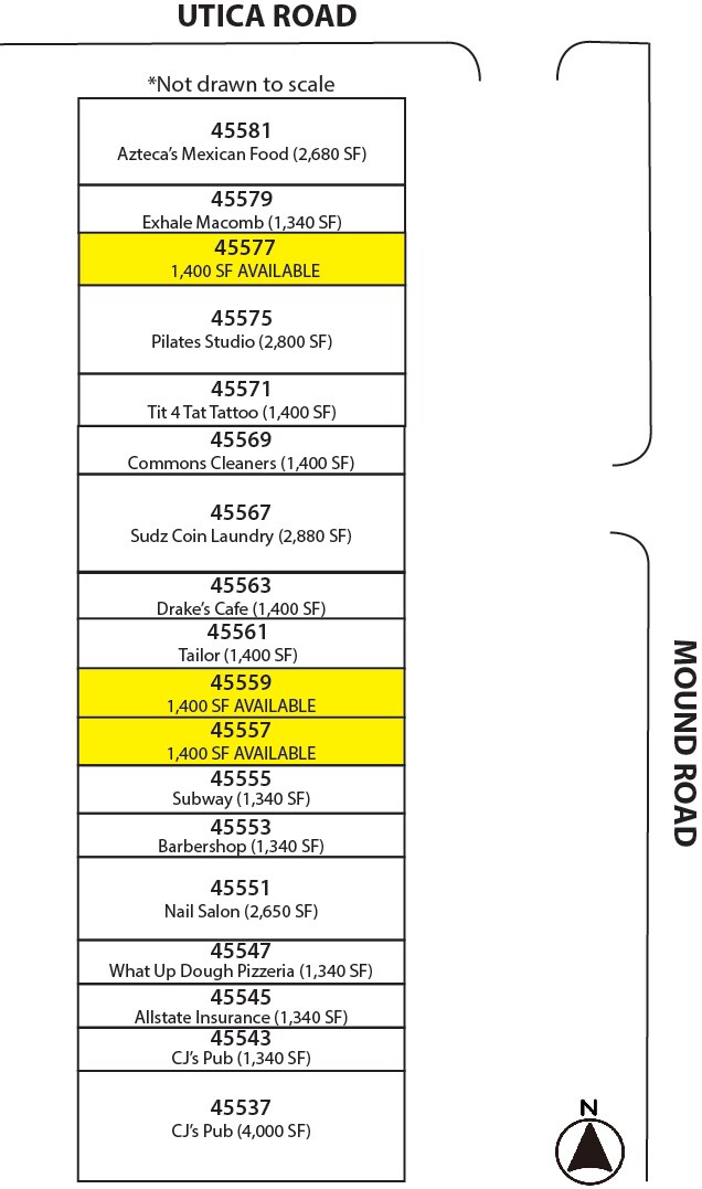
Current Lease Availabilities
NEARBY LISTINGS FOR SALE OR LEASE
Property Detail
45535 Mound Rd
23-07-32-476-012
T3N,R12E,SEC 32,COM AT THE SE UTICA COMMUNITY SCHOOLS
Commercialnec
Macomb
X
Michigan
26099C0218G
3.53 AC
2025
Macomb West
2025
Detroit
225701
Detroit-Warren-Dearborn, MI
33,246 SF
DEMOGRAPHICS near 45535 Mound Rd
1 Mile
3 Mile
5 Mile
2024 Total Population
9,298
73,678
229,255
2029 Population
9,177
72,975
226,327
Pop Growth 2024-2029
(1.30%)
(0.95%)
(1.28%)
Average Age
40
41
42
2024 Total Households
4,463
29,987
89,317
HH Growth 2024-2029
(1.37%)
(1.02%)
(1.32%)
Median Household Inc
$62,289
$73,038
$82,391
Avg Household Size
2.10
2.40
2.50
2024 Avg HH Vehicles
2.00
2.00
2.00
Median Home Value
$230,578
$257,161
$267,829
Median Year Built
1985
1981
1981
Nearby Places
Map Layers
Map Styles
 Street
 Aerial
- Restaurants
- Banks
- Shops
- Fitness
- Groceries
PUBLIC TRANSPORTATION
AIRPORT
Detroit City
DRIVE
WALK
Distance
Detroit City
38 min
16.9 mi
Freight Ports
Port of Baltimore
DRIVE
WALK
Distance
Port of Baltimore
1 min
409.2 mi
Nearby Properties
Address
Land Use
TOTAL SIZE
Lot Size
Zoning
Address
Land Use
TOTAL SIZE
Lot Size
Zoning
998,316 SF
85.99 AC
CK MAP
Address
Land Use
TOTAL SIZE
Lot Size
Zoning
146.36 AC
MHP
Address
Land Use
TOTAL SIZE
Lot Size
Zoning
92.30 AC
MHP
Address
Land Use
TOTAL SIZE
Lot Size
Zoning
12.38 AC
R-10
Address
Land Use
TOTAL SIZE
Lot Size
Zoning
2,058,062 SF
141.65 AC
M-2
Address
Land Use
TOTAL SIZE
Lot Size
Zoning
332,286 SF
CK MAP
Address
Land Use
TOTAL SIZE
Lot Size
Zoning
46.56 AC
CK MAP
Address
Land Use
TOTAL SIZE
Lot Size
Zoning
283,249 SF
M-2
Address
Land Use
TOTAL SIZE
Lot Size
Zoning
1,150 SF
25.68 AC
CK MAP
Address
Land Use
TOTAL SIZE
Lot Size
Zoning
242,857 SF
9.61 AC
RM-3
Address
Land Use
TOTAL SIZE
Lot Size
Zoning
34.43 AC
CK MAP
Address
Land Use
TOTAL SIZE
Lot Size
Zoning
438,578 SF
36.60 AC
MXD
Address
Land Use
TOTAL SIZE
Lot Size
Zoning
25.18 AC
RM-2
Address
Land Use
TOTAL SIZE
Lot Size
Zoning
41.09 AC
R-7
Address
Land Use
TOTAL SIZE
Lot Size
Zoning
27.89 AC
CK MAP
Address
Land Use
TOTAL SIZE
Lot Size
Zoning
28.58 AC
AI
Address
Land Use
TOTAL SIZE
Lot Size
Zoning
203,282 SF
17.13 AC
C-2
Address
Land Use
TOTAL SIZE
Lot Size
Zoning
190,996 SF
33.80 AC
LM
Address
Land Use
TOTAL SIZE
Lot Size
Zoning
255,070 SF
20.33 AC
RM-2
Address
Land Use
TOTAL SIZE
Lot Size
Zoning
29.93 AC
RM-2
Address
Land Use
TOTAL SIZE
Lot Size
Zoning
19.47 AC
R-8
Address
Land Use
TOTAL SIZE
Lot Size
Zoning
43.80 AC
Address
Land Use
TOTAL SIZE
Lot Size
Zoning
29.39 AC
CK MAP
Address
Land Use
TOTAL SIZE
Lot Size
Zoning
159,750 SF
16.76 AC
M-1
Address
Land Use
TOTAL SIZE
Lot Size
Zoning
1,350 SF
21.90 AC
CK MAP
Address
Land Use
TOTAL SIZE
Lot Size
Zoning
106,130 SF
5.37 AC
O-2
Address
Land Use
TOTAL SIZE
Lot Size
Zoning
167,747 SF
CK MAP
Address
Land Use
TOTAL SIZE
Lot Size
Zoning
554,374 SF
22.15 AC
M-2
Address
Land Use
TOTAL SIZE
Lot Size
Zoning
210,080 SF
14.35 AC
RM-2
Address
Land Use
TOTAL SIZE
Lot Size
Zoning
19.30 AC
CK MAP
The World's #1 Commercial Real Estate Marketplace
Connect with us
© 2026 CoStar Group
The information above has been obtained from sources believed reliable. While we do not doubt its accuracy we have not verified it and make no guarantee, warranty or representation about it. It is your responsibility to independently confirm its accuracy and completeness. Any projections, opinions, assumptions, or estimates used are for example only and do not represent the current or future performance of the property. The value of this transaction to you depends on tax and other factors which should be evaluated by your tax, financial, and legal advisors. You and your advisors should conduct a careful, independent investigation of the property to determine to your satisfaction the suitability of the property for your needs.