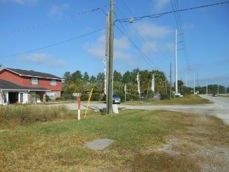
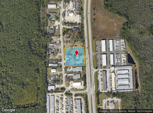
Property Record
4555 N Us Highway 1, Bunnell, FL 32110
NEARBY LISTINGS FOR SALE OR LEASE
Property Detail
4555 N Us Highway 1
22-11-30-0000-03041-0000
0001.47 ACRES PART OF SE1/4 804 NORTH OF SOUTH LINE OF SECTION PARCEL 246 ON US #1 BY 260 DEEP OR BOOK 62 PAGE 103 OR 150 PG 304 OR 245 PG 229, OR 321 PG 674 OR 447 PG 559 (EXC OR 447 PG 561) OR 1085 PG 1876 OR 1603 PG 546- OR 1947/1115 OR 2023/1050
Commercialnec
Flagler
X
Florida
12035C0120E
1.47 AC
2024
Daytona Area
2025
Other Market Areas
060206
Deltona-Daytona Beach-Ormond Beach, FL
2,726 SF
DEMOGRAPHICS near 4555 N Us Highway 1
1 Mile
3 Mile
5 Mile
2024 Total Population
1,445
11,199
27,035
2029 Population
1,791
13,781
32,852
Pop Growth 2024-2029
+ 23.94%
+ 23.06%
+ 21.52%
Average Age
41
42
48
2024 Total Households
543
4,229
11,465
HH Growth 2024-2029
+ 23.20%
+ 22.30%
+ 20.72%
Median Household Inc
$69,612
$68,314
$62,970
Avg Household Size
2.60
2.60
2.30
2024 Avg HH Vehicles
2.00
2.00
2.00
Median Home Value
$295,312
$276,867
$300,764
Median Year Built
2008
2006
2004
Nearby Places
Map Layers
Map Styles
 Street
 Aerial
- Restaurants
- Banks
- Shops
- Fitness
- Groceries
PUBLIC TRANSPORTATION
AIRPORT
Daytona Beach International
DRIVE
WALK
Distance
Daytona Beach International
38 min
31.1 mi
Nearby Properties
Address
Land Use
TOTAL SIZE
Lot Size
Zoning
Address
Land Use
TOTAL SIZE
Lot Size
Zoning
76,792 SF
10.05 AC
COM-2
Address
Land Use
TOTAL SIZE
Lot Size
Zoning
298,470 SF
34.44 AC
MFR-2
Address
Land Use
TOTAL SIZE
Lot Size
Zoning
292,473 SF
45.87 AC
PSP
Address
Land Use
TOTAL SIZE
Lot Size
Zoning
209,585 SF
40 AC
MPD
Address
Land Use
TOTAL SIZE
Lot Size
Zoning
236,316 SF
61.38 AC
PSP
Address
Land Use
TOTAL SIZE
Lot Size
Zoning
137,280 SF
64.40 AC
COM-3
Address
Land Use
TOTAL SIZE
Lot Size
Zoning
93,891 SF
5 AC
MFR-2
Address
Land Use
TOTAL SIZE
Lot Size
Zoning
506,883 SF
24.02 AC
COM-2
Address
Land Use
TOTAL SIZE
Lot Size
Zoning
85,307 SF
4.31 AC
IND-1
Address
Land Use
TOTAL SIZE
Lot Size
Zoning
75,297 SF
15.55 AC
PSP
Address
Land Use
TOTAL SIZE
Lot Size
Zoning
94,320 SF
22.19 AC
PSP
Address
Land Use
TOTAL SIZE
Lot Size
Zoning
57,077 SF
5.19 AC
COM-2
Address
Land Use
TOTAL SIZE
Lot Size
Zoning
61,313 SF
7.78 AC
COM-2
Address
Land Use
TOTAL SIZE
Lot Size
Zoning
77,816 SF
5.95 AC
COM-3
Address
Land Use
TOTAL SIZE
Lot Size
Zoning
144,642 SF
10 AC
IND-1
Address
Land Use
TOTAL SIZE
Lot Size
Zoning
33,700 SF
2.89 AC
Address
Land Use
TOTAL SIZE
Lot Size
Zoning
98.85 AC
MFR-2
Address
Land Use
TOTAL SIZE
Lot Size
Zoning
101,876 SF
9.22 AC
COM-2
Address
Land Use
TOTAL SIZE
Lot Size
Zoning
88,704 SF
7.96 AC
Address
Land Use
TOTAL SIZE
Lot Size
Zoning
77,370 SF
9.31 AC
COM-2
Address
Land Use
TOTAL SIZE
Lot Size
Zoning
28,335 SF
19.31 AC
PSP
Address
Land Use
TOTAL SIZE
Lot Size
Zoning
27,218 SF
8.43 AC
COM-3
Address
Land Use
TOTAL SIZE
Lot Size
Zoning
45,409 SF
3.90 AC
OFC-2
Address
Land Use
TOTAL SIZE
Lot Size
Zoning
5,264 SF
9.61 AC
PSP
Address
Land Use
TOTAL SIZE
Lot Size
Zoning
73,869 SF
7.93 AC
COM-2
Address
Land Use
TOTAL SIZE
Lot Size
Zoning
32,679 SF
101.42 AC
L-1
Address
Land Use
TOTAL SIZE
Lot Size
Zoning
112,200 SF
49.38 AC
L-1
Address
Land Use
TOTAL SIZE
Lot Size
Zoning
163,592 SF
10 AC
IND-1
The World's #1 Commercial Real Estate Marketplace
Connect with us
© 2025 CoStar Group
The information above has been obtained from sources believed reliable. While we do not doubt its accuracy we have not verified it and make no guarantee, warranty or representation about it. It is your responsibility to independently confirm its accuracy and completeness. Any projections, opinions, assumptions, or estimates used are for example only and do not represent the current or future performance of the property. The value of this transaction to you depends on tax and other factors which should be evaluated by your tax, financial, and legal advisors. You and your advisors should conduct a careful, independent investigation of the property to determine to your satisfaction the suitability of the property for your needs.