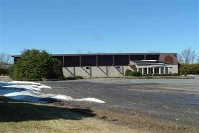
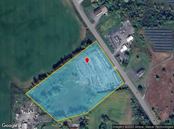
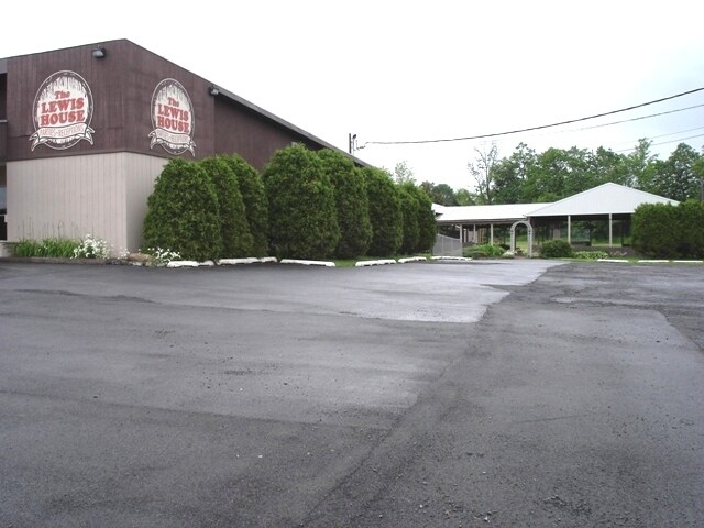
Property Record
4555 Nys Rt 233, Clinton, NY 13323
NEARBY LISTINGS FOR SALE OR LEASE
-
-
View all Clinton listings for lease on LoopNet.com
Property Detail
4555 Nys Rt 233
306800 327.000-6-45.2
Oneida
Commercialnec
New York
X
45.002
36065C0709F
8.50 AC
2024
Outlying Oneida County
2024
Utica/Rome
025002
Utica-Rome, NY
8,990 SF
DEMOGRAPHICS near 4555 Nys Rt 233
1 Mile
3 Mile
5 Mile
2024 Total Population
927
11,537
26,215
2029 Population
913
11,286
25,767
Pop Growth 2024-2029
(1.51%)
(2.18%)
(1.71%)
Average Age
44
43
44
2024 Total Households
405
4,526
10,802
HH Growth 2024-2029
(1.73%)
(2.54%)
(1.86%)
Median Household Inc
$77,174
$71,170
$76,853
Avg Household Size
2.30
2.10
2.20
2024 Avg HH Vehicles
2.00
2.00
2.00
Median Home Value
$214,167
$184,503
$193,218
Median Year Built
1965
1965
1965
Nearby Places
- Restaurants
- Banks
- Shops
- Fitness
- Groceries
PUBLIC TRANSPORTATION
COMMUTER RAIL
Rome (Toronto - New York - VIA Rail)
DRIVE
WALK
Distance
Rome (Toronto - New York - VIA Rail)
13 min
8.9 mi
Rome Amtrak Station (Empire Service - Amtrak, Maple Leaf - Amtrak)
DRIVE
WALK
Distance
Rome Amtrak Station (Empire Service - Amtrak, Maple Leaf - Amtrak)
13 min
8.9 mi
Freight Ports
Albany, NY Port
DRIVE
WALK
Distance
Albany, NY Port
128 min
106.9 mi
SALE & LEASE HISTORY
LISTING DATE
SALE/LEASE

Sep 25, 2016
For Lease
Sep 24, 2016
For Sale
Nearby Properties
Address
Land Use
TOTAL SIZE
Lot Size
Zoning
Address
Land Use
TOTAL SIZE
Lot Size
Zoning
122.70 AC
01 - NOT Z
Address
Land Use
TOTAL SIZE
Lot Size
Zoning
49,900 SF
74.61 AC
Address
Land Use
TOTAL SIZE
Lot Size
Zoning
3,276 SF
6.38 AC
05 - COMME
Address
Land Use
TOTAL SIZE
Lot Size
Zoning
208,282 SF
24.30 AC
Address
Land Use
TOTAL SIZE
Lot Size
Zoning
1,764 SF
75.36 AC
05 - COMME
Address
Land Use
TOTAL SIZE
Lot Size
Zoning
124,169 SF
9.96 AC
05 - COMME
Address
Land Use
TOTAL SIZE
Lot Size
Zoning
131,760 SF
120.07 AC
05 - COMME
Address
Land Use
TOTAL SIZE
Lot Size
Zoning
4,136 SF
92.70 AC
01 - NOT Z
Address
Land Use
TOTAL SIZE
Lot Size
Zoning
3,276 SF
5.33 AC
05 - COMME
Address
Land Use
TOTAL SIZE
Lot Size
Zoning
76,586 SF
35.60 AC
Address
Land Use
TOTAL SIZE
Lot Size
Zoning
75,000 SF
8.75 AC
Address
Land Use
TOTAL SIZE
Lot Size
Zoning
76,000 SF
14 AC
Address
Land Use
TOTAL SIZE
Lot Size
Zoning
99.80 AC
Address
Land Use
TOTAL SIZE
Lot Size
Zoning
55,202 SF
14 AC
01
Address
Land Use
TOTAL SIZE
Lot Size
Zoning
924 SF
20.80 AC
Address
Land Use
TOTAL SIZE
Lot Size
Zoning
Address
Land Use
TOTAL SIZE
Lot Size
Zoning
52,010 SF
3.10 AC
01 - NOT Z
Address
Land Use
TOTAL SIZE
Lot Size
Zoning
65.18 AC
01 - NOT Z
Address
Land Use
TOTAL SIZE
Lot Size
Zoning
76,032 SF
4.50 AC
Address
Land Use
TOTAL SIZE
Lot Size
Zoning
37.26 AC
01
Address
Land Use
TOTAL SIZE
Lot Size
Zoning
20,660 SF
7.54 AC
Address
Land Use
TOTAL SIZE
Lot Size
Zoning
Address
Land Use
TOTAL SIZE
Lot Size
Zoning
Address
Land Use
TOTAL SIZE
Lot Size
Zoning
924 SF
15.80 AC
05 - COMME
Address
Land Use
TOTAL SIZE
Lot Size
Zoning
35,000 SF
3 AC
Address
Land Use
TOTAL SIZE
Lot Size
Zoning
19,928 SF
4.10 AC
01
Address
Land Use
TOTAL SIZE
Lot Size
Zoning
58,400 SF
23 AC
01 - NOT Z
Address
Land Use
TOTAL SIZE
Lot Size
Zoning
Address
Land Use
TOTAL SIZE
Lot Size
Zoning
116.82 AC
AR5A
Address
Land Use
TOTAL SIZE
Lot Size
Zoning
22,136 SF
3 AC
05 - COMME
The World's #1 Commercial Real Estate Marketplace
Connect with us
© 2025 CoStar Group
The information above has been obtained from sources believed reliable. While we do not doubt its accuracy we have not verified it and make no guarantee, warranty or representation about it. It is your responsibility to independently confirm its accuracy and completeness. Any projections, opinions, assumptions, or estimates used are for example only and do not represent the current or future performance of the property. The value of this transaction to you depends on tax and other factors which should be evaluated by your tax, financial, and legal advisors. You and your advisors should conduct a careful, independent investigation of the property to determine to your satisfaction the suitability of the property for your needs.