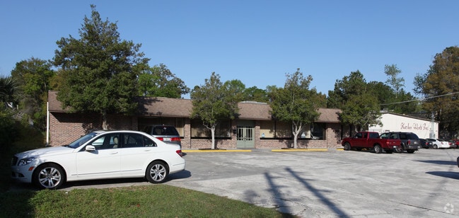
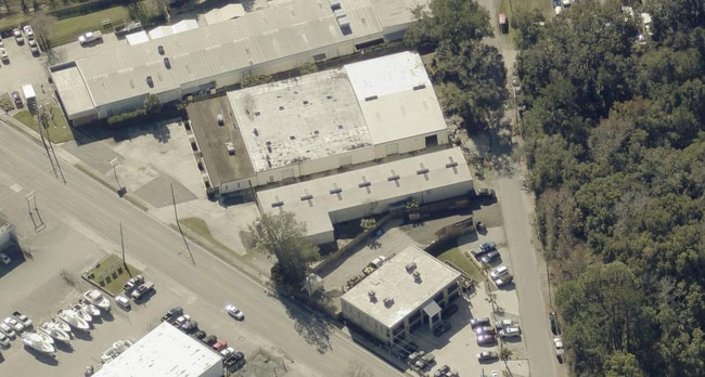
Property Record
4556 Saint Augustine Rd, Jacksonville, FL 32207


This Property Is For Sale
Current Lease Availabilities
Property Detail
4556 Saint Augustine Rd
147455-0100
06-3S-27E 1.28 E1/2 OF NW1/4 PT RECD O/R 19673-1371 BEING PARCELS A,B
Warehouse
Duval
IBP
Florida
B and X Area of moderate flood hazard, usually the area between the limits of the 100-year and 500-year floods.
1.32 AC
2025
Mandarin
2026
Jacksonville (Florida)
016300
Jacksonville, FL
27,486 SF
NEARBY LISTINGS FOR SALE OR LEASE
DEMOGRAPHICS near 4556 Saint Augustine Rd
1 mile
3 mile
5 mile
2025 Total Population
8,243
59,654
173,686
2030 Population
8,745
63,627
184,919
Pop Growth 2025-2030
+ 6.09%
+ 6.66%
+ 6.47%
Average Age
40
40
40
2025 Total Households
3,452
24,964
75,999
HH Growth 2025-2030
+ 6.29%
+ 7.05%
+ 6.90%
Median Household Inc
$60,464
$62,133
$67,885
Avg Household Size
2.30
2.30
2.20
2025 Avg HH Vehicles
2.00
1.00
1.00
Median Home Value
$315,278
$312,441
$340,824
Median Year Built
1959
1966
1972
Nearby Places
Map Layers
Map Styles
 Street
 Aerial
Transit
 Traffic
 Biking
Places
Listings with unknown addresses are not visible on the map
- Restaurants
- Banks
- Shops
- Fitness
- Groceries
PUBLIC TRANSPORTATION
AIRPORT
Jacksonville International
Drive
Walk
Distance
Jacksonville International
33 min
19.5 mi
Freight Ports
Jacksonville Port
Drive
Walk
Distance
Jacksonville Port
17 min
8.8 mi
Nearby Properties
Address
Land Use
TOTAL SIZE
Lot Size
Zoning
Address
Land Use
TOTAL SIZE
Lot Size
Zoning
875,866 SF
22.33 AC
PBF-3
Address
Land Use
TOTAL SIZE
Lot Size
Zoning
257,667 SF
3.91 AC
CCBD
Address
Land Use
TOTAL SIZE
Lot Size
Zoning
224,600 SF
3.41 AC
PUD
Address
Land Use
TOTAL SIZE
Lot Size
Zoning
253,858 SF
4.93 AC
PUD
Address
Land Use
TOTAL SIZE
Lot Size
Zoning
316,705 SF
15.44 AC
PUD
Address
Land Use
TOTAL SIZE
Lot Size
Zoning
250,989 SF
19.48 AC
PUD
Address
Land Use
TOTAL SIZE
Lot Size
Zoning
211,073 SF
8.99 AC
PUD
Address
Land Use
TOTAL SIZE
Lot Size
Zoning
203,763 SF
9.97 AC
PUD
Address
Land Use
TOTAL SIZE
Lot Size
Zoning
181,522 SF
6.56 AC
PUD
Address
Land Use
TOTAL SIZE
Lot Size
Zoning
313,009 SF
22.50 AC
RMD-D
Address
Land Use
TOTAL SIZE
Lot Size
Zoning
415,146 SF
19.27 AC
RMD-D
Address
Land Use
TOTAL SIZE
Lot Size
Zoning
304,461 SF
62.44 AC
PBF-2
Address
Land Use
TOTAL SIZE
Lot Size
Zoning
187,581 SF
3.13 AC
PUD
Address
Land Use
TOTAL SIZE
Lot Size
Zoning
286,223 SF
28.01 AC
PBF-2
Address
Land Use
TOTAL SIZE
Lot Size
Zoning
93,059 SF
8.54 AC
CCG-2
Address
Land Use
TOTAL SIZE
Lot Size
Zoning
379,026 SF
24.02 AC
PUD
Address
Land Use
TOTAL SIZE
Lot Size
Zoning
259,291 SF
15.01 AC
RMD-D
Address
Land Use
TOTAL SIZE
Lot Size
Zoning
242,630 SF
22.85 AC
PUD
Address
Land Use
TOTAL SIZE
Lot Size
Zoning
341,920 SF
8.56 AC
PUD
Address
Land Use
TOTAL SIZE
Lot Size
Zoning
39,855 SF
0.72 AC
PUD
Address
Land Use
TOTAL SIZE
Lot Size
Zoning
191,207 SF
23.44 AC
IBP
Address
Land Use
TOTAL SIZE
Lot Size
Zoning
372,759 SF
25.01 AC
RMD-D
Address
Land Use
TOTAL SIZE
Lot Size
Zoning
202,447 SF
2.10 AC
PUD
Address
Land Use
TOTAL SIZE
Lot Size
Zoning
266,156 SF
11.54 AC
RMD-D
Address
Land Use
TOTAL SIZE
Lot Size
Zoning
275,005 SF
28.48 AC
PUD
Address
Land Use
TOTAL SIZE
Lot Size
Zoning
155,267 SF
13.33 AC
CRO
Address
Land Use
TOTAL SIZE
Lot Size
Zoning
150,073 SF
11.23 AC
CCG-1
Address
Land Use
TOTAL SIZE
Lot Size
Zoning
213,028 SF
24.21 AC
CRO
Address
Land Use
TOTAL SIZE
Lot Size
Zoning
178,954 SF
11.22 AC
RMD-D
Address
Land Use
TOTAL SIZE
Lot Size
Zoning
182,393 SF
8.60 AC
RMD-D
The World's #1 Commercial Real Estate Marketplace
Connect with us
© 2026 CoStar Group
The information above has been obtained from sources believed reliable. While we do not doubt its accuracy we have not verified it and make no guarantee, warranty or representation about it. It is your responsibility to independently confirm its accuracy and completeness. Any projections, opinions, assumptions, or estimates used are for example only and do not represent the current or future performance of the property. The value of this transaction to you depends on tax and other factors which should be evaluated by your tax, financial, and legal advisors. You and your advisors should conduct a careful, independent investigation of the property to determine to your satisfaction the suitability of the property for your needs.