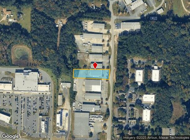
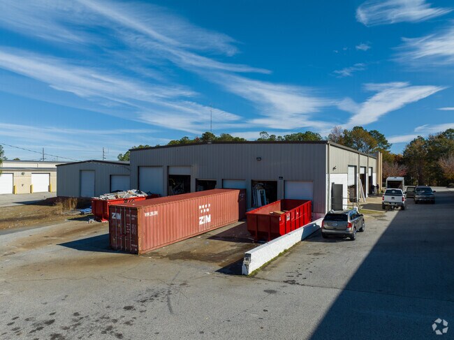
Property Record
4557 Knight Rd, Macon, GA 31220

NEARBY LISTINGS FOR SALE OR LEASE
Property Detail
4557 Knight Rd
Macon-Bibb County, GA
Tract 10
K007-0115
4557 KNIGHT RD
Warehouse
Bibb
X
Georgia
13021C0128G
4
2025
0.90 AC
2025
Outlying Bibb County
013605
Atlanta
8,820 SF
DEMOGRAPHICS near 4557 Knight Rd
1 Mile
3 Mile
5 Mile
2024 Total Population
2,032
22,938
78,234
2029 Population
1,990
22,743
77,543
Pop Growth 2024-2029
(2.07%)
(0.85%)
(0.88%)
Average Age
40
38
39
2024 Total Households
892
9,018
31,083
HH Growth 2024-2029
(2.13%)
(1.03%)
(0.97%)
Median Household Inc
$84,705
$53,777
$51,709
Avg Household Size
2.20
2.50
2.40
2024 Avg HH Vehicles
2.00
2.00
2.00
Median Home Value
$170,769
$161,774
$156,937
Median Year Built
2001
1986
1976
Nearby Places
Map Layers
Map Styles
 Street
 Aerial
- Restaurants
- Banks
- Shops
- Fitness
- Groceries
SALE & LEASE HISTORY
LISTING DATE
SALE/LEASE

Apr 02, 2025
For Lease
Nearby Properties
Address
Land Use
TOTAL SIZE
Lot Size
Zoning
Address
Land Use
TOTAL SIZE
Lot Size
Zoning
17,812 SF
161.34 AC
A/C-4
Address
Land Use
TOTAL SIZE
Lot Size
Zoning
24,207 SF
21.84 AC
PDE
Address
Land Use
TOTAL SIZE
Lot Size
Zoning
18,900 SF
25.25 AC
C-2
Address
Land Use
TOTAL SIZE
Lot Size
Zoning
170,536 SF
51.47 AC
A
Address
Land Use
TOTAL SIZE
Lot Size
Zoning
214,685 SF
18.69 AC
C-2
Address
Land Use
TOTAL SIZE
Lot Size
Zoning
20,544 SF
62.02 AC
A
Address
Land Use
TOTAL SIZE
Lot Size
Zoning
10,500 SF
12.69 AC
C-4
Address
Land Use
TOTAL SIZE
Lot Size
Zoning
2,070 SF
24.17 AC
PDR
Address
Land Use
TOTAL SIZE
Lot Size
Zoning
3,025 SF
23.37 AC
R-3
Address
Land Use
TOTAL SIZE
Lot Size
Zoning
86,912 SF
5.39 AC
PDE
Address
Land Use
TOTAL SIZE
Lot Size
Zoning
89,814 SF
16.60 AC
R-1A
Address
Land Use
TOTAL SIZE
Lot Size
Zoning
4,030 SF
11.99 AC
A
Address
Land Use
TOTAL SIZE
Lot Size
Zoning
85,556 SF
10.50 AC
R-1A
Address
Land Use
TOTAL SIZE
Lot Size
Zoning
2,766 SF
10.96 AC
R-3
Address
Land Use
TOTAL SIZE
Lot Size
Zoning
3,268 SF
9.29 AC
R-3
Address
Land Use
TOTAL SIZE
Lot Size
Zoning
123,163 SF
47.31 AC
PDE
Address
Land Use
TOTAL SIZE
Lot Size
Zoning
202,057 SF
33.05 AC
C-4
Address
Land Use
TOTAL SIZE
Lot Size
Zoning
40,560 SF
19.20 AC
R-2
Address
Land Use
TOTAL SIZE
Lot Size
Zoning
3,860 SF
22 AC
PDE
Address
Land Use
TOTAL SIZE
Lot Size
Zoning
28,755 SF
70 AC
PDE
Address
Land Use
TOTAL SIZE
Lot Size
Zoning
6,560 SF
17 AC
PDE
Address
Land Use
TOTAL SIZE
Lot Size
Zoning
69,184 SF
12.67 AC
C-2
Address
Land Use
TOTAL SIZE
Lot Size
Zoning
14,596 SF
9.45 AC
A
Address
Land Use
TOTAL SIZE
Lot Size
Zoning
105,247 SF
12.27 AC
C-2
Address
Land Use
TOTAL SIZE
Lot Size
Zoning
2,856 SF
20.50 AC
A
Address
Land Use
TOTAL SIZE
Lot Size
Zoning
132,423 SF
20.38 AC
C-2
Address
Land Use
TOTAL SIZE
Lot Size
Zoning
20,572 SF
16.08 AC
R-3
Address
Land Use
TOTAL SIZE
Lot Size
Zoning
54,810 SF
2.17 AC
C-4
Address
Land Use
TOTAL SIZE
Lot Size
Zoning
18,074 SF
7.34 AC
C-2
Address
Land Use
TOTAL SIZE
Lot Size
Zoning
76,091 SF
36.14 AC
A
The World's #1 Commercial Real Estate Marketplace
Connect with us
© 2025 CoStar Group
The information above has been obtained from sources believed reliable. While we do not doubt its accuracy we have not verified it and make no guarantee, warranty or representation about it. It is your responsibility to independently confirm its accuracy and completeness. Any projections, opinions, assumptions, or estimates used are for example only and do not represent the current or future performance of the property. The value of this transaction to you depends on tax and other factors which should be evaluated by your tax, financial, and legal advisors. You and your advisors should conduct a careful, independent investigation of the property to determine to your satisfaction the suitability of the property for your needs.