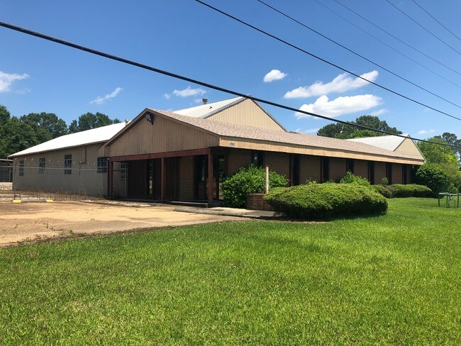
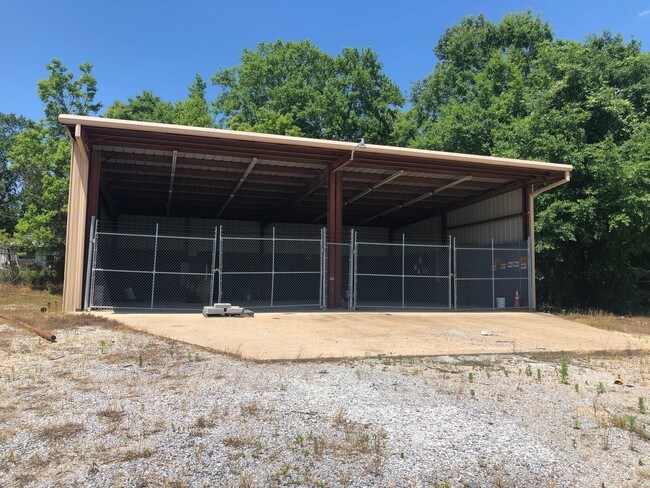
Property Record
4560 W Highway 80 W, Jackson, MS 39209

NEARBY LISTINGS FOR SALE OR LEASE
Property Detail
4560 W Highway 80 W
Jackson, MS
Van Winkle Est Pt 2
0822-0304-000
BEG 361 FT W SE COR LOT 7 W 311.7 FT NE 134.3 FT E 265 FT S 120 FT TO POB & LOT 8 N OF HWY LESS TRI NW COR TO HALL & LESS 150 X 150 FT N&S SE COR & TRI NW COR PT 9 N OF HWY BEING BEING 100 FT N/S HWY X 59.8 FT BK ON E/S IN BLK 1 VAN WINKLE EST PT 2
Wholesaleoutletdiscountstore
Hinds
X
Mississippi
28049C0292J
7,8
2024
2 AC
2025
South Jackson
010901
Jackson
7,920 SF
DEMOGRAPHICS near 4560 W Highway 80 W
1 Mile
3 Mile
5 Mile
2024 Total Population
2,333
36,452
105,069
2029 Population
2,223
35,068
100,772
Pop Growth 2024-2029
(4.71%)
(3.80%)
(4.09%)
Average Age
39
37
38
2024 Total Households
1,004
14,882
41,657
HH Growth 2024-2029
(4.88%)
(4.02%)
(4.17%)
Median Household Inc
$28,836
$29,613
$33,216
Avg Household Size
2.30
2.30
2.30
2024 Avg HH Vehicles
2.00
2.00
2.00
Median Home Value
$55,896
$64,607
$79,105
Median Year Built
1971
1969
1970
Nearby Places
Map Layers
Map Styles
 Street
 Aerial
- Restaurants
- Banks
- Shops
- Fitness
- Groceries
PUBLIC TRANSPORTATION
COMMUTER RAIL
Jackson (City of New Orleans - Amtrak)
DRIVE
WALK
Distance
Jackson (City of New Orleans - Amtrak)
8 min
4.6 mi
AIRPORT
Jackson-Medgar Wiley Evers International
DRIVE
WALK
Distance
Jackson-Medgar Wiley Evers International
25 min
15.7 mi
Freight Ports
Port of Greater Baton Rouge
DRIVE
WALK
Distance
Port of Greater Baton Rouge
200 min
178.0 mi
SALE & LEASE HISTORY
LISTING DATE
SALE/LEASE

May 22, 2019
For Sale
Nearby Properties
Address
Land Use
TOTAL SIZE
Lot Size
Zoning
Address
Land Use
TOTAL SIZE
Lot Size
Zoning
113,434 SF
82.60 AC
Address
Land Use
TOTAL SIZE
Lot Size
Zoning
191,128 SF
29.57 AC
Address
Land Use
TOTAL SIZE
Lot Size
Zoning
145,789 SF
6 AC
Address
Land Use
TOTAL SIZE
Lot Size
Zoning
192,048 SF
23.70 AC
Address
Land Use
TOTAL SIZE
Lot Size
Zoning
10,100 SF
548 AC
Address
Land Use
TOTAL SIZE
Lot Size
Zoning
545,127 SF
36 AC
Address
Land Use
TOTAL SIZE
Lot Size
Zoning
62,857 SF
4.79 AC
Address
Land Use
TOTAL SIZE
Lot Size
Zoning
41,110 SF
4.48 AC
Address
Land Use
TOTAL SIZE
Lot Size
Zoning
72,000 SF
0.01 AC
Address
Land Use
TOTAL SIZE
Lot Size
Zoning
41,616 SF
176,418.04 AC
Address
Land Use
TOTAL SIZE
Lot Size
Zoning
Address
Land Use
TOTAL SIZE
Lot Size
Zoning
108,878 SF
7.87 AC
Address
Land Use
TOTAL SIZE
Lot Size
Zoning
108,979 SF
5 AC
Address
Land Use
TOTAL SIZE
Lot Size
Zoning
199,954 SF
23 AC
Address
Land Use
TOTAL SIZE
Lot Size
Zoning
188,317 SF
23 AC
Address
Land Use
TOTAL SIZE
Lot Size
Zoning
132,342 SF
4 AC
Address
Land Use
TOTAL SIZE
Lot Size
Zoning
50,314 SF
115 AC
Address
Land Use
TOTAL SIZE
Lot Size
Zoning
Address
Land Use
TOTAL SIZE
Lot Size
Zoning
171,950 SF
9 AC
Address
Land Use
TOTAL SIZE
Lot Size
Zoning
138,086 SF
14 AC
Address
Land Use
TOTAL SIZE
Lot Size
Zoning
148,263 SF
11.26 AC
Address
Land Use
TOTAL SIZE
Lot Size
Zoning
123,390 SF
15 AC
Address
Land Use
TOTAL SIZE
Lot Size
Zoning
223,892 SF
15 AC
Address
Land Use
TOTAL SIZE
Lot Size
Zoning
16,070 SF
6 AC
Address
Land Use
TOTAL SIZE
Lot Size
Zoning
242,035 SF
15.80 AC
Address
Land Use
TOTAL SIZE
Lot Size
Zoning
11,950 SF
2 AC
Address
Land Use
TOTAL SIZE
Lot Size
Zoning
11,256 SF
3.60 AC
Address
Land Use
TOTAL SIZE
Lot Size
Zoning
7.28 AC
Address
Land Use
TOTAL SIZE
Lot Size
Zoning
253,477 SF
23 AC
Address
Land Use
TOTAL SIZE
Lot Size
Zoning
0.03 AC
The World's #1 Commercial Real Estate Marketplace
Connect with us
© 2026 CoStar Group
The information above has been obtained from sources believed reliable. While we do not doubt its accuracy we have not verified it and make no guarantee, warranty or representation about it. It is your responsibility to independently confirm its accuracy and completeness. Any projections, opinions, assumptions, or estimates used are for example only and do not represent the current or future performance of the property. The value of this transaction to you depends on tax and other factors which should be evaluated by your tax, financial, and legal advisors. You and your advisors should conduct a careful, independent investigation of the property to determine to your satisfaction the suitability of the property for your needs.