Property Record
4560 Tides Way, Shallotte, NC 28470
NEARBY LISTINGS FOR SALE OR LEASE
Property Detail
4560 Tides Way
1980001901
Survey For Caviness & Cates Boundary And
Gardenaptcourtapt5plusunits
14.99 AC PL-139/43 & 142/88
AE
Brunswick
3720109800K
North Carolina
2024
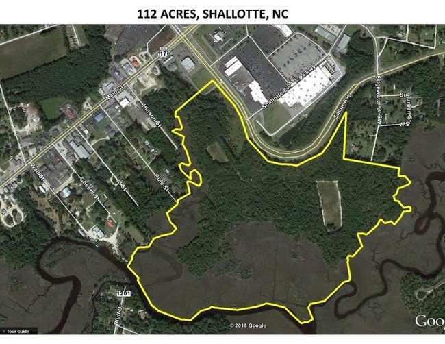
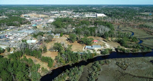
56.92 AC
2025
West Brunswick
020514
Wilmington
36,883 SF
Myrtle Beach-Conway-North Myrtle Beach, SC-NC
DEMOGRAPHICS near 4560 Tides Way
1 Mile
3 Mile
5 Mile
2024 Total Population
1,184
8,504
19,117
2029 Population
1,508
10,905
24,901
Pop Growth 2024-2029
+ 27.36%
+ 28.23%
+ 30.26%
Average Age
45
44
46
2024 Total Households
488
3,498
8,277
HH Growth 2024-2029
+ 27.05%
+ 28.07%
+ 30.35%
Median Household Inc
$55,930
$53,669
$50,960
Avg Household Size
2.30
2.30
2.20
2024 Avg HH Vehicles
2.00
2.00
2.00
Median Home Value
$230,107
$218,246
$200,039
Median Year Built
1992
1994
1994
Nearby Places
Map Layers
Map Styles
 Street
 Aerial
- Restaurants
- Banks
- Shops
- Fitness
- Groceries
SALE & LEASE HISTORY
LISTING DATE
SALE/LEASE

Sep 24, 2016
For Sale
Mar 12, 2020
For Sale
Apr 26, 2018
For Sale
Nearby Properties
Address
Land Use
TOTAL SIZE
Lot Size
Zoning
Address
Land Use
TOTAL SIZE
Lot Size
Zoning
28,548 SF
22.91 AC
CLD
Address
Land Use
TOTAL SIZE
Lot Size
Zoning
188,832 SF
54.14 AC
HB
Address
Land Use
TOTAL SIZE
Lot Size
Zoning
117,289 SF
60.11 AC
HB
Address
Land Use
TOTAL SIZE
Lot Size
Zoning
152,873 SF
22.53 AC
HB
Address
Land Use
TOTAL SIZE
Lot Size
Zoning
63,093 SF
19.15 AC
HB
Address
Land Use
TOTAL SIZE
Lot Size
Zoning
2,090 SF
11.18 AC
HB
Address
Land Use
TOTAL SIZE
Lot Size
Zoning
14,118 SF
5.20 AC
MF14
Address
Land Use
TOTAL SIZE
Lot Size
Zoning
6,596 SF
9 AC
MF14
Address
Land Use
TOTAL SIZE
Lot Size
Zoning
156,048 SF
19.88 AC
HB
Address
Land Use
TOTAL SIZE
Lot Size
Zoning
135,622 SF
16.65 AC
HB
Address
Land Use
TOTAL SIZE
Lot Size
Zoning
8,240 SF
5.59 AC
R10
Address
Land Use
TOTAL SIZE
Lot Size
Zoning
33,954 SF
4.40 AC
HB
Address
Land Use
TOTAL SIZE
Lot Size
Zoning
8,010 SF
4.55 AC
R10
Address
Land Use
TOTAL SIZE
Lot Size
Zoning
40,599 SF
25.39 AC
HB
Address
Land Use
TOTAL SIZE
Lot Size
Zoning
108,500 SF
11.59 AC
HB
Address
Land Use
TOTAL SIZE
Lot Size
Zoning
39,316 SF
10.75 AC
R15
Address
Land Use
TOTAL SIZE
Lot Size
Zoning
48,536 SF
7.70 AC
HB
Address
Land Use
TOTAL SIZE
Lot Size
Zoning
39,452 SF
6.03 AC
HB
Address
Land Use
TOTAL SIZE
Lot Size
Zoning
8,112 SF
2.15 AC
HB
Address
Land Use
TOTAL SIZE
Lot Size
Zoning
37,266 SF
40.14 AC
MF10
Address
Land Use
TOTAL SIZE
Lot Size
Zoning
27,598 SF
1.91 AC
HB
Address
Land Use
TOTAL SIZE
Lot Size
Zoning
24,646 SF
10.25 AC
HB
Address
Land Use
TOTAL SIZE
Lot Size
Zoning
4,800 SF
9.72 AC
CI
Address
Land Use
TOTAL SIZE
Lot Size
Zoning
42,817 SF
4.61 AC
MF10
Address
Land Use
TOTAL SIZE
Lot Size
Zoning
31,476 SF
3.26 AC
HB
Address
Land Use
TOTAL SIZE
Lot Size
Zoning
12,338 SF
3.19 AC
CB
Address
Land Use
TOTAL SIZE
Lot Size
Zoning
11,908 SF
5.67 AC
R15
Address
Land Use
TOTAL SIZE
Lot Size
Zoning
628.28 AC
HI
Address
Land Use
TOTAL SIZE
Lot Size
Zoning
45,000 SF
3.64 AC
HB
The World's #1 Commercial Real Estate Marketplace
Connect with us
© 2026 CoStar Group
The information above has been obtained from sources believed reliable. While we do not doubt its accuracy we have not verified it and make no guarantee, warranty or representation about it. It is your responsibility to independently confirm its accuracy and completeness. Any projections, opinions, assumptions, or estimates used are for example only and do not represent the current or future performance of the property. The value of this transaction to you depends on tax and other factors which should be evaluated by your tax, financial, and legal advisors. You and your advisors should conduct a careful, independent investigation of the property to determine to your satisfaction the suitability of the property for your needs.