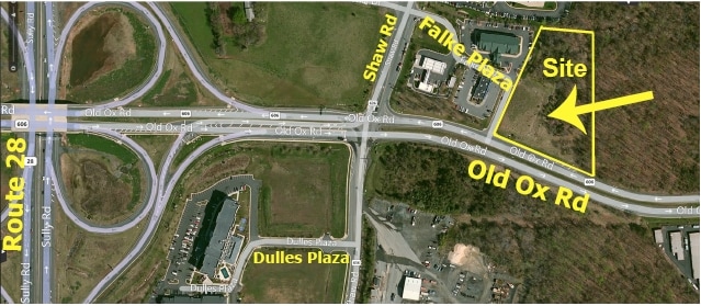
Property Record
45630 Falke Plz, Sterling, VA 20166


NEARBY LISTINGS FOR SALE OR LEASE
Property Detail
45630 Falke Plz
034-27-3975
Falke Div
Storesoffices
FALKE DIV OF LAND PARCEL C/D/F-1 202406260026306/7P ST.DEDD 1694--65, 1737--1830
X
Loudoun
51107C0385E
Virginia
2025
3.02 AC
2025
Route 28 Corridor North
611702
Washington, DC
10,428 SF
Washington-Arlington-Alexandria, DC-VA-MD-WV
DEMOGRAPHICS near 45630 Falke Plz
1 Mile
3 Mile
5 Mile
2024 Total Population
5,565
91,300
247,923
2029 Population
5,678
92,808
255,225
Pop Growth 2024-2029
+ 2.03%
+ 1.65%
+ 2.95%
Average Age
35
36
38
2024 Total Households
1,767
31,219
90,458
HH Growth 2024-2029
+ 1.92%
+ 1.70%
+ 2.90%
Median Household Inc
$139,574
$122,922
$132,330
Avg Household Size
3.10
2.80
2.70
2024 Avg HH Vehicles
2.00
2.00
2.00
Median Home Value
$572,306
$515,009
$624,243
Median Year Built
1998
1991
1992
Nearby Places
Map Layers
Map Styles
 Street
 Aerial
- Restaurants
- Banks
- Shops
- Fitness
- Groceries
Nearby Properties
Address
Land Use
TOTAL SIZE
Lot Size
Zoning
Address
Land Use
TOTAL SIZE
Lot Size
Zoning
2,700,000 SF
7.51 AC
PDGI
Address
Land Use
TOTAL SIZE
Lot Size
Zoning
800,702 SF
111.70 AC
PDIP
Address
Land Use
TOTAL SIZE
Lot Size
Zoning
789,350 SF
31.73 AC
PDOP
Address
Land Use
TOTAL SIZE
Lot Size
Zoning
234,124 SF
23.84 AC
PDOP
Address
Land Use
TOTAL SIZE
Lot Size
Zoning
427,320 SF
16.33 AC
PDIP
Address
Land Use
TOTAL SIZE
Lot Size
Zoning
364,600 SF
PDOP
Address
Land Use
TOTAL SIZE
Lot Size
Zoning
308,630 SF
14.44 AC
PDIP
Address
Land Use
TOTAL SIZE
Lot Size
Zoning
147,260 SF
33.04 AC
PDIP
Address
Land Use
TOTAL SIZE
Lot Size
Zoning
565,680 SF
18.44 AC
PDIP
Address
Land Use
TOTAL SIZE
Lot Size
Zoning
228,606 SF
PDOP
Address
Land Use
TOTAL SIZE
Lot Size
Zoning
180,355 SF
12.89 AC
PDIP
Address
Land Use
TOTAL SIZE
Lot Size
Zoning
764,166 SF
73.90 AC
PDIP
Address
Land Use
TOTAL SIZE
Lot Size
Zoning
226,456 SF
17.09 AC
PDIP
Address
Land Use
TOTAL SIZE
Lot Size
Zoning
154,125 SF
9.68 AC
PDIP
Address
Land Use
TOTAL SIZE
Lot Size
Zoning
364,650 SF
PDOP
Address
Land Use
TOTAL SIZE
Lot Size
Zoning
253,352 SF
PDOP
Address
Land Use
TOTAL SIZE
Lot Size
Zoning
252,473 SF
9.03 AC
PDIP
Address
Land Use
TOTAL SIZE
Lot Size
Zoning
405,058 SF
19.88 AC
IP
Address
Land Use
TOTAL SIZE
Lot Size
Zoning
120,240 SF
12.15 AC
PDIP
Address
Land Use
TOTAL SIZE
Lot Size
Zoning
585,593 SF
15.38 AC
PDOP
Address
Land Use
TOTAL SIZE
Lot Size
Zoning
180,039 SF
15.98 AC
PDOP
Address
Land Use
TOTAL SIZE
Lot Size
Zoning
128,500 SF
9.95 AC
PDIP
Address
Land Use
TOTAL SIZE
Lot Size
Zoning
272,876 SF
50 AC
PDOP
Address
Land Use
TOTAL SIZE
Lot Size
Zoning
263,340 SF
79.61 AC
GI
Address
Land Use
TOTAL SIZE
Lot Size
Zoning
425,073 SF
19.02 AC
330
Address
Land Use
TOTAL SIZE
Lot Size
Zoning
357,437 SF
3.76 AC
350
Address
Land Use
TOTAL SIZE
Lot Size
Zoning
429,038 SF
11.41 AC
400
Address
Land Use
TOTAL SIZE
Lot Size
Zoning
396,112 SF
15.92 AC
330
Address
Land Use
TOTAL SIZE
Lot Size
Zoning
490,340 SF
18.30 AC
320
Address
Land Use
TOTAL SIZE
Lot Size
Zoning
306,224 SF
10.14 AC
R1
The World's #1 Commercial Real Estate Marketplace
Connect with us
© 2025 CoStar Group
The information above has been obtained from sources believed reliable. While we do not doubt its accuracy we have not verified it and make no guarantee, warranty or representation about it. It is your responsibility to independently confirm its accuracy and completeness. Any projections, opinions, assumptions, or estimates used are for example only and do not represent the current or future performance of the property. The value of this transaction to you depends on tax and other factors which should be evaluated by your tax, financial, and legal advisors. You and your advisors should conduct a careful, independent investigation of the property to determine to your satisfaction the suitability of the property for your needs.