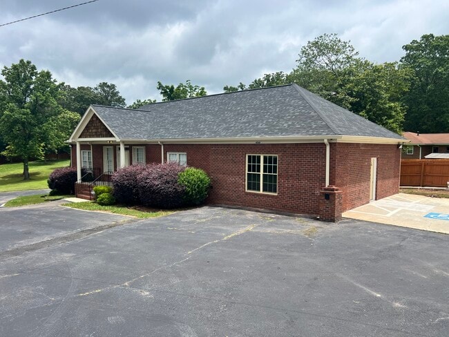
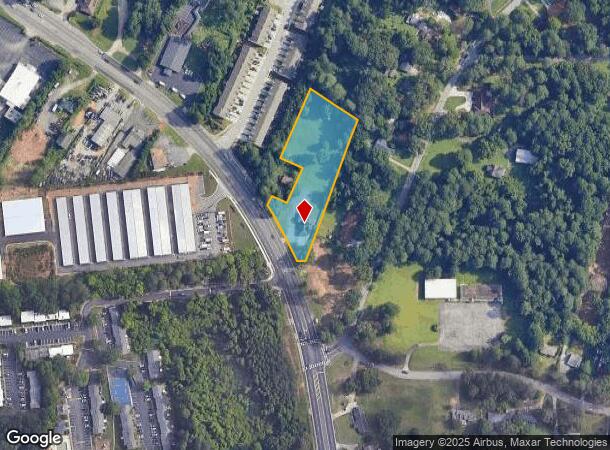
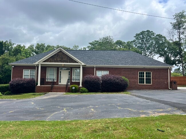
Property Record
4568 Covington Hwy, Decatur, GA 30035
NEARBY LISTINGS FOR SALE OR LEASE
Property Detail
4568 Covington Hwy
Atlanta-Sandy Springs-Roswell, GA
Not Shown
15-190-02-013
90 X 490 X 90 X 490 X 41 1.01AC 3-29-9
Officebuilding
DeKalb
X
Georgia
13089C0151J
13
2025
1.72 AC
2025
Stone Mountain
023215
Atlanta
1,850 SF
DEMOGRAPHICS near 4568 Covington Hwy
1 Mile
3 Mile
5 Mile
2024 Total Population
7,709
89,520
263,455
2029 Population
7,690
89,243
262,738
Pop Growth 2024-2029
(0.25%)
(0.31%)
(0.27%)
Average Age
40
40
39
2024 Total Households
2,972
33,823
99,975
HH Growth 2024-2029
(0.20%)
(0.17%)
(0.19%)
Median Household Inc
$43,546
$51,481
$57,936
Avg Household Size
2.60
2.50
2.50
2024 Avg HH Vehicles
1.00
2.00
2.00
Median Home Value
$150,746
$195,420
$223,719
Median Year Built
1976
1976
1979
Nearby Places
Map Layers
Map Styles
 Street
 Aerial
- Restaurants
- Banks
- Shops
- Fitness
- Groceries
PUBLIC TRANSPORTATION
AIRPORT
Hartsfield - Jackson Atlanta International
DRIVE
WALK
Distance
Hartsfield - Jackson Atlanta International
26 min
16.6 mi
SALE & LEASE HISTORY
LISTING DATE
SALE/LEASE

Sep 27, 2017
For Lease
Oct 25, 2023
For Lease
Apr 10, 2018
For Sale
Nearby Properties
Address
Land Use
TOTAL SIZE
Lot Size
Zoning
Address
Land Use
TOTAL SIZE
Lot Size
Zoning
78,008 SF
11.16 AC
HR-3
Address
Land Use
TOTAL SIZE
Lot Size
Zoning
988,394 SF
102.84 AC
RM100
Address
Land Use
TOTAL SIZE
Lot Size
Zoning
834,629 SF
59.49 AC
RM100
Address
Land Use
TOTAL SIZE
Lot Size
Zoning
287,674 SF
17.63 AC
R75: SF RE
Address
Land Use
TOTAL SIZE
Lot Size
Zoning
350,556 SF
46.09 AC
X
Address
Land Use
TOTAL SIZE
Lot Size
Zoning
455,599 SF
43.15 AC
HR-3
Address
Land Use
TOTAL SIZE
Lot Size
Zoning
295,718 SF
25.64 AC
RM85
Address
Land Use
TOTAL SIZE
Lot Size
Zoning
76,500 SF
2.84 AC
X
Address
Land Use
TOTAL SIZE
Lot Size
Zoning
251,327 SF
19.92 AC
X
Address
Land Use
TOTAL SIZE
Lot Size
Zoning
396,905 SF
20.82 AC
RM85
Address
Land Use
TOTAL SIZE
Lot Size
Zoning
71,208 SF
15 AC
X
Address
Land Use
TOTAL SIZE
Lot Size
Zoning
292,395 SF
19.65 AC
RM100
Address
Land Use
TOTAL SIZE
Lot Size
Zoning
253,740 SF
13.33 AC
RM75
Address
Land Use
TOTAL SIZE
Lot Size
Zoning
158,939 SF
14.09 AC
RM85
Address
Land Use
TOTAL SIZE
Lot Size
Zoning
256,445 SF
11.71 AC
RM85
Address
Land Use
TOTAL SIZE
Lot Size
Zoning
209,022 SF
16.22 AC
RM100
Address
Land Use
TOTAL SIZE
Lot Size
Zoning
814,943 SF
40.83 AC
M
Address
Land Use
TOTAL SIZE
Lot Size
Zoning
249,668 SF
16.76 AC
RM100
Address
Land Use
TOTAL SIZE
Lot Size
Zoning
221,594 SF
15.90 AC
RM85
Address
Land Use
TOTAL SIZE
Lot Size
Zoning
23,072 SF
5.48 AC
C1
Address
Land Use
TOTAL SIZE
Lot Size
Zoning
118,371 SF
15 AC
R75
Address
Land Use
TOTAL SIZE
Lot Size
Zoning
300,697 SF
21.18 AC
RM85
Address
Land Use
TOTAL SIZE
Lot Size
Zoning
277,816 SF
18.15 AC
RM100
Address
Land Use
TOTAL SIZE
Lot Size
Zoning
183,598 SF
18.88 AC
X
Address
Land Use
TOTAL SIZE
Lot Size
Zoning
217,904 SF
14.84 AC
Address
Land Use
TOTAL SIZE
Lot Size
Zoning
182,490 SF
12.46 AC
RM100
Address
Land Use
TOTAL SIZE
Lot Size
Zoning
24,500 SF
4.24 AC
X
Address
Land Use
TOTAL SIZE
Lot Size
Zoning
175,082 SF
14.87 AC
X
Address
Land Use
TOTAL SIZE
Lot Size
Zoning
210,070 SF
14.81 AC
RM100
Address
Land Use
TOTAL SIZE
Lot Size
Zoning
201,552 SF
24.63 AC
C1: LOCAL
The World's #1 Commercial Real Estate Marketplace
Connect with us
© 2025 CoStar Group
The information above has been obtained from sources believed reliable. While we do not doubt its accuracy we have not verified it and make no guarantee, warranty or representation about it. It is your responsibility to independently confirm its accuracy and completeness. Any projections, opinions, assumptions, or estimates used are for example only and do not represent the current or future performance of the property. The value of this transaction to you depends on tax and other factors which should be evaluated by your tax, financial, and legal advisors. You and your advisors should conduct a careful, independent investigation of the property to determine to your satisfaction the suitability of the property for your needs.