Property Record
4568 Cumming Hwy, Canton, GA 30115
NEARBY LISTINGS FOR SALE OR LEASE
-
-
View all Canton listings for sale on LoopNet.com
Property Detail
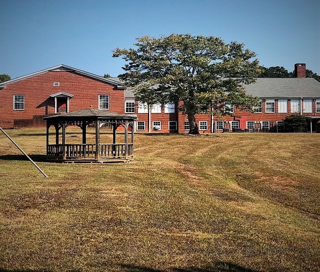
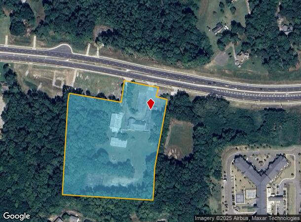
4568 Cumming Hwy
003N05-00000-013-000-0000
BUFFINGTON ELEM SCHOOL
Publicschool
Cherokee
X
Georgia
13057C0260E
9.88 AC
0
Cherokee County
2025
Atlanta
090603
Atlanta-Sandy Springs-Roswell, GA
30,557 SF
DEMOGRAPHICS near 4568 Cumming Hwy
1 Mile
3 Mile
5 Mile
2024 Total Population
1,779
11,858
54,237
2029 Population
2,052
13,511
62,188
Pop Growth 2024-2029
+ 15.35%
+ 13.94%
+ 14.66%
Average Age
41
41
39
2024 Total Households
609
4,049
18,455
HH Growth 2024-2029
+ 15.44%
+ 14.10%
+ 14.83%
Median Household Inc
$116,105
$109,740
$95,014
Avg Household Size
2.90
2.90
2.80
2024 Avg HH Vehicles
2.00
2.00
2.00
Median Home Value
$392,072
$413,196
$391,883
Median Year Built
2002
2002
2001
Nearby Places
- Restaurants
- Banks
- Shops
- Fitness
- Groceries
SALE & LEASE HISTORY
LISTING DATE
SALE/LEASE

Oct 07, 2019
For Sale
Nearby Properties
Address
Land Use
TOTAL SIZE
Lot Size
Zoning
Address
Land Use
TOTAL SIZE
Lot Size
Zoning
242,502 SF
41.65 AC
PD
Address
Land Use
TOTAL SIZE
Lot Size
Zoning
313,906 SF
28.96 AC
PD
Address
Land Use
TOTAL SIZE
Lot Size
Zoning
204,826 SF
4.91 AC
PD
Address
Land Use
TOTAL SIZE
Lot Size
Zoning
24,586 SF
PD
Address
Land Use
TOTAL SIZE
Lot Size
Zoning
178,576 SF
13.74 AC
GC
Address
Land Use
TOTAL SIZE
Lot Size
Zoning
191,105 SF
12.37 AC
PD
Address
Land Use
TOTAL SIZE
Lot Size
Zoning
151,121 SF
33.37 AC
GC
Address
Land Use
TOTAL SIZE
Lot Size
Zoning
133,843 SF
31.69 AC
AG
Address
Land Use
TOTAL SIZE
Lot Size
Zoning
196,718 SF
32.59 AC
GC
Address
Land Use
TOTAL SIZE
Lot Size
Zoning
139,274 SF
12.34 AC
PD
Address
Land Use
TOTAL SIZE
Lot Size
Zoning
107.28 AC
PD
Address
Land Use
TOTAL SIZE
Lot Size
Zoning
58.97 AC
OI
Address
Land Use
TOTAL SIZE
Lot Size
Zoning
69,966 SF
22.62 AC
GC
Address
Land Use
TOTAL SIZE
Lot Size
Zoning
54.76 AC
PD
Address
Land Use
TOTAL SIZE
Lot Size
Zoning
86,913 SF
6.47 AC
PD
Address
Land Use
TOTAL SIZE
Lot Size
Zoning
39,657 SF
149.32 AC
AG
Address
Land Use
TOTAL SIZE
Lot Size
Zoning
85,610 SF
9.76 AC
GC
Address
Land Use
TOTAL SIZE
Lot Size
Zoning
246.49 AC
PUD
Address
Land Use
TOTAL SIZE
Lot Size
Zoning
52,895 SF
4.02 AC
GC
Address
Land Use
TOTAL SIZE
Lot Size
Zoning
960 SF
78.30 AC
R-15
Address
Land Use
TOTAL SIZE
Lot Size
Zoning
13,966 SF
1.56 AC
GC
Address
Land Use
TOTAL SIZE
Lot Size
Zoning
8,133 SF
1.14 AC
GC
Address
Land Use
TOTAL SIZE
Lot Size
Zoning
28,000 SF
3.64 AC
GC
Address
Land Use
TOTAL SIZE
Lot Size
Zoning
8,856 SF
0.97 AC
NC
Address
Land Use
TOTAL SIZE
Lot Size
Zoning
20 AC
PD
Address
Land Use
TOTAL SIZE
Lot Size
Zoning
12,024 SF
2.30 AC
GC
Address
Land Use
TOTAL SIZE
Lot Size
Zoning
10,120 SF
1.25 AC
O-I
Address
Land Use
TOTAL SIZE
Lot Size
Zoning
1,462 SF
8.74 AC
NC
Address
Land Use
TOTAL SIZE
Lot Size
Zoning
6,042 SF
2.63 AC
GC
Address
Land Use
TOTAL SIZE
Lot Size
Zoning
134.91 AC
AG
The World's #1 Commercial Real Estate Marketplace
Connect with us
© 2025 CoStar Group
The information above has been obtained from sources believed reliable. While we do not doubt its accuracy we have not verified it and make no guarantee, warranty or representation about it. It is your responsibility to independently confirm its accuracy and completeness. Any projections, opinions, assumptions, or estimates used are for example only and do not represent the current or future performance of the property. The value of this transaction to you depends on tax and other factors which should be evaluated by your tax, financial, and legal advisors. You and your advisors should conduct a careful, independent investigation of the property to determine to your satisfaction the suitability of the property for your needs.