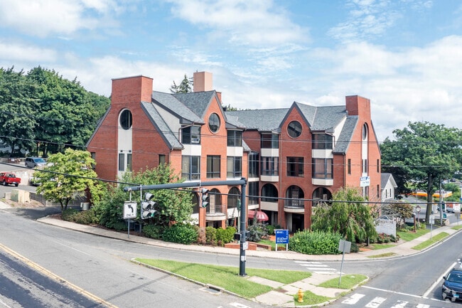
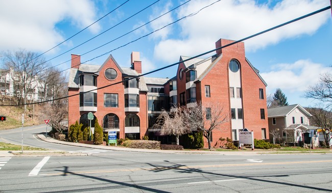
Property Record
457 N Main St, Danbury, CT 06811
Current Lease Availabilities
NEARBY LISTINGS FOR SALE OR LEASE
Property Detail
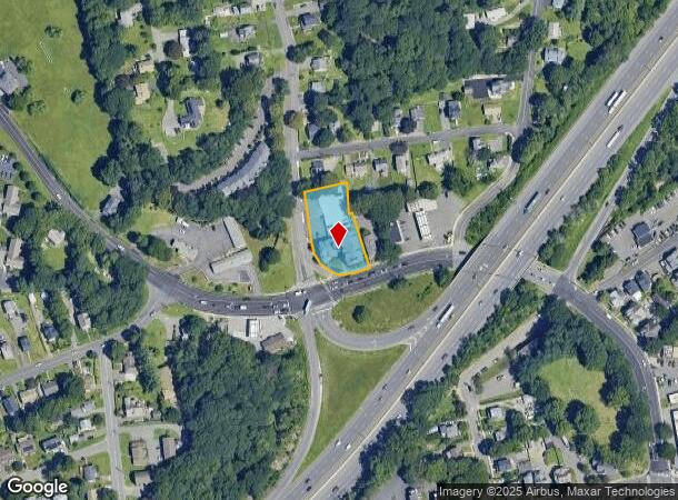
457 N Main St
DANB-000012H-000000-000074
Fairfield
Commercialnec
Connecticut
X
74
09001C0139F
0.67 AC
2025
Danbury
2025
Westchester/So Connecticut
211000
Bridgeport-Stamford-Danbury, CT
DEMOGRAPHICS near 457 N Main St
1 mile
3 mile
5 mile
2024 Total Population
18,267
73,335
118,204
2029 Population
18,033
72,718
117,861
Pop Growth 2024-2029
(1.28%)
(0.84%)
(0.29%)
Average Age
36
39
40
2024 Total Households
6,240
26,256
43,390
HH Growth 2024-2029
(1.38%)
(0.98%)
(0.36%)
Median Household Inc
$66,844
$72,807
$87,622
Avg Household Size
2.70
2.60
2.60
2024 Avg HH Vehicles
2.00
2.00
2.00
Median Home Value
$292,805
$330,748
$361,513
Median Year Built
1965
1972
1973
Nearby Places
Map Layers
Map Styles
 Street
 Aerial
Transit
 Traffic
 Biking
Places
Listings with unknown addresses are not visible on the map
- Restaurants
- Banks
- Shops
- Fitness
- Groceries
PUBLIC TRANSPORTATION
COMMUTER RAIL
Danbury Station (New Haven Line - Metro-North Commuter Railroad Company (Metro-North))
Drive
Walk
Distance
Danbury Station (New Haven Line - Metro-North Commuter Railroad Company (Metro-North))
4 min
1.6 mi
Bethel Station (New Haven Line - Metro-North Commuter Railroad Company (Metro-North))
Drive
Walk
Distance
Bethel Station (New Haven Line - Metro-North Commuter Railroad Company (Metro-North))
10 min
4.0 mi
AIRPORT
Westchester County
Drive
Walk
Distance
Westchester County
43 min
34.0 mi
Freight Ports
Port of New Haven
Drive
Walk
Distance
Port of New Haven
54 min
36.4 mi
Nearby Properties
Address
Land Use
TOTAL SIZE
Lot Size
Zoning
Address
Land Use
TOTAL SIZE
Lot Size
Zoning
69.58 AC
CG20
Address
Land Use
TOTAL SIZE
Lot Size
Zoning
9.04 AC
CCBD
Address
Land Use
TOTAL SIZE
Lot Size
Zoning
54.91 AC
RA40
Address
Land Use
TOTAL SIZE
Lot Size
Zoning
56.59 AC
IL40
Address
Land Use
TOTAL SIZE
Lot Size
Zoning
297,318 SF
18.16 AC
IG80
Address
Land Use
TOTAL SIZE
Lot Size
Zoning
135.19 AC
IL40
Address
Land Use
TOTAL SIZE
Lot Size
Zoning
7.98 AC
RH3
Address
Land Use
TOTAL SIZE
Lot Size
Zoning
7,769 SF
17.75 AC
RA-20
Address
Land Use
TOTAL SIZE
Lot Size
Zoning
36.22 AC
RA-20
Address
Land Use
TOTAL SIZE
Lot Size
Zoning
13.70 AC
RA-20
Address
Land Use
TOTAL SIZE
Lot Size
Zoning
18.63 AC
CG20
Address
Land Use
TOTAL SIZE
Lot Size
Zoning
33.50 AC
CG-20
Address
Land Use
TOTAL SIZE
Lot Size
Zoning
95,976 SF
4.14 AC
RH3
Address
Land Use
TOTAL SIZE
Lot Size
Zoning
273,127 SF
10.33 AC
RA-40
Address
Land Use
TOTAL SIZE
Lot Size
Zoning
10.51 AC
RMF-4
Address
Land Use
TOTAL SIZE
Lot Size
Zoning
31 AC
RMF4
Address
Land Use
TOTAL SIZE
Lot Size
Zoning
165,840 SF
9.49 AC
CG20
Address
Land Use
TOTAL SIZE
Lot Size
Zoning
478,816 SF
39.59 AC
IL40
Address
Land Use
TOTAL SIZE
Lot Size
Zoning
137,884 SF
16.96 AC
1L40
Address
Land Use
TOTAL SIZE
Lot Size
Zoning
42.36 AC
R-3
Address
Land Use
TOTAL SIZE
Lot Size
Zoning
158,981 SF
12.79 AC
RA20
Address
Land Use
TOTAL SIZE
Lot Size
Zoning
45.78 AC
RM12
Address
Land Use
TOTAL SIZE
Lot Size
Zoning
7.28 AC
RH3
Address
Land Use
TOTAL SIZE
Lot Size
Zoning
47,564 SF
4.45 AC
CCBD
Address
Land Use
TOTAL SIZE
Lot Size
Zoning
10 AC
CG-20
Address
Land Use
TOTAL SIZE
Lot Size
Zoning
17.24 AC
IL-40
Address
Land Use
TOTAL SIZE
Lot Size
Zoning
198,560 SF
3.30 AC
CLCB
Address
Land Use
TOTAL SIZE
Lot Size
Zoning
10.51 AC
IL40
Address
Land Use
TOTAL SIZE
Lot Size
Zoning
12.51 AC
IL40
Address
Land Use
TOTAL SIZE
Lot Size
Zoning
133,936 SF
5.61 AC
IL40
The World's #1 Commercial Real Estate Marketplace
Connect with us
© 2026 CoStar Group
The information above has been obtained from sources believed reliable. While we do not doubt its accuracy we have not verified it and make no guarantee, warranty or representation about it. It is your responsibility to independently confirm its accuracy and completeness. Any projections, opinions, assumptions, or estimates used are for example only and do not represent the current or future performance of the property. The value of this transaction to you depends on tax and other factors which should be evaluated by your tax, financial, and legal advisors. You and your advisors should conduct a careful, independent investigation of the property to determine to your satisfaction the suitability of the property for your needs.