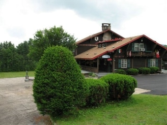
Property Record
457 Nh Route 16A, Intervale, NH 03845

Save to a Folder
{{folder.Name}}
{{folder.ListingIds.length}} Properties
{{folder.ListingIds.length}} Property
Create a New Folder
Property Detail
457 Nh Route 16A
Commercialnec
CARROLL
TOWN R
New Hampshire
B and X Area of moderate flood hazard, usually the area between the limits of the 100-year and 500-year floods.
227
2024
12 AC
2024
Concord/New Hampshire North Area
955102
Other Market Areas
7,560 SF
BART-000116R-T000000A-L000227
NEARBY LISTINGS FOR SALE OR LEASE
-
-
View all Intervale listings for sale on LoopNet.com
DEMOGRAPHICS near 457 Nh Route 16A
1 mile
3 mile
5 mile
2025 Total Population
475
2,239
5,018
2030 Population
444
2,090
4,775
Pop Growth 2025-2030
(6.53%)
(6.65%)
(4.84%)
Average Age
50
51
50
2025 Total Households
238
1,088
2,420
HH Growth 2025-2030
(6.72%)
(6.89%)
(5.08%)
Median Household Inc
$77,941
$80,628
$76,056
Avg Household Size
2.00
2.00
2.00
2025 Avg HH Vehicles
2.00
2.00
2.00
Median Home Value
$416,860
$441,262
$450,641
Median Year Built
1981
1982
1982
Nearby Places
Map Layers
Map Styles
 Street
 Aerial
Layers
 Traffic
 Biking
Places
Listings with unknown addresses are not visible on the map
- Restaurants
- Banks
- Shops
- Fitness
- Groceries
Nearby Properties
Address
Land Use
TOTAL SIZE
Lot Size
Zoning
Address
Land Use
TOTAL SIZE
Lot Size
Zoning
5,344 SF
102 AC
TOWN C
Address
Land Use
TOTAL SIZE
Lot Size
Zoning
4,119 SF
69.50 AC
TOWN C
Address
Land Use
TOTAL SIZE
Lot Size
Zoning
5.59 AC
COMMER
Address
Land Use
TOTAL SIZE
Lot Size
Zoning
47.61 AC
RURAL
Address
Land Use
TOTAL SIZE
Lot Size
Zoning
20,106 SF
23 AC
COMMER
Address
Land Use
TOTAL SIZE
Lot Size
Zoning
34 AC
COMMER
Address
Land Use
TOTAL SIZE
Lot Size
Zoning
10,441 SF
5.99 AC
TOWN C
Address
Land Use
TOTAL SIZE
Lot Size
Zoning
17,908 SF
6.50 AC
TOWN R
Address
Land Use
TOTAL SIZE
Lot Size
Zoning
2,149 SF
2.16 AC
HC
Address
Land Use
TOTAL SIZE
Lot Size
Zoning
1,200 SF
4.70 AC
TOWN C
Address
Land Use
TOTAL SIZE
Lot Size
Zoning
2,995 SF
90 AC
RURAL
Address
Land Use
TOTAL SIZE
Lot Size
Zoning
1.70 AC
HC
Address
Land Use
TOTAL SIZE
Lot Size
Zoning
1.50 AC
HC
Address
Land Use
TOTAL SIZE
Lot Size
Zoning
3.61 AC
HC
Address
Land Use
TOTAL SIZE
Lot Size
Zoning
672 SF
175.90 AC
TOWN C
Address
Land Use
TOTAL SIZE
Lot Size
Zoning
517.50 AC
TOWN N
Address
Land Use
TOTAL SIZE
Lot Size
Zoning
6,965 SF
7.07 AC
TOWN R
Address
Land Use
TOTAL SIZE
Lot Size
Zoning
Address
Land Use
TOTAL SIZE
Lot Size
Zoning
8,779 SF
1.72 AC
TOWN R
Address
Land Use
TOTAL SIZE
Lot Size
Zoning
11.39 AC
RURAL
Address
Land Use
TOTAL SIZE
Lot Size
Zoning
19,730 SF
3.49 AC
TOWN C
Address
Land Use
TOTAL SIZE
Lot Size
Zoning
1,467 SF
24.89 AC
TOWN C
Address
Land Use
TOTAL SIZE
Lot Size
Zoning
6.35 AC
HC
Address
Land Use
TOTAL SIZE
Lot Size
Zoning
7,937 SF
2 AC
TOWN R
Address
Land Use
TOTAL SIZE
Lot Size
Zoning
10,929 SF
2.20 AC
COMMER
Address
Land Use
TOTAL SIZE
Lot Size
Zoning
7,258 SF
3.90 AC
TOWN C
Address
Land Use
TOTAL SIZE
Lot Size
Zoning
14,726 SF
4 AC
TOWN C
Address
Land Use
TOTAL SIZE
Lot Size
Zoning
16,335 SF
1.78 AC
TOWN C
Address
Land Use
TOTAL SIZE
Lot Size
Zoning
9,555 SF
5.99 AC
TOWN C
The World's #1 Commercial Real Estate Marketplace
Connect with us
© 2026 CoStar Group
The information above has been obtained from sources believed reliable. While we do not doubt its accuracy we have not verified it and make no guarantee, warranty or representation about it. It is your responsibility to independently confirm its accuracy and completeness. Any projections, opinions, assumptions, or estimates used are for example only and do not represent the current or future performance of the property. The value of this transaction to you depends on tax and other factors which should be evaluated by your tax, financial, and legal advisors. You and your advisors should conduct a careful, independent investigation of the property to determine to your satisfaction the suitability of the property for your needs.