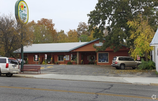
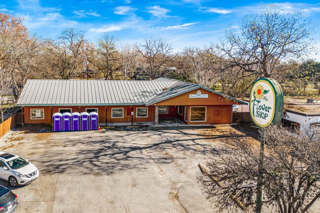
Property Record
457 S Main St, Boerne, TX 78006

Property Detail
457 S Main St
San Antonio-New Braunfels, TX
BOERNE ORIGINAL TOWN LOT PT 1, 0.191 ACRES
19823
KENDALL
Commercialbuilding
Texas
C and X Area of minimal flood hazard, usually depicted on FIRMs as above the 500-year flood level.
1
2024
0.19 AC
2025
Kendall County
970404
San Antonio
NEARBY LISTINGS FOR SALE OR LEASE
DEMOGRAPHICS near 457 S Main St
1 mile
3 mile
5 mile
2025 Total Population
8,753
27,373
34,934
2030 Population
9,881
30,950
39,512
Pop Growth 2025-2030
+ 12.89%
+ 13.07%
+ 13.10%
Average Age
42
42
42
2025 Total Households
3,464
10,157
12,924
HH Growth 2025-2030
+ 12.99%
+ 13.18%
+ 13.23%
Median Household Inc
$61,431
$93,147
$102,825
Avg Household Size
2.40
2.60
2.60
2025 Avg HH Vehicles
2.00
2.00
2.00
Median Home Value
$460,237
$482,922
$500,147
Median Year Built
1995
2003
2004
Nearby Places
Map Layers
Map Styles
 Street
 Aerial
Layers
 Traffic
 Biking
Places
Listings with unknown addresses are not visible on the map
- Restaurants
- Banks
- Shops
- Fitness
- Groceries
PUBLIC TRANSPORTATION
AIRPORT
San Antonio International
Drive
Walk
Distance
San Antonio International
37 min
29.4 mi
SALE & LEASE HISTORY
LISTING DATE
SALE/LEASE

Jul 23, 2018
For Sale
Dec 08, 2019
For Sale
Aug 30, 2017
For Lease
Aug 08, 2018
For Sale
Apr 18, 2017
For Lease
Nearby Properties
Address
Land Use
TOTAL SIZE
Lot Size
Zoning
Address
Land Use
TOTAL SIZE
Lot Size
Zoning
315,748 SF
102.19 AC
Address
Land Use
TOTAL SIZE
Lot Size
Zoning
236,676 SF
55.67 AC
Address
Land Use
TOTAL SIZE
Lot Size
Zoning
384,453 SF
34.24 AC
Address
Land Use
TOTAL SIZE
Lot Size
Zoning
252,468 SF
56.42 AC
Address
Land Use
TOTAL SIZE
Lot Size
Zoning
135,904 SF
10.40 AC
Address
Land Use
TOTAL SIZE
Lot Size
Zoning
86,050 SF
25.59 AC
Address
Land Use
TOTAL SIZE
Lot Size
Zoning
78,586 SF
15.36 AC
Address
Land Use
TOTAL SIZE
Lot Size
Zoning
111,517 SF
20.86 AC
Address
Land Use
TOTAL SIZE
Lot Size
Zoning
91,430 SF
3.99 AC
Address
Land Use
TOTAL SIZE
Lot Size
Zoning
90,958 SF
19.64 AC
Address
Land Use
TOTAL SIZE
Lot Size
Zoning
247,144 SF
17.49 AC
Address
Land Use
TOTAL SIZE
Lot Size
Zoning
83,845 SF
7.32 AC
Address
Land Use
TOTAL SIZE
Lot Size
Zoning
215,475 SF
13.14 AC
Address
Land Use
TOTAL SIZE
Lot Size
Zoning
257,805 SF
15.54 AC
Address
Land Use
TOTAL SIZE
Lot Size
Zoning
185,555 SF
11.76 AC
Address
Land Use
TOTAL SIZE
Lot Size
Zoning
43,470 SF
1.77 AC
Address
Land Use
TOTAL SIZE
Lot Size
Zoning
38,159 SF
9.91 AC
Address
Land Use
TOTAL SIZE
Lot Size
Zoning
94,142 SF
40.34 AC
Address
Land Use
TOTAL SIZE
Lot Size
Zoning
80,546 SF
4.66 AC
Address
Land Use
TOTAL SIZE
Lot Size
Zoning
1,924 SF
103.24 AC
Address
Land Use
TOTAL SIZE
Lot Size
Zoning
185,852 SF
22.38 AC
Address
Land Use
TOTAL SIZE
Lot Size
Zoning
70,036 SF
0.77 AC
Address
Land Use
TOTAL SIZE
Lot Size
Zoning
57,717 SF
3.78 AC
Address
Land Use
TOTAL SIZE
Lot Size
Zoning
54,854 SF
4.44 AC
Address
Land Use
TOTAL SIZE
Lot Size
Zoning
86,137 SF
Address
Land Use
TOTAL SIZE
Lot Size
Zoning
119,256 SF
12.59 AC
Address
Land Use
TOTAL SIZE
Lot Size
Zoning
8,515 SF
59.67 AC
Address
Land Use
TOTAL SIZE
Lot Size
Zoning
42,101 SF
6.03 AC
Address
Land Use
TOTAL SIZE
Lot Size
Zoning
128,730 SF
Address
Land Use
TOTAL SIZE
Lot Size
Zoning
60,750 SF
15.53 AC
The World's #1 Commercial Real Estate Marketplace
Connect with us
© 2026 CoStar Group
The information above has been obtained from sources believed reliable. While we do not doubt its accuracy we have not verified it and make no guarantee, warranty or representation about it. It is your responsibility to independently confirm its accuracy and completeness. Any projections, opinions, assumptions, or estimates used are for example only and do not represent the current or future performance of the property. The value of this transaction to you depends on tax and other factors which should be evaluated by your tax, financial, and legal advisors. You and your advisors should conduct a careful, independent investigation of the property to determine to your satisfaction the suitability of the property for your needs.