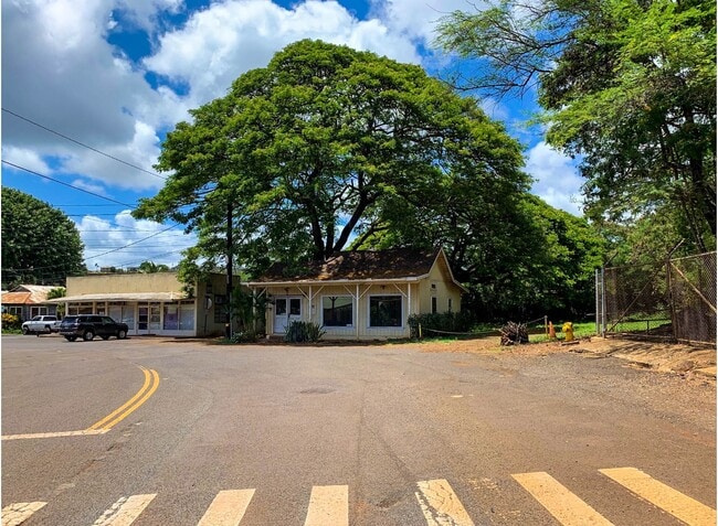
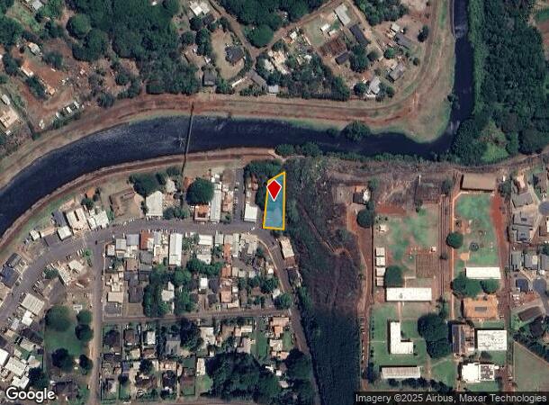
Property Record
4570 Ko Rd, Hanapepe, HI 96716
NEARBY LISTINGS FOR SALE OR LEASE
-
-
View all Hanapepe listings for sale on LoopNet.com
Property Detail
4570 Ko Rd
Kapaa, HI
Hanapepe Town Lts
4-1-9-004-001-0000
LOT 8 HANAPEPE TOWN LOTS 15,006 SF DES
Commercialnec
Kauai
AE
Hawaii
1500020287G
8
2024
0.35 AC
2025
Kauai
040800
Hawaii
1,808 SF
DEMOGRAPHICS near 4570 Ko Rd
1 Mile
3 Mile
5 Mile
2024 Total Population
4,216
4,216
8,983
2029 Population
4,239
4,239
8,816
Pop Growth 2024-2029
+ 0.55%
+ 0.55%
(1.86%)
Average Age
41
41
43
2024 Total Households
1,288
1,288
2,978
HH Growth 2024-2029
+ 0.39%
+ 0.39%
(2.22%)
Median Household Inc
$91,935
$91,935
$88,284
Avg Household Size
3.20
3.20
3.00
2024 Avg HH Vehicles
3.00
3.00
3.00
Median Home Value
$663,570
$663,570
$733,444
Median Year Built
1991
1991
1985
Nearby Places
Map Layers
Map Styles
 Street
 Aerial
- Restaurants
- Banks
- Shops
- Fitness
- Groceries
PUBLIC TRANSPORTATION
AIRPORT
Lihue
DRIVE
WALK
Distance
Lihue
40 min
19.8 mi
SALE & LEASE HISTORY
LISTING DATE
SALE/LEASE

Sep 30, 2020
For Sale
Nearby Properties
Address
Land Use
TOTAL SIZE
Lot Size
Zoning
Address
Land Use
TOTAL SIZE
Lot Size
Zoning
9.21 AC
I-G
Address
Land Use
TOTAL SIZE
Lot Size
Zoning
36,345 SF
2,685.10 AC
A
Address
Land Use
TOTAL SIZE
Lot Size
Zoning
65,136 SF
5.90 AC
C-G
Address
Land Use
TOTAL SIZE
Lot Size
Zoning
12.19 AC
O
Address
Land Use
TOTAL SIZE
Lot Size
Zoning
36,200 SF
4.83 AC
O
Address
Land Use
TOTAL SIZE
Lot Size
Zoning
1,465.01 AC
A
Address
Land Use
TOTAL SIZE
Lot Size
Zoning
26,000 SF
1.71 AC
I-L
Address
Land Use
TOTAL SIZE
Lot Size
Zoning
13,910 SF
1.26 AC
C-G
Address
Land Use
TOTAL SIZE
Lot Size
Zoning
233.50 AC
A
Address
Land Use
TOTAL SIZE
Lot Size
Zoning
3.15 AC
O
Address
Land Use
TOTAL SIZE
Lot Size
Zoning
4.46 AC
I-G
Address
Land Use
TOTAL SIZE
Lot Size
Zoning
16,200 SF
2.67 AC
I-G
Address
Land Use
TOTAL SIZE
Lot Size
Zoning
22,250 SF
3.60 AC
I-G
Address
Land Use
TOTAL SIZE
Lot Size
Zoning
2.39 AC
I-G
Address
Land Use
TOTAL SIZE
Lot Size
Zoning
0.84 AC
I-G
Address
Land Use
TOTAL SIZE
Lot Size
Zoning
17,232 SF
0.98 AC
C-G
Address
Land Use
TOTAL SIZE
Lot Size
Zoning
4,908 SF
0.95 AC
I-G
Address
Land Use
TOTAL SIZE
Lot Size
Zoning
7,238 SF
0.29 AC
I-G
Address
Land Use
TOTAL SIZE
Lot Size
Zoning
1.79 AC
R-1/ST-P
Address
Land Use
TOTAL SIZE
Lot Size
Zoning
0.81 AC
I-G
Address
Land Use
TOTAL SIZE
Lot Size
Zoning
4,348 SF
0.62 AC
I-G
Address
Land Use
TOTAL SIZE
Lot Size
Zoning
2,094 SF
0.45 AC
C-G
Address
Land Use
TOTAL SIZE
Lot Size
Zoning
0.66 AC
I-L
Address
Land Use
TOTAL SIZE
Lot Size
Zoning
2.30 AC
I-G
Address
Land Use
TOTAL SIZE
Lot Size
Zoning
9,720 SF
0.37 AC
C-G
Address
Land Use
TOTAL SIZE
Lot Size
Zoning
2,553 SF
33.59 AC
O
Address
Land Use
TOTAL SIZE
Lot Size
Zoning
4,879 SF
0.23 AC
C-G
Address
Land Use
TOTAL SIZE
Lot Size
Zoning
6,620 SF
0.39 AC
C-G
Address
Land Use
TOTAL SIZE
Lot Size
Zoning
3,342 SF
0.38 AC
C-G
The World's #1 Commercial Real Estate Marketplace
Connect with us
© 2025 CoStar Group
The information above has been obtained from sources believed reliable. While we do not doubt its accuracy we have not verified it and make no guarantee, warranty or representation about it. It is your responsibility to independently confirm its accuracy and completeness. Any projections, opinions, assumptions, or estimates used are for example only and do not represent the current or future performance of the property. The value of this transaction to you depends on tax and other factors which should be evaluated by your tax, financial, and legal advisors. You and your advisors should conduct a careful, independent investigation of the property to determine to your satisfaction the suitability of the property for your needs.