Property Record
4571 S New Hope Rd, Dallas, NC 28034

NEARBY LISTINGS FOR SALE OR LEASE
-
-
View all Dallas listings for lease on LoopNet.com
Property Detail
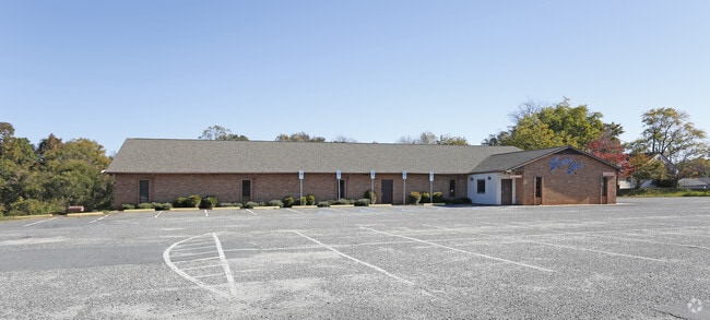
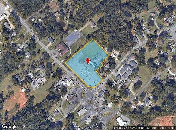
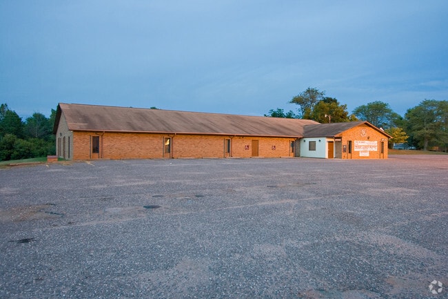
4571 S New Hope Rd
216483
15 066A 001 00 000
Restaurantbuilding
Gaston
X
North Carolina
3710358300J
3.11 AC
2025
Gaston County
2025
Charlotte
030302
Charlotte-Concord-Gastonia, NC-SC
8,772 SF
DEMOGRAPHICS near 4571 S New Hope Rd
1 Mile
3 Mile
5 Mile
2024 Total Population
2,305
27,703
77,259
2029 Population
2,509
30,003
83,297
Pop Growth 2024-2029
+ 8.85%
+ 8.30%
+ 7.82%
Average Age
41
40
40
2024 Total Households
846
10,842
30,994
HH Growth 2024-2029
+ 9.10%
+ 8.48%
+ 7.99%
Median Household Inc
$83,487
$87,931
$75,075
Avg Household Size
2.60
2.50
2.40
2024 Avg HH Vehicles
2.00
2.00
2.00
Median Home Value
$303,082
$283,195
$272,247
Median Year Built
2002
1997
1992
Nearby Places
Map Layers
Map Styles
 Street
 Aerial
- Restaurants
- Banks
- Shops
- Fitness
- Groceries
PUBLIC TRANSPORTATION
AIRPORT
Charlotte/Douglas International
DRIVE
WALK
Distance
Charlotte/Douglas International
26 min
16.1 mi
Freight Ports
Port of Wilmington
DRIVE
WALK
Distance
Port of Wilmington
1 min
190.7 mi
SALE & LEASE HISTORY
LISTING DATE
SALE/LEASE

Nov 02, 2017
For Sale
Dec 06, 2017
For Lease
Nearby Properties
Address
Land Use
TOTAL SIZE
Lot Size
Zoning
Address
Land Use
TOTAL SIZE
Lot Size
Zoning
25,137 SF
34.81 AC
Address
Land Use
TOTAL SIZE
Lot Size
Zoning
30,906 SF
14.19 AC
Address
Land Use
TOTAL SIZE
Lot Size
Zoning
98.12 AC
Address
Land Use
TOTAL SIZE
Lot Size
Zoning
78.54 AC
GR
Address
Land Use
TOTAL SIZE
Lot Size
Zoning
4,552 SF
9.22 AC
R1
Address
Land Use
TOTAL SIZE
Lot Size
Zoning
1,596 SF
5.73 AC
OFF01
Address
Land Use
TOTAL SIZE
Lot Size
Zoning
10,172 SF
33.34 AC
PUB01
Address
Land Use
TOTAL SIZE
Lot Size
Zoning
102,915 SF
39.29 AC
PUB01
Address
Land Use
TOTAL SIZE
Lot Size
Zoning
67,682 SF
8.86 AC
Address
Land Use
TOTAL SIZE
Lot Size
Zoning
2,836 SF
74.13 AC
OFF03
Address
Land Use
TOTAL SIZE
Lot Size
Zoning
1,280 SF
4.83 AC
APT01
Address
Land Use
TOTAL SIZE
Lot Size
Zoning
27,024 SF
4.94 AC
CHUR2
Address
Land Use
TOTAL SIZE
Lot Size
Zoning
12,810 SF
70.55 AC
INDS2
Address
Land Use
TOTAL SIZE
Lot Size
Zoning
26,456 SF
60.66 AC
SP01
Address
Land Use
TOTAL SIZE
Lot Size
Zoning
39,108 SF
5.02 AC
CHUR1
Address
Land Use
TOTAL SIZE
Lot Size
Zoning
12,000 SF
8.11 AC
R1
Address
Land Use
TOTAL SIZE
Lot Size
Zoning
450 SF
3.43 AC
APT01
Address
Land Use
TOTAL SIZE
Lot Size
Zoning
41,170 SF
3.93 AC
HCAR4
Address
Land Use
TOTAL SIZE
Lot Size
Zoning
21,698 SF
2.34 AC
Address
Land Use
TOTAL SIZE
Lot Size
Zoning
22,828 SF
5.58 AC
Address
Land Use
TOTAL SIZE
Lot Size
Zoning
64,316 SF
21.13 AC
PUB01
Address
Land Use
TOTAL SIZE
Lot Size
Zoning
40,125 SF
10.08 AC
STOR2
Address
Land Use
TOTAL SIZE
Lot Size
Zoning
30,240 SF
6.43 AC
CHUR2
Address
Land Use
TOTAL SIZE
Lot Size
Zoning
47,509 SF
2.23 AC
CHUR1
Address
Land Use
TOTAL SIZE
Lot Size
Zoning
11,150 SF
9.72 AC
CHUR1
Address
Land Use
TOTAL SIZE
Lot Size
Zoning
13,712 SF
0.46 AC
NCC
Address
Land Use
TOTAL SIZE
Lot Size
Zoning
51,900 SF
21.42 AC
PUB01
Address
Land Use
TOTAL SIZE
Lot Size
Zoning
8,480 SF
24.83 AC
STOR3
Address
Land Use
TOTAL SIZE
Lot Size
Zoning
46,784 SF
1.61 AC
PUB01
Address
Land Use
TOTAL SIZE
Lot Size
Zoning
2,222 SF
16.37 AC
R1
The World's #1 Commercial Real Estate Marketplace
Connect with us
© 2025 CoStar Group
The information above has been obtained from sources believed reliable. While we do not doubt its accuracy we have not verified it and make no guarantee, warranty or representation about it. It is your responsibility to independently confirm its accuracy and completeness. Any projections, opinions, assumptions, or estimates used are for example only and do not represent the current or future performance of the property. The value of this transaction to you depends on tax and other factors which should be evaluated by your tax, financial, and legal advisors. You and your advisors should conduct a careful, independent investigation of the property to determine to your satisfaction the suitability of the property for your needs.