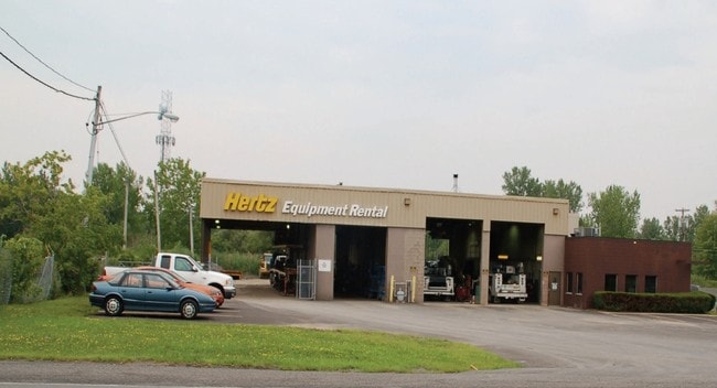
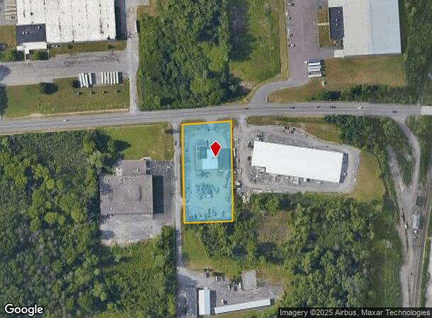
Property Record
4578 Buckley Rd, Liverpool, NY 13088
NEARBY LISTINGS FOR SALE OR LEASE
Property Detail
4578 Buckley Rd
312489-095-000-0002-007-000-0000
FL 76
Warehouse
Onondaga
X
New York
36067C0089F
7.000
2025
1.84 AC
2024
NE Outer Onondaga County
011102
Syracuse
7,124 SF
Syracuse, NY
DEMOGRAPHICS near 4578 Buckley Rd
1 Mile
3 Mile
5 Mile
2024 Total Population
5,907
52,515
105,630
2029 Population
5,762
51,013
102,796
Pop Growth 2024-2029
(2.45%)
(2.86%)
(2.68%)
Average Age
40
42
42
2024 Total Households
2,524
22,478
44,872
HH Growth 2024-2029
(2.58%)
(3.04%)
(2.86%)
Median Household Inc
$82,442
$74,358
$71,566
Avg Household Size
2.30
2.30
2.30
2024 Avg HH Vehicles
2.00
2.00
2.00
Median Home Value
$168,456
$169,128
$160,170
Median Year Built
1973
1972
1970
Nearby Places
- Restaurants
- Banks
- Shops
- Fitness
- Groceries
PUBLIC TRANSPORTATION
COMMUTER RAIL
DRIVE
WALK
Distance
12 min
6.2 mi
DRIVE
WALK
Distance
12 min
6.2 mi
AIRPORT
Syracuse Hancock International
DRIVE
WALK
Distance
Syracuse Hancock International
14 min
5.8 mi
Nearby Properties
Address
Land Use
TOTAL SIZE
Lot Size
Zoning
Address
Land Use
TOTAL SIZE
Lot Size
Zoning
7,392 SF
14.86 AC
03 - MULTI
Address
Land Use
TOTAL SIZE
Lot Size
Zoning
77,150 SF
159.25 AC
06 - INDUS
Address
Land Use
TOTAL SIZE
Lot Size
Zoning
151,326 SF
9.23 AC
05 - COMME
Address
Land Use
TOTAL SIZE
Lot Size
Zoning
3,968 SF
14.31 AC
03 - MULTI
Address
Land Use
TOTAL SIZE
Lot Size
Zoning
7,229 SF
111.29 AC
05 - COMME
Address
Land Use
TOTAL SIZE
Lot Size
Zoning
11,952 SF
9.14 AC
03 - MULTI
Address
Land Use
TOTAL SIZE
Lot Size
Zoning
3.59 AC
04 - FARM
Address
Land Use
TOTAL SIZE
Lot Size
Zoning
32,586 SF
6.87 AC
06 - INDUS
Address
Land Use
TOTAL SIZE
Lot Size
Zoning
57,993 SF
18.43 AC
02 - SINGL
Address
Land Use
TOTAL SIZE
Lot Size
Zoning
3,744 SF
10.60 AC
03 - MULTI
Address
Land Use
TOTAL SIZE
Lot Size
Zoning
3,696 SF
10.12 AC
03 - MULTI
Address
Land Use
TOTAL SIZE
Lot Size
Zoning
71,194 SF
10.76 AC
02 - SINGL
Address
Land Use
TOTAL SIZE
Lot Size
Zoning
11,059 SF
8.23 AC
06 - INDUS
Address
Land Use
TOTAL SIZE
Lot Size
Zoning
57,993 SF
16.80 AC
02 - SINGL
Address
Land Use
TOTAL SIZE
Lot Size
Zoning
14,508 SF
8.74 AC
03 - MULTI
Address
Land Use
TOTAL SIZE
Lot Size
Zoning
210,170 SF
17.87 AC
06 - INDUS
Address
Land Use
TOTAL SIZE
Lot Size
Zoning
8,992 SF
6.63 AC
06 - INDUS
Address
Land Use
TOTAL SIZE
Lot Size
Zoning
57,723 SF
4.77 AC
06 - INDUS
Address
Land Use
TOTAL SIZE
Lot Size
Zoning
11,059 SF
5.30 AC
06 - INDUS
Address
Land Use
TOTAL SIZE
Lot Size
Zoning
17,064 SF
4.04 AC
03 - MULTI
Address
Land Use
TOTAL SIZE
Lot Size
Zoning
82,071 SF
6.29 AC
06 - INDUS
Address
Land Use
TOTAL SIZE
Lot Size
Zoning
45,228 SF
26.84 AC
04 - FARM
Address
Land Use
TOTAL SIZE
Lot Size
Zoning
13,911 SF
2.48 AC
03 - MULTI
Address
Land Use
TOTAL SIZE
Lot Size
Zoning
291.81 AC
04 - FARM
Address
Land Use
TOTAL SIZE
Lot Size
Zoning
17,251 SF
32.17 AC
08 - GOVER
Address
Land Use
TOTAL SIZE
Lot Size
Zoning
10,983 SF
3.49 AC
06 - INDUS
Address
Land Use
TOTAL SIZE
Lot Size
Zoning
23,820 SF
0.49 AC
05 - COMME
Address
Land Use
TOTAL SIZE
Lot Size
Zoning
35,042 SF
4.39 AC
03 - MULTI
Address
Land Use
TOTAL SIZE
Lot Size
Zoning
40,328 SF
7.43 AC
05 - COMME
Address
Land Use
TOTAL SIZE
Lot Size
Zoning
16,589 SF
0.50 AC
05 - COMME
The World's #1 Commercial Real Estate Marketplace
Connect with us
© 2025 CoStar Group
The information above has been obtained from sources believed reliable. While we do not doubt its accuracy we have not verified it and make no guarantee, warranty or representation about it. It is your responsibility to independently confirm its accuracy and completeness. Any projections, opinions, assumptions, or estimates used are for example only and do not represent the current or future performance of the property. The value of this transaction to you depends on tax and other factors which should be evaluated by your tax, financial, and legal advisors. You and your advisors should conduct a careful, independent investigation of the property to determine to your satisfaction the suitability of the property for your needs.