Property Record
458 Senoia Rd, Tyrone, GA 30290
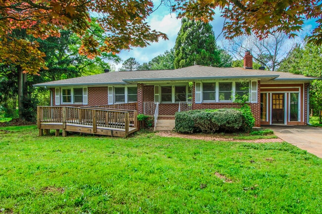
This Property Is For Sale
NEARBY LISTINGS FOR SALE OR LEASE
Property Detail
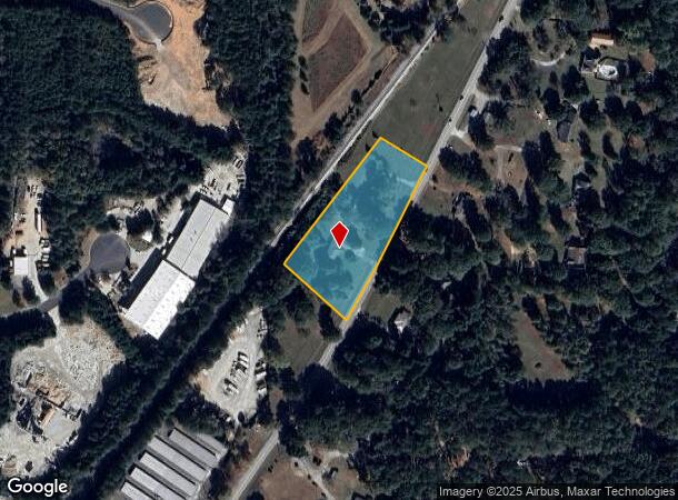
458 Senoia Rd
Atlanta-Sandy Springs-Roswell, GA
Senoia Road
07-36-00-021
Fayette
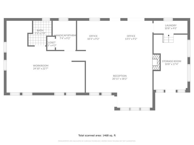
Duplex
Georgia
X
Fayette/Coweta County
13077C0180D
Atlanta
DEMOGRAPHICS near 458 Senoia Rd
1 Mile
3 Mile
5 Mile
2024 Total Population
2,449
26,975
59,503
2029 Population
2,585
28,716
63,871
Pop Growth 2024-2029
+ 5.55%
+ 6.45%
+ 7.34%
Average Age
42
43
42
2024 Total Households
905
9,877
21,359
HH Growth 2024-2029
+ 5.41%
+ 6.40%
+ 7.32%
Median Household Inc
$97,643
$105,627
$101,956
Avg Household Size
2.70
2.70
2.80
2024 Avg HH Vehicles
2.00
2.00
2.00
Median Home Value
$482,758
$409,438
$377,156
Median Year Built
1996
1995
1994
Nearby Places
- Restaurants
- Banks
- Shops
- Fitness
- Groceries
PUBLIC TRANSPORTATION
AIRPORT
Hartsfield - Jackson Atlanta International
DRIVE
WALK
Distance
Hartsfield - Jackson Atlanta International
33 min
21.7 mi
Freight Ports
Georgia Ports - Savannah
DRIVE
WALK
Distance
Georgia Ports - Savannah
289 min
246.2 mi
Nearby Properties
Address
Land Use
TOTAL SIZE
Lot Size
Zoning
Address
Land Use
TOTAL SIZE
Lot Size
Zoning
194,839 SF
25.40 AC
C GC
Address
Land Use
TOTAL SIZE
Lot Size
Zoning
118,729 SF
21.25 AC
C GR10
Address
Land Use
TOTAL SIZE
Lot Size
Zoning
218,763 SF
38.40 AC
C GC
Address
Land Use
TOTAL SIZE
Lot Size
Zoning
102,516 SF
19.60 AC
Address
Land Use
TOTAL SIZE
Lot Size
Zoning
75,217 SF
15 AC
CS
Address
Land Use
TOTAL SIZE
Lot Size
Zoning
39,195 SF
14.06 AC
C GC
Address
Land Use
TOTAL SIZE
Lot Size
Zoning
96,409 SF
12.74 AC
C GC
Address
Land Use
TOTAL SIZE
Lot Size
Zoning
55,360 SF
4.80 AC
C LUC
Address
Land Use
TOTAL SIZE
Lot Size
Zoning
230.80 AC
Address
Land Use
TOTAL SIZE
Lot Size
Zoning
93,925 SF
5.18 AC
C GC
Address
Land Use
TOTAL SIZE
Lot Size
Zoning
80,800 SF
9.39 AC
C C2
Address
Land Use
TOTAL SIZE
Lot Size
Zoning
35,802 SF
4.39 AC
C OI
Address
Land Use
TOTAL SIZE
Lot Size
Zoning
80,956 SF
60.90 AC
Address
Land Use
TOTAL SIZE
Lot Size
Zoning
52,001 SF
4.01 AC
C GC
Address
Land Use
TOTAL SIZE
Lot Size
Zoning
125,421 SF
12.99 AC
C GC
Address
Land Use
TOTAL SIZE
Lot Size
Zoning
47,555 SF
20.10 AC
AR
Address
Land Use
TOTAL SIZE
Lot Size
Zoning
43,812 SF
10 AC
C GR10
Address
Land Use
TOTAL SIZE
Lot Size
Zoning
14,636 SF
6.50 AC
C OI
Address
Land Use
TOTAL SIZE
Lot Size
Zoning
31,490 SF
2.48 AC
C GC
Address
Land Use
TOTAL SIZE
Lot Size
Zoning
75,847 SF
15.82 AC
R1
Address
Land Use
TOTAL SIZE
Lot Size
Zoning
35,455 SF
2.30 AC
C GC
Address
Land Use
TOTAL SIZE
Lot Size
Zoning
36,900 SF
8.12 AC
C OI
Address
Land Use
TOTAL SIZE
Lot Size
Zoning
49,935 SF
3.99 AC
C GC
Address
Land Use
TOTAL SIZE
Lot Size
Zoning
66,390 SF
3.61 AC
I M1
Address
Land Use
TOTAL SIZE
Lot Size
Zoning
59,421 SF
8.40 AC
C GR12
Address
Land Use
TOTAL SIZE
Lot Size
Zoning
4.80 AC
C LUC
Address
Land Use
TOTAL SIZE
Lot Size
Zoning
12,859 SF
50.50 AC
Address
Land Use
TOTAL SIZE
Lot Size
Zoning
38,477 SF
3.50 AC
C GC
Address
Land Use
TOTAL SIZE
Lot Size
Zoning
26,327 SF
2.84 AC
C LUC
Address
Land Use
TOTAL SIZE
Lot Size
Zoning
25,496 SF
264 AC
The World's #1 Commercial Real Estate Marketplace
Connect with us
© 2025 CoStar Group
The information above has been obtained from sources believed reliable. While we do not doubt its accuracy we have not verified it and make no guarantee, warranty or representation about it. It is your responsibility to independently confirm its accuracy and completeness. Any projections, opinions, assumptions, or estimates used are for example only and do not represent the current or future performance of the property. The value of this transaction to you depends on tax and other factors which should be evaluated by your tax, financial, and legal advisors. You and your advisors should conduct a careful, independent investigation of the property to determine to your satisfaction the suitability of the property for your needs.