Property Record
4597 Ne State Road 24, Bronson, FL 32621

Save to a Folder
{{folder.Name}}
{{folder.ListingIds.length}} Properties
{{folder.ListingIds.length}} Property
Create a New Folder
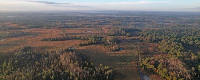
Property Detail
4597 Ne State Road 24
Gainesville, FL
10-12-16 0435.92 ACRES N1/2 & SE1/4 OR BOOK 1654 PAGE 675 -LESS S1/2 OF SW1/4 OF NW1/4 OF AND LESS SE1/4 OF N1/2 OF NW1/4 OF SW1/4 OF SE1/4 & LESS OR BOOK 763 PAGE 787-
02505-000-00
LEVY
Pasture
Florida
A Areas with a 1% annual chance of flooding and a 26% chance of flooding over the life of a 30-year mortgage.
359 AC
2024
Florida Central North Area
2025
Other Market Areas
970103
NEARBY LISTINGS FOR SALE OR LEASE
-
-
View all Bronson listings for sale on LoopNet.com
DEMOGRAPHICS near 4597 Ne State Road 24
1 mile
3 mile
5 mile
2025 Total Population
0
151
2,910
2030 Population
0
164
3,209
Pop Growth 2025-2030
0.00%
+ 8.61%
+ 10.27%
Average Age
0
42
41
2025 Total Households
0
56
1,106
HH Growth 2025-2030
0.00%
+ 8.93%
+ 10.31%
Median Household Inc
$0
$60,625
$58,928
Avg Household Size
.00
2.50
2.60
2025 Avg HH Vehicles
.00
2.00
2.00
Median Home Value
$0
$162,499
$158,914
Median Year Built
0
1989
1989
Nearby Places
Map Layers
Map Styles
 Street
 Aerial
Layers
 Traffic
 Biking
Places
Listings with unknown addresses are not visible on the map
- Restaurants
- Banks
- Shops
- Fitness
- Groceries
SALE & LEASE HISTORY
LISTING DATE
SALE/LEASE

Feb 03, 2022
For Sale
Nearby Properties
Address
Land Use
TOTAL SIZE
Lot Size
Zoning
Address
Land Use
TOTAL SIZE
Lot Size
Zoning
Address
Land Use
TOTAL SIZE
Lot Size
Zoning
Address
Land Use
TOTAL SIZE
Lot Size
Zoning
2,411 SF
559.45 AC
5500
Address
Land Use
TOTAL SIZE
Lot Size
Zoning
1,809 SF
195.94 AC
5500
Address
Land Use
TOTAL SIZE
Lot Size
Zoning
1,188 SF
55.83 AC
Address
Land Use
TOTAL SIZE
Lot Size
Zoning
148.70 AC
Address
Land Use
TOTAL SIZE
Lot Size
Zoning
228.43 AC
Address
Land Use
TOTAL SIZE
Lot Size
Zoning
223.06 AC
5500
Address
Land Use
TOTAL SIZE
Lot Size
Zoning
22.41 AC
The World's #1 Commercial Real Estate Marketplace
Connect with us
© 2026 CoStar Group
The information above has been obtained from sources believed reliable. While we do not doubt its accuracy we have not verified it and make no guarantee, warranty or representation about it. It is your responsibility to independently confirm its accuracy and completeness. Any projections, opinions, assumptions, or estimates used are for example only and do not represent the current or future performance of the property. The value of this transaction to you depends on tax and other factors which should be evaluated by your tax, financial, and legal advisors. You and your advisors should conduct a careful, independent investigation of the property to determine to your satisfaction the suitability of the property for your needs.