Property Record
45990 Waterview Plz, Sterling, VA 20166
NEARBY LISTINGS FOR SALE OR LEASE
Property Detail
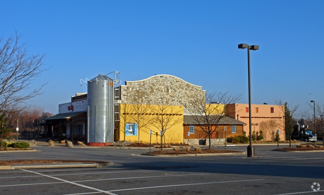
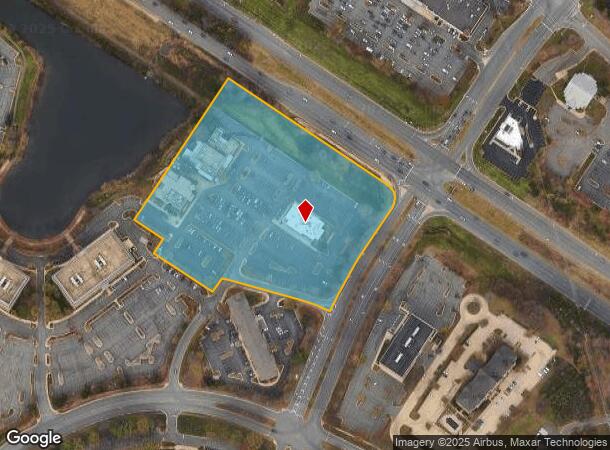
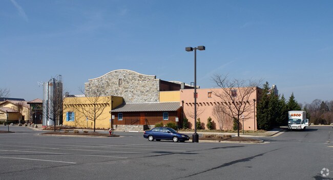
45990 Waterview Plz
Washington-Arlington-Alexandria, DC-VA-MD-WV
Loudoun Tech Center
029-20-7651
LOUDOUN TECH CENTER PARCEL A1A 1449--233 1633--1862 BLA PC E-199-2
Restaurantbuilding
Loudoun
X
Virginia
51107C0266E
a
2025
7.41 AC
2025
Route 28 Corridor North
611501
Washington, DC
26,197 SF
DEMOGRAPHICS near 45990 Waterview Plz
1 Mile
3 Mile
5 Mile
2024 Total Population
12,090
92,599
191,708
2029 Population
12,965
99,387
202,315
Pop Growth 2024-2029
+ 7.24%
+ 7.33%
+ 5.53%
Average Age
37
39
39
2024 Total Households
4,380
31,897
66,680
HH Growth 2024-2029
+ 7.40%
+ 7.67%
+ 5.88%
Median Household Inc
$117,853
$127,004
$136,282
Avg Household Size
2.70
2.80
2.80
2024 Avg HH Vehicles
2.00
2.00
2.00
Median Home Value
$651,493
$547,722
$620,338
Median Year Built
1994
1991
1992
Nearby Places
Map Layers
Map Styles
 Street
 Aerial
- Restaurants
- Banks
- Shops
- Fitness
- Groceries
PUBLIC TRANSPORTATION
AIRPORT
Washington Dulles International
DRIVE
WALK
Distance
Washington Dulles International
19 min
8.6 mi
Ronald Reagan Washington Ntl
DRIVE
WALK
Distance
Ronald Reagan Washington Ntl
45 min
28.5 mi
Freight Ports
Port of Baltimore
DRIVE
WALK
Distance
Port of Baltimore
85 min
60.4 mi
Nearby Properties
Address
Land Use
TOTAL SIZE
Lot Size
Zoning
Address
Land Use
TOTAL SIZE
Lot Size
Zoning
650,346 SF
PDMUB
Address
Land Use
TOTAL SIZE
Lot Size
Zoning
234,124 SF
23.84 AC
PDOP
Address
Land Use
TOTAL SIZE
Lot Size
Zoning
672,272 SF
44.53 AC
PDIP
Address
Land Use
TOTAL SIZE
Lot Size
Zoning
2,735,138 SF
123.03 AC
PDAAAR
Address
Land Use
TOTAL SIZE
Lot Size
Zoning
364,600 SF
PDOP
Address
Land Use
TOTAL SIZE
Lot Size
Zoning
565,680 SF
18.44 AC
PDIP
Address
Land Use
TOTAL SIZE
Lot Size
Zoning
228,606 SF
PDOP
Address
Land Use
TOTAL SIZE
Lot Size
Zoning
455,793 SF
22.60 AC
IP
Address
Land Use
TOTAL SIZE
Lot Size
Zoning
180,355 SF
12.89 AC
PDIP
Address
Land Use
TOTAL SIZE
Lot Size
Zoning
154,125 SF
9.68 AC
PDIP
Address
Land Use
TOTAL SIZE
Lot Size
Zoning
364,650 SF
PDOP
Address
Land Use
TOTAL SIZE
Lot Size
Zoning
169,092 SF
PDMUB
Address
Land Use
TOTAL SIZE
Lot Size
Zoning
109,320 SF
7.20 AC
PDIP
Address
Land Use
TOTAL SIZE
Lot Size
Zoning
253,352 SF
PDOP
Address
Land Use
TOTAL SIZE
Lot Size
Zoning
685,682 SF
53.96 AC
PDIP
Address
Land Use
TOTAL SIZE
Lot Size
Zoning
123,200 SF
4.74 AC
PDIP
Address
Land Use
TOTAL SIZE
Lot Size
Zoning
405,058 SF
19.88 AC
IP
Address
Land Use
TOTAL SIZE
Lot Size
Zoning
481,791 SF
41.28 AC
PDIP
Address
Land Use
TOTAL SIZE
Lot Size
Zoning
180,039 SF
15.98 AC
PDOP
Address
Land Use
TOTAL SIZE
Lot Size
Zoning
259,194 SF
10.18 AC
PDIP
Address
Land Use
TOTAL SIZE
Lot Size
Zoning
148,717 SF
PDIP
Address
Land Use
TOTAL SIZE
Lot Size
Zoning
219,514 SF
14.34 AC
PDIP
Address
Land Use
TOTAL SIZE
Lot Size
Zoning
87,560 SF
PDIP
Address
Land Use
TOTAL SIZE
Lot Size
Zoning
446,732 SF
37.94 AC
PDIP
Address
Land Use
TOTAL SIZE
Lot Size
Zoning
119,087 SF
339.95 AC
PDIP
Address
Land Use
TOTAL SIZE
Lot Size
Zoning
429,711 SF
34.74 AC
PDH4
Address
Land Use
TOTAL SIZE
Lot Size
Zoning
426,710 SF
19.50 AC
PDIP
Address
Land Use
TOTAL SIZE
Lot Size
Zoning
430,507 SF
25.60 AC
R16
Address
Land Use
TOTAL SIZE
Lot Size
Zoning
100,121 SF
2.20 AC
PDIP
Address
Land Use
TOTAL SIZE
Lot Size
Zoning
396,198 SF
5.84 AC
PDMUB
The World's #1 Commercial Real Estate Marketplace
Connect with us
© 2026 CoStar Group
The information above has been obtained from sources believed reliable. While we do not doubt its accuracy we have not verified it and make no guarantee, warranty or representation about it. It is your responsibility to independently confirm its accuracy and completeness. Any projections, opinions, assumptions, or estimates used are for example only and do not represent the current or future performance of the property. The value of this transaction to you depends on tax and other factors which should be evaluated by your tax, financial, and legal advisors. You and your advisors should conduct a careful, independent investigation of the property to determine to your satisfaction the suitability of the property for your needs.