Property Record
5330 Se Adams St, Topeka, KS 66609

This Property Is For Sale
NEARBY LISTINGS FOR SALE OR LEASE
Property Detail
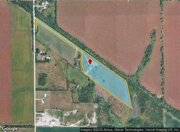
5330 Se Adams St
Topeka, KS
Shawnee
139-32-0-00-02-002-030
Kansas
Sfr
12.33 AC
X
Topeka
20177C0310E
Kansas City
3,808 SF
DEMOGRAPHICS near 5330 Se Adams St
1 Mile
3 Mile
5 Mile
2024 Total Population
125
18,896
62,632
2029 Population
126
18,800
62,107
Pop Growth 2024-2029
+ 0.80%
(0.51%)
(0.84%)
Average Age
44
38
39
2024 Total Households
57
7,190
25,235
HH Growth 2024-2029
0.00%
(0.43%)
(0.91%)
Median Household Inc
$54,375
$53,304
$51,147
Avg Household Size
2.30
2.50
2.40
2024 Avg HH Vehicles
2.00
2.00
2.00
Median Home Value
$92,307
$114,082
$130,569
Median Year Built
1986
1973
1971
Nearby Places
Map Layers
Map Styles
 Street
 Aerial
- Restaurants
- Banks
- Shops
- Fitness
- Groceries
PUBLIC TRANSPORTATION
COMMUTER RAIL
Topeka Amtrak Station (Southwest Chief - Amtrak)
DRIVE
WALK
Distance
Topeka Amtrak Station (Southwest Chief - Amtrak)
15 min
6.5 mi
Freight Ports
Tulsa Port Of Catoosa
DRIVE
WALK
Distance
Tulsa Port Of Catoosa
272 min
220.5 mi
Nearby Properties
Address
Land Use
TOTAL SIZE
Lot Size
Zoning
Address
Land Use
TOTAL SIZE
Lot Size
Zoning
797,582 SF
384.32 AC
I1,I2
Address
Land Use
TOTAL SIZE
Lot Size
Zoning
577,341 SF
152.58 AC
I2
Address
Land Use
TOTAL SIZE
Lot Size
Zoning
103,285 SF
16.99 AC
I1,PUD
Address
Land Use
TOTAL SIZE
Lot Size
Zoning
1,351,980 SF
141.63 AC
I1
Address
Land Use
TOTAL SIZE
Lot Size
Zoning
602,448 SF
43.68 AC
I1
Address
Land Use
TOTAL SIZE
Lot Size
Zoning
165,001 SF
24.83 AC
R1
Address
Land Use
TOTAL SIZE
Lot Size
Zoning
1,250 SF
630.34 AC
RR1
Address
Land Use
TOTAL SIZE
Lot Size
Zoning
156,628 SF
44.05 AC
I1
Address
Land Use
TOTAL SIZE
Lot Size
Zoning
465,600 SF
52.91 AC
I1
Address
Land Use
TOTAL SIZE
Lot Size
Zoning
40,321 SF
5.69 AC
I1
Address
Land Use
TOTAL SIZE
Lot Size
Zoning
53,815 SF
15.40 AC
RR1
Address
Land Use
TOTAL SIZE
Lot Size
Zoning
188,358 SF
183.64 AC
I1,RR1
Address
Land Use
TOTAL SIZE
Lot Size
Zoning
56,485 SF
11.58 AC
I1
Address
Land Use
TOTAL SIZE
Lot Size
Zoning
65,918 SF
20.81 AC
RR1
Address
Land Use
TOTAL SIZE
Lot Size
Zoning
4.81 AC
Address
Land Use
TOTAL SIZE
Lot Size
Zoning
3,525 SF
1.89 AC
C3
Address
Land Use
TOTAL SIZE
Lot Size
Zoning
64,248 SF
13.78 AC
RR1
Address
Land Use
TOTAL SIZE
Lot Size
Zoning
207,235 SF
22.74 AC
C3
Address
Land Use
TOTAL SIZE
Lot Size
Zoning
1,253,081 SF
73.17 AC
I1
Address
Land Use
TOTAL SIZE
Lot Size
Zoning
100,822 SF
8.50 AC
C4
Address
Land Use
TOTAL SIZE
Lot Size
Zoning
417.49 AC
RR1
Address
Land Use
TOTAL SIZE
Lot Size
Zoning
134,915 SF
20 AC
I1
Address
Land Use
TOTAL SIZE
Lot Size
Zoning
36,512 SF
6.72 AC
R2
Address
Land Use
TOTAL SIZE
Lot Size
Zoning
18.56 AC
I1
Address
Land Use
TOTAL SIZE
Lot Size
Zoning
26,939 SF
6.25 AC
R1
Address
Land Use
TOTAL SIZE
Lot Size
Zoning
35,856 SF
4.76 AC
I1
Address
Land Use
TOTAL SIZE
Lot Size
Zoning
144.10 AC
PUD,I1,RR1
Address
Land Use
TOTAL SIZE
Lot Size
Zoning
56,849 SF
29.75 AC
Address
Land Use
TOTAL SIZE
Lot Size
Zoning
11,820 SF
2.75 AC
RR1
Address
Land Use
TOTAL SIZE
Lot Size
Zoning
132,055 SF
41.77 AC
I1
The World's #1 Commercial Real Estate Marketplace
Connect with us
© 2025 CoStar Group
The information above has been obtained from sources believed reliable. While we do not doubt its accuracy we have not verified it and make no guarantee, warranty or representation about it. It is your responsibility to independently confirm its accuracy and completeness. Any projections, opinions, assumptions, or estimates used are for example only and do not represent the current or future performance of the property. The value of this transaction to you depends on tax and other factors which should be evaluated by your tax, financial, and legal advisors. You and your advisors should conduct a careful, independent investigation of the property to determine to your satisfaction the suitability of the property for your needs.