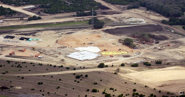
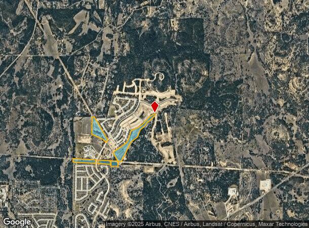
Property Record
46 E State Highway 46 St, Boerne, TX 78006
NEARBY LISTINGS FOR SALE OR LEASE
Property Detail
46 E State Highway 46 St
15028
Survey 190 J Ortiz
Agriculturalland
A10363 - SURVEY 190 J ORTIZ 58.266 ACRES
AE
Kendall
48259C0425F
Texas
2024
58.27 AC
2025
Kendall County
970404
San Antonio
7,669 SF
San Antonio-New Braunfels, TX
DEMOGRAPHICS near 46 E State Highway 46 St
1 Mile
3 Mile
5 Mile
2024 Total Population
2,667
19,333
35,089
2029 Population
3,372
24,249
44,038
Pop Growth 2024-2029
+ 26.43%
+ 25.43%
+ 25.50%
Average Age
39
41
41
2024 Total Households
893
7,069
12,903
HH Growth 2024-2029
+ 26.88%
+ 25.82%
+ 25.91%
Median Household Inc
$116,213
$94,118
$98,321
Avg Household Size
2.90
2.70
2.70
2024 Avg HH Vehicles
2.00
2.00
2.00
Median Home Value
$375,108
$391,169
$418,798
Median Year Built
2010
2002
2004
Nearby Places
Map Layers
Map Styles
 Street
 Aerial
- Restaurants
- Banks
- Shops
- Fitness
- Groceries
PUBLIC TRANSPORTATION
AIRPORT
San Antonio International
DRIVE
WALK
Distance
San Antonio International
51 min
32.5 mi
Freight Ports
Calhoun Port
DRIVE
WALK
Distance
Calhoun Port
230 min
184.1 mi
Nearby Properties
Address
Land Use
TOTAL SIZE
Lot Size
Zoning
Address
Land Use
TOTAL SIZE
Lot Size
Zoning
315,748 SF
102.19 AC
Address
Land Use
TOTAL SIZE
Lot Size
Zoning
236,676 SF
55.67 AC
Address
Land Use
TOTAL SIZE
Lot Size
Zoning
78,586 SF
15.36 AC
Address
Land Use
TOTAL SIZE
Lot Size
Zoning
111,517 SF
20.86 AC
Address
Land Use
TOTAL SIZE
Lot Size
Zoning
215,475 SF
13.14 AC
Address
Land Use
TOTAL SIZE
Lot Size
Zoning
94,142 SF
40.34 AC
Address
Land Use
TOTAL SIZE
Lot Size
Zoning
166,650 SF
14.62 AC
Address
Land Use
TOTAL SIZE
Lot Size
Zoning
8,515 SF
59.67 AC
Address
Land Use
TOTAL SIZE
Lot Size
Zoning
49,307 SF
1.07 AC
Address
Land Use
TOTAL SIZE
Lot Size
Zoning
48,975 SF
2.98 AC
Address
Land Use
TOTAL SIZE
Lot Size
Zoning
20,834 SF
161.08 AC
Address
Land Use
TOTAL SIZE
Lot Size
Zoning
113,692 SF
6.52 AC
Address
Land Use
TOTAL SIZE
Lot Size
Zoning
26,100 SF
1.17 AC
Address
Land Use
TOTAL SIZE
Lot Size
Zoning
103,625 SF
4.88 AC
Address
Land Use
TOTAL SIZE
Lot Size
Zoning
28,282 SF
11.78 AC
Address
Land Use
TOTAL SIZE
Lot Size
Zoning
26,920 SF
4.32 AC
Address
Land Use
TOTAL SIZE
Lot Size
Zoning
48,972 SF
4.80 AC
Address
Land Use
TOTAL SIZE
Lot Size
Zoning
10,800 SF
13.12 AC
Address
Land Use
TOTAL SIZE
Lot Size
Zoning
68,889 SF
2.17 AC
Address
Land Use
TOTAL SIZE
Lot Size
Zoning
15,508 SF
1.62 AC
Address
Land Use
TOTAL SIZE
Lot Size
Zoning
38,323 SF
3 AC
Address
Land Use
TOTAL SIZE
Lot Size
Zoning
17,579 SF
0.96 AC
Address
Land Use
TOTAL SIZE
Lot Size
Zoning
11,520 SF
41.46 AC
Address
Land Use
TOTAL SIZE
Lot Size
Zoning
22,716 SF
2.98 AC
Address
Land Use
TOTAL SIZE
Lot Size
Zoning
80.43 AC
Address
Land Use
TOTAL SIZE
Lot Size
Zoning
27,937 SF
5.79 AC
Address
Land Use
TOTAL SIZE
Lot Size
Zoning
16,702 SF
1.96 AC
Address
Land Use
TOTAL SIZE
Lot Size
Zoning
16,067 SF
4.35 AC
Address
Land Use
TOTAL SIZE
Lot Size
Zoning
16,022 SF
3.80 AC
Address
Land Use
TOTAL SIZE
Lot Size
Zoning
72,325 SF
6.43 AC
The World's #1 Commercial Real Estate Marketplace
Connect with us
© 2026 CoStar Group
The information above has been obtained from sources believed reliable. While we do not doubt its accuracy we have not verified it and make no guarantee, warranty or representation about it. It is your responsibility to independently confirm its accuracy and completeness. Any projections, opinions, assumptions, or estimates used are for example only and do not represent the current or future performance of the property. The value of this transaction to you depends on tax and other factors which should be evaluated by your tax, financial, and legal advisors. You and your advisors should conduct a careful, independent investigation of the property to determine to your satisfaction the suitability of the property for your needs.