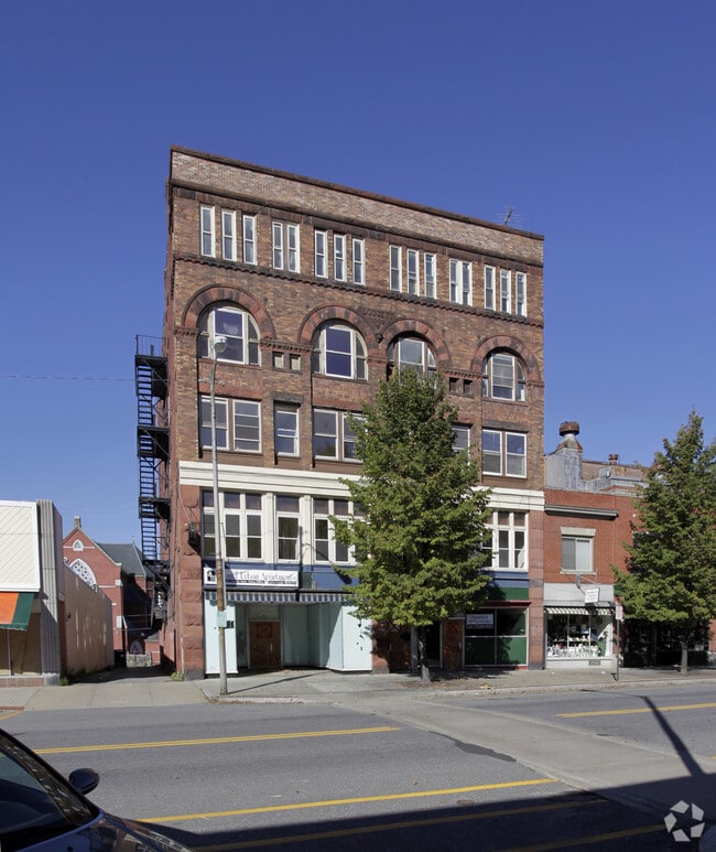
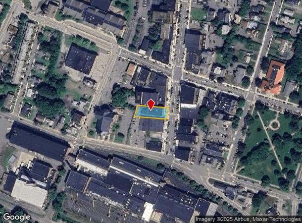
Property Record
46 High St, Clinton, MA 01510


NEARBY LISTINGS FOR SALE OR LEASE
-
-
View all Clinton listings for sale on LoopNet.com
Property Detail
46 High St
Commercialofficeresidentialmixeduse
Worcester
X
Massachusetts
25027C0466G
0.29 AC
0
Northeast Worcester County
2025
Boston
716300
Worcester, MA
22,952 SF
CLIN-000001-001511
DEMOGRAPHICS near 46 High St
1 Mile
3 Mile
5 Mile
2024 Total Population
11,655
22,612
36,547
2029 Population
11,606
22,528
36,462
Pop Growth 2024-2029
(0.42%)
(0.37%)
(0.23%)
Average Age
40
41
42
2024 Total Households
4,968
9,253
14,245
HH Growth 2024-2029
(0.48%)
(0.42%)
(0.27%)
Median Household Inc
$80,617
$90,666
$100,372
Avg Household Size
2.30
2.40
2.50
2024 Avg HH Vehicles
2.00
2.00
2.00
Median Home Value
$332,843
$386,320
$430,579
Median Year Built
1948
1958
1968
Nearby Places
Map Layers
Map Styles
 Street
 Aerial
- Restaurants
- Banks
- Shops
- Fitness
- Groceries
PUBLIC TRANSPORTATION
AIRPORT
Worcester Regional
DRIVE
WALK
Distance
Worcester Regional
34 min
18.0 mi
General Edward Lawrence Logan International
DRIVE
WALK
Distance
General Edward Lawrence Logan International
65 min
48.2 mi
Freight Ports
Port of Boston
DRIVE
WALK
Distance
Port of Boston
64 min
46.5 mi
SALE & LEASE HISTORY
LISTING DATE
SALE/LEASE

Nov 08, 2016
For Sale
Nearby Properties
Address
Land Use
TOTAL SIZE
Lot Size
Zoning
Address
Land Use
TOTAL SIZE
Lot Size
Zoning
26.80 AC
Address
Land Use
TOTAL SIZE
Lot Size
Zoning
344,000 SF
20.63 AC
Address
Land Use
TOTAL SIZE
Lot Size
Zoning
168,653 SF
6.50 AC
Address
Land Use
TOTAL SIZE
Lot Size
Zoning
455,636 SF
54.47 AC
Address
Land Use
TOTAL SIZE
Lot Size
Zoning
85,557 SF
9.27 AC
Address
Land Use
TOTAL SIZE
Lot Size
Zoning
64,497 SF
3.27 AC
Address
Land Use
TOTAL SIZE
Lot Size
Zoning
8.46 AC
Address
Land Use
TOTAL SIZE
Lot Size
Zoning
128,324 SF
1.03 AC
Address
Land Use
TOTAL SIZE
Lot Size
Zoning
174,412 SF
Address
Land Use
TOTAL SIZE
Lot Size
Zoning
12.69 AC
Address
Land Use
TOTAL SIZE
Lot Size
Zoning
2.37 AC
Address
Land Use
TOTAL SIZE
Lot Size
Zoning
147,092 SF
36.90 AC
Address
Land Use
TOTAL SIZE
Lot Size
Zoning
16,504 SF
0.45 AC
Address
Land Use
TOTAL SIZE
Lot Size
Zoning
5,050 SF
11.92 AC
Address
Land Use
TOTAL SIZE
Lot Size
Zoning
2.07 AC
Address
Land Use
TOTAL SIZE
Lot Size
Zoning
4,536 SF
48.38 AC
Address
Land Use
TOTAL SIZE
Lot Size
Zoning
158,900 SF
80 AC
Address
Land Use
TOTAL SIZE
Lot Size
Zoning
48,240 SF
0.59 AC
Address
Land Use
TOTAL SIZE
Lot Size
Zoning
133,068 SF
9 AC
Address
Land Use
TOTAL SIZE
Lot Size
Zoning
1.61 AC
Address
Land Use
TOTAL SIZE
Lot Size
Zoning
884 SF
59.40 AC
R1
Address
Land Use
TOTAL SIZE
Lot Size
Zoning
33,050 SF
7.80 AC
Address
Land Use
TOTAL SIZE
Lot Size
Zoning
70,516 SF
23 AC
Address
Land Use
TOTAL SIZE
Lot Size
Zoning
12.66 AC
Address
Land Use
TOTAL SIZE
Lot Size
Zoning
0.01 AC
Address
Land Use
TOTAL SIZE
Lot Size
Zoning
7,344 SF
Address
Land Use
TOTAL SIZE
Lot Size
Zoning
26,939 SF
0.75 AC
Address
Land Use
TOTAL SIZE
Lot Size
Zoning
1.81 AC
Address
Land Use
TOTAL SIZE
Lot Size
Zoning
24,776 SF
13.58 AC
Address
Land Use
TOTAL SIZE
Lot Size
Zoning
36,878 SF
1.60 AC
The World's #1 Commercial Real Estate Marketplace
Connect with us
© 2026 CoStar Group
The information above has been obtained from sources believed reliable. While we do not doubt its accuracy we have not verified it and make no guarantee, warranty or representation about it. It is your responsibility to independently confirm its accuracy and completeness. Any projections, opinions, assumptions, or estimates used are for example only and do not represent the current or future performance of the property. The value of this transaction to you depends on tax and other factors which should be evaluated by your tax, financial, and legal advisors. You and your advisors should conduct a careful, independent investigation of the property to determine to your satisfaction the suitability of the property for your needs.