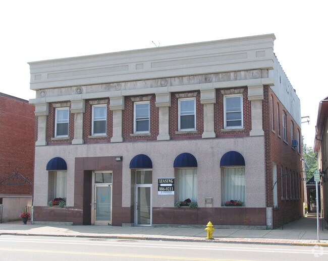
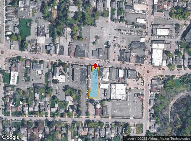
Property Record
46 Main St, Hamburg, NY 14075
NEARBY LISTINGS FOR SALE OR LEASE
Property Detail
46 Main St
144803-196-090-0006-010-100
Erie
Officebuilding
New York
X
10.100
36029C0479H
0.34 AC
2025
South
2024
Buffalo/Niagara Falls
013400
Buffalo-Cheektowaga, NY
5,593 SF
DEMOGRAPHICS near 46 Main St
1 Mile
3 Mile
5 Mile
2024 Total Population
8,599
29,804
68,370
2029 Population
8,638
29,976
68,636
Pop Growth 2024-2029
+ 0.45%
+ 0.58%
+ 0.39%
Average Age
42
43
44
2024 Total Households
3,632
12,371
28,841
HH Growth 2024-2029
+ 0.30%
+ 0.46%
+ 0.32%
Median Household Inc
$93,138
$82,812
$77,423
Avg Household Size
2.30
2.30
2.30
2024 Avg HH Vehicles
2.00
2.00
2.00
Median Home Value
$239,204
$247,618
$236,696
Median Year Built
1949
1971
1975
Nearby Places
Map Layers
Map Styles
 Street
 Aerial
- Restaurants
- Banks
- Shops
- Fitness
- Groceries
PUBLIC TRANSPORTATION
AIRPORT
Buffalo Niagara International
DRIVE
WALK
Distance
Buffalo Niagara International
34 min
21.7 mi
Niagara Falls International
DRIVE
WALK
Distance
Niagara Falls International
52 min
33.3 mi
SALE & LEASE HISTORY
LISTING DATE
SALE/LEASE

Aug 04, 2020
For Lease
Nearby Properties
Address
Land Use
TOTAL SIZE
Lot Size
Zoning
Address
Land Use
TOTAL SIZE
Lot Size
Zoning
14,835 SF
215.22 AC
C2
Address
Land Use
TOTAL SIZE
Lot Size
Zoning
77,270 SF
46.15 AC
C3
Address
Land Use
TOTAL SIZE
Lot Size
Zoning
118,358 SF
59.67 AC
Address
Land Use
TOTAL SIZE
Lot Size
Zoning
218,461 SF
27.59 AC
C2
Address
Land Use
TOTAL SIZE
Lot Size
Zoning
157,973 SF
16.50 AC
Address
Land Use
TOTAL SIZE
Lot Size
Zoning
10,486 SF
25.30 AC
R3
Address
Land Use
TOTAL SIZE
Lot Size
Zoning
49.70 AC
02 - SINGL
Address
Land Use
TOTAL SIZE
Lot Size
Zoning
221,896 SF
21.50 AC
Address
Land Use
TOTAL SIZE
Lot Size
Zoning
137,276 SF
5.10 AC
Address
Land Use
TOTAL SIZE
Lot Size
Zoning
7,680 SF
14.20 AC
R3
Address
Land Use
TOTAL SIZE
Lot Size
Zoning
7,448 SF
12.16 AC
Address
Land Use
TOTAL SIZE
Lot Size
Zoning
74,669 SF
9.23 AC
Address
Land Use
TOTAL SIZE
Lot Size
Zoning
33,296 SF
12.50 AC
C1
Address
Land Use
TOTAL SIZE
Lot Size
Zoning
136,770 SF
15.20 AC
Address
Land Use
TOTAL SIZE
Lot Size
Zoning
2,252 SF
7.01 AC
R3
Address
Land Use
TOTAL SIZE
Lot Size
Zoning
139,145 SF
33.24 AC
C1
Address
Land Use
TOTAL SIZE
Lot Size
Zoning
24.50 AC
Address
Land Use
TOTAL SIZE
Lot Size
Zoning
4,664 SF
18.10 AC
R3
Address
Land Use
TOTAL SIZE
Lot Size
Zoning
Address
Land Use
TOTAL SIZE
Lot Size
Zoning
Address
Land Use
TOTAL SIZE
Lot Size
Zoning
14,978 SF
3.80 AC
C2
Address
Land Use
TOTAL SIZE
Lot Size
Zoning
4.60 AC
Address
Land Use
TOTAL SIZE
Lot Size
Zoning
84,500 SF
8.20 AC
R3
Address
Land Use
TOTAL SIZE
Lot Size
Zoning
57,339 SF
2.90 AC
Address
Land Use
TOTAL SIZE
Lot Size
Zoning
71,434 SF
15.90 AC
Address
Land Use
TOTAL SIZE
Lot Size
Zoning
Address
Land Use
TOTAL SIZE
Lot Size
Zoning
29,088 SF
5 AC
C2
Address
Land Use
TOTAL SIZE
Lot Size
Zoning
102,369 SF
9.80 AC
C1
Address
Land Use
TOTAL SIZE
Lot Size
Zoning
Address
Land Use
TOTAL SIZE
Lot Size
Zoning
The World's #1 Commercial Real Estate Marketplace
Connect with us
© 2026 CoStar Group
The information above has been obtained from sources believed reliable. While we do not doubt its accuracy we have not verified it and make no guarantee, warranty or representation about it. It is your responsibility to independently confirm its accuracy and completeness. Any projections, opinions, assumptions, or estimates used are for example only and do not represent the current or future performance of the property. The value of this transaction to you depends on tax and other factors which should be evaluated by your tax, financial, and legal advisors. You and your advisors should conduct a careful, independent investigation of the property to determine to your satisfaction the suitability of the property for your needs.