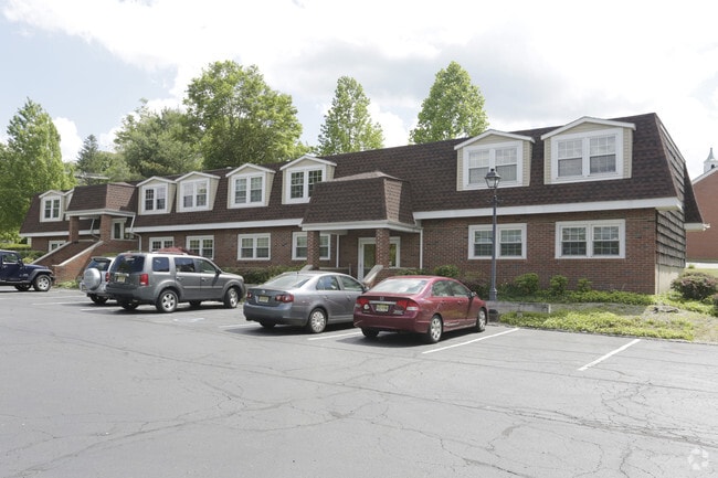
Property Record
46 Main St, Sparta, NJ 07871


NEARBY LISTINGS FOR SALE OR LEASE
Property Detail
46 Main St
18-05019-0000-00005
Sussex
Officebuilding
New Jersey
X
5
34037C0317E
0.79 AC
2024
Sussex County
2025
Northern New Jersey
373100
Newark, NJ
7,200 SF
DEMOGRAPHICS near 46 Main St
1 Mile
3 Mile
5 Mile
2024 Total Population
2,827
17,244
33,688
2029 Population
2,846
17,479
34,101
Pop Growth 2024-2029
+ 0.67%
+ 1.36%
+ 1.23%
Average Age
44
42
42
2024 Total Households
1,141
6,237
12,227
HH Growth 2024-2029
+ 0.44%
+ 1.36%
+ 1.23%
Median Household Inc
$99,739
$136,219
$130,851
Avg Household Size
2.40
2.70
2.70
2024 Avg HH Vehicles
2.00
2.00
2.00
Median Home Value
$371,428
$408,037
$391,583
Median Year Built
1974
1973
1972
Nearby Places
Map Layers
Map Styles
 Street
 Aerial
- Restaurants
- Banks
- Shops
- Fitness
- Groceries
PUBLIC TRANSPORTATION
AIRPORT
Newark Liberty International
DRIVE
WALK
Distance
Newark Liberty International
58 min
42.4 mi
Freight Ports
Maher Terminal
DRIVE
WALK
Distance
Maher Terminal
63 min
43.0 mi
SALE & LEASE HISTORY
LISTING DATE
SALE/LEASE

Sep 25, 2016
For Lease
Sep 24, 2016
For Sale
May 14, 2018
For Lease
Mar 05, 2019
For Lease
Jun 15, 2018
For Lease
Nearby Properties
Address
Land Use
TOTAL SIZE
Lot Size
Zoning
Address
Land Use
TOTAL SIZE
Lot Size
Zoning
134,375 SF
27.71 AC
OSGU
Address
Land Use
TOTAL SIZE
Lot Size
Zoning
132,501 SF
91.14 AC
OSGU
Address
Land Use
TOTAL SIZE
Lot Size
Zoning
11.86 AC
TCLC
Address
Land Use
TOTAL SIZE
Lot Size
Zoning
28.91 AC
PVC
Address
Land Use
TOTAL SIZE
Lot Size
Zoning
10 AC
RR
Address
Land Use
TOTAL SIZE
Lot Size
Zoning
2.02 AC
PVC
Address
Land Use
TOTAL SIZE
Lot Size
Zoning
50,659 SF
9.90 AC
C-2
Address
Land Use
TOTAL SIZE
Lot Size
Zoning
2.27 AC
PVC
Address
Land Use
TOTAL SIZE
Lot Size
Zoning
58,607 SF
26.13 AC
RR
Address
Land Use
TOTAL SIZE
Lot Size
Zoning
3,280 SF
17.30 AC
MF
Address
Land Use
TOTAL SIZE
Lot Size
Zoning
11,843 SF
9.68 AC
RR
Address
Land Use
TOTAL SIZE
Lot Size
Zoning
34,715 SF
3 AC
TCC
Address
Land Use
TOTAL SIZE
Lot Size
Zoning
47,786 SF
8.60 AC
TCCO
Address
Land Use
TOTAL SIZE
Lot Size
Zoning
35,884 SF
4.73 AC
C-2
Address
Land Use
TOTAL SIZE
Lot Size
Zoning
48,238 SF
25 AC
OSGU
Address
Land Use
TOTAL SIZE
Lot Size
Zoning
528 SF
10.85 AC
RR
Address
Land Use
TOTAL SIZE
Lot Size
Zoning
5,954 SF
5.07 AC
TCC
Address
Land Use
TOTAL SIZE
Lot Size
Zoning
15,400 SF
53.92 AC
PDRM
Address
Land Use
TOTAL SIZE
Lot Size
Zoning
14,967 SF
82.85 AC
RR
Address
Land Use
TOTAL SIZE
Lot Size
Zoning
17,324 SF
1.50 AC
TCC
Address
Land Use
TOTAL SIZE
Lot Size
Zoning
31,504 SF
3.06 AC
ED-1
Address
Land Use
TOTAL SIZE
Lot Size
Zoning
23,184 SF
82.13 AC
OSGU
Address
Land Use
TOTAL SIZE
Lot Size
Zoning
37,638 SF
2.20 AC
TCMS
Address
Land Use
TOTAL SIZE
Lot Size
Zoning
10 AC
RR
Address
Land Use
TOTAL SIZE
Lot Size
Zoning
35,301 SF
3.74 AC
TCC
Address
Land Use
TOTAL SIZE
Lot Size
Zoning
5.59 AC
TCLC
Address
Land Use
TOTAL SIZE
Lot Size
Zoning
42,036 SF
2.94 AC
C-1
Address
Land Use
TOTAL SIZE
Lot Size
Zoning
22,528 SF
7.50 AC
RR
Address
Land Use
TOTAL SIZE
Lot Size
Zoning
45,445 SF
8.65 AC
ED
Address
Land Use
TOTAL SIZE
Lot Size
Zoning
28,317 SF
1.36 AC
C-2
The World's #1 Commercial Real Estate Marketplace
Connect with us
© 2026 CoStar Group
The information above has been obtained from sources believed reliable. While we do not doubt its accuracy we have not verified it and make no guarantee, warranty or representation about it. It is your responsibility to independently confirm its accuracy and completeness. Any projections, opinions, assumptions, or estimates used are for example only and do not represent the current or future performance of the property. The value of this transaction to you depends on tax and other factors which should be evaluated by your tax, financial, and legal advisors. You and your advisors should conduct a careful, independent investigation of the property to determine to your satisfaction the suitability of the property for your needs.