Property Record
46 Noblestown Rd Ext, Carnegie, PA 15106

Property Detail
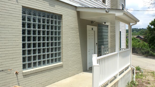
46 Noblestown Rd Ext
Pittsburgh, PA
JAS EWINGS PL1-2 LOT 75XAVG61.02 X84.05 INALL FIRST ST COR MAIN ST 2 STY BRK-STN COTE & ALUM SDG BLDG (UNF)
0147-K-00006-0000-00
ALLEGHENY
Storebuilding
Pennsylvania
B and X Area of moderate flood hazard, usually the area between the limits of the 100-year and 500-year floods.
6
2024
0.11 AC
2025
Parkway West Corridor
468800
Pittsburgh
NEARBY LISTINGS FOR SALE OR LEASE
DEMOGRAPHICS near 46 Noblestown Rd Ext
1 mile
3 mile
5 mile
2025 Total Population
4,594
52,746
172,032
2030 Population
4,483
51,798
168,901
Pop Growth 2025-2030
(2.42%)
(1.80%)
(1.82%)
Average Age
45
44
43
2025 Total Households
2,199
23,595
75,259
HH Growth 2025-2030
(2.41%)
(1.90%)
(1.89%)
Median Household Inc
$84,260
$90,060
$90,961
Avg Household Size
2.00
2.10
2.20
2025 Avg HH Vehicles
2.00
2.00
2.00
Median Home Value
$241,522
$253,858
$262,416
Median Year Built
1965
1961
1957
Nearby Places
Map Layers
Map Styles
 Street
 Aerial
Transit
 Traffic
 Biking
Places
Listings with unknown addresses are not visible on the map
- Restaurants
- Banks
- Shops
- Fitness
- Groceries
PUBLIC TRANSPORTATION
COMMUTER RAIL
Drive
Walk
Distance
16 min
8.4 mi
AIRPORT
Pittsburgh International
Drive
Walk
Distance
Pittsburgh International
22 min
13.2 mi
SALE & LEASE HISTORY
LISTING DATE
SALE/LEASE

Aug 28, 2017
For Lease
Nearby Properties
Address
Land Use
TOTAL SIZE
Lot Size
Zoning
Address
Land Use
TOTAL SIZE
Lot Size
Zoning
Address
Land Use
TOTAL SIZE
Lot Size
Zoning
62.76 AC
Address
Land Use
TOTAL SIZE
Lot Size
Zoning
15.88 AC
Address
Land Use
TOTAL SIZE
Lot Size
Zoning
14.32 AC
Address
Land Use
TOTAL SIZE
Lot Size
Zoning
21.38 AC
Address
Land Use
TOTAL SIZE
Lot Size
Zoning
Address
Land Use
TOTAL SIZE
Lot Size
Zoning
12.68 AC
Address
Land Use
TOTAL SIZE
Lot Size
Zoning
17.50 AC
Address
Land Use
TOTAL SIZE
Lot Size
Zoning
16.01 AC
Address
Land Use
TOTAL SIZE
Lot Size
Zoning
10.07 AC
Address
Land Use
TOTAL SIZE
Lot Size
Zoning
36.95 AC
Address
Land Use
TOTAL SIZE
Lot Size
Zoning
17.04 AC
Address
Land Use
TOTAL SIZE
Lot Size
Zoning
Address
Land Use
TOTAL SIZE
Lot Size
Zoning
15.26 AC
Address
Land Use
TOTAL SIZE
Lot Size
Zoning
16.70 AC
Address
Land Use
TOTAL SIZE
Lot Size
Zoning
1,272 SF
40.99 AC
Address
Land Use
TOTAL SIZE
Lot Size
Zoning
29.27 AC
Address
Land Use
TOTAL SIZE
Lot Size
Zoning
Address
Land Use
TOTAL SIZE
Lot Size
Zoning
20.31 AC
Address
Land Use
TOTAL SIZE
Lot Size
Zoning
19.18 AC
Address
Land Use
TOTAL SIZE
Lot Size
Zoning
71.84 AC
Address
Land Use
TOTAL SIZE
Lot Size
Zoning
Address
Land Use
TOTAL SIZE
Lot Size
Zoning
12.34 AC
Address
Land Use
TOTAL SIZE
Lot Size
Zoning
Address
Land Use
TOTAL SIZE
Lot Size
Zoning
13.32 AC
Address
Land Use
TOTAL SIZE
Lot Size
Zoning
Address
Land Use
TOTAL SIZE
Lot Size
Zoning
14.95 AC
Address
Land Use
TOTAL SIZE
Lot Size
Zoning
Address
Land Use
TOTAL SIZE
Lot Size
Zoning
Address
Land Use
TOTAL SIZE
Lot Size
Zoning
1.80 AC
The World's #1 Commercial Real Estate Marketplace
Connect with us
© 2026 CoStar Group
The information above has been obtained from sources believed reliable. While we do not doubt its accuracy we have not verified it and make no guarantee, warranty or representation about it. It is your responsibility to independently confirm its accuracy and completeness. Any projections, opinions, assumptions, or estimates used are for example only and do not represent the current or future performance of the property. The value of this transaction to you depends on tax and other factors which should be evaluated by your tax, financial, and legal advisors. You and your advisors should conduct a careful, independent investigation of the property to determine to your satisfaction the suitability of the property for your needs.