Property Record
46 Park Pl, Branford, CT 06405
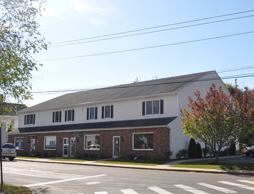


Property Detail
46 Park Pl
BRAN-000007D-000005-000009
South Central Ct
Commercialbuilding
Connecticut
C and X Area of minimal flood hazard, usually depicted on FIRMs as above the 500-year flood level.
9
2025
0.78 AC
2025
Branford
184101
Westchester/So Connecticut
9,450 SF
New Haven, CT
NEARBY LISTINGS FOR SALE OR LEASE
DEMOGRAPHICS near 46 Park Pl
1 mile
3 mile
5 mile
2025 Total Population
7,914
35,601
104,910
2030 Population
8,042
36,446
106,136
Pop Growth 2025-2030
+ 1.62%
+ 2.37%
+ 1.17%
Average Age
46
47
43
2025 Total Households
3,930
16,063
44,277
HH Growth 2025-2030
+ 1.53%
+ 2.35%
+ 1.45%
Median Household Inc
$73,404
$89,802
$74,597
Avg Household Size
2.00
2.20
2.30
2025 Avg HH Vehicles
2.00
2.00
2.00
Median Home Value
$360,693
$383,135
$331,317
Median Year Built
1972
1972
1968
Nearby Places
Map Layers
Map Styles
 Street
 Aerial
Transit
 Traffic
 Biking
Places
Listings with unknown addresses are not visible on the map
- Restaurants
- Banks
- Shops
- Fitness
- Groceries
PUBLIC TRANSPORTATION
COMMUTER RAIL
Branford (Shore Line East - Shore Line East)
Drive
Walk
Distance
Branford (Shore Line East - Shore Line East)
4 min
15 min
0.8 mi
New Haven-State Street Station (New Haven Line - Metro-North Commuter Railroad Company (Metro-North))
Drive
Walk
Distance
New Haven-State Street Station (New Haven Line - Metro-North Commuter Railroad Company (Metro-North))
14 min
7.3 mi
SALE & LEASE HISTORY
LISTING DATE
SALE/LEASE

Sep 24, 2016
For Lease
Nov 30, 2018
For Lease
Mar 27, 2017
For Lease
Apr 06, 2017
For Sale
Nearby Properties
Address
Land Use
TOTAL SIZE
Lot Size
Zoning
Address
Land Use
TOTAL SIZE
Lot Size
Zoning
227,335 SF
38.50 AC
Address
Land Use
TOTAL SIZE
Lot Size
Zoning
175,913 SF
29 AC
Address
Land Use
TOTAL SIZE
Lot Size
Zoning
7,065 SF
9.44 AC
Address
Land Use
TOTAL SIZE
Lot Size
Zoning
7.72 AC
RA-1
Address
Land Use
TOTAL SIZE
Lot Size
Zoning
16.50 AC
Address
Land Use
TOTAL SIZE
Lot Size
Zoning
5.50 AC
Address
Land Use
TOTAL SIZE
Lot Size
Zoning
35 AC
RA-1
Address
Land Use
TOTAL SIZE
Lot Size
Zoning
44,676 SF
7 AC
Address
Land Use
TOTAL SIZE
Lot Size
Zoning
48,726 SF
9.46 AC
Address
Land Use
TOTAL SIZE
Lot Size
Zoning
19.26 AC
R-2
Address
Land Use
TOTAL SIZE
Lot Size
Zoning
9.34 AC
CA-1
Address
Land Use
TOTAL SIZE
Lot Size
Zoning
10,892 SF
5.05 AC
Address
Land Use
TOTAL SIZE
Lot Size
Zoning
19.50 AC
Address
Land Use
TOTAL SIZE
Lot Size
Zoning
34,341 SF
5.65 AC
Address
Land Use
TOTAL SIZE
Lot Size
Zoning
14,508 SF
14 AC
Address
Land Use
TOTAL SIZE
Lot Size
Zoning
5,089 SF
25.20 AC
R18
Address
Land Use
TOTAL SIZE
Lot Size
Zoning
4.87 AC
Address
Land Use
TOTAL SIZE
Lot Size
Zoning
124,472 SF
16.60 AC
Address
Land Use
TOTAL SIZE
Lot Size
Zoning
94,311 SF
6.80 AC
Address
Land Use
TOTAL SIZE
Lot Size
Zoning
6,480 SF
15.94 AC
Address
Land Use
TOTAL SIZE
Lot Size
Zoning
14,030 SF
13.20 AC
Address
Land Use
TOTAL SIZE
Lot Size
Zoning
3,588 SF
15.80 AC
Address
Land Use
TOTAL SIZE
Lot Size
Zoning
10.20 AC
Address
Land Use
TOTAL SIZE
Lot Size
Zoning
40,682 SF
7.27 AC
Address
Land Use
TOTAL SIZE
Lot Size
Zoning
7.84 AC
Address
Land Use
TOTAL SIZE
Lot Size
Zoning
2.40 AC
Address
Land Use
TOTAL SIZE
Lot Size
Zoning
Address
Land Use
TOTAL SIZE
Lot Size
Zoning
13.90 AC
Address
Land Use
TOTAL SIZE
Lot Size
Zoning
54,799 SF
4.06 AC
Address
Land Use
TOTAL SIZE
Lot Size
Zoning
7.69 AC
RU1
The World's #1 Commercial Real Estate Marketplace
Connect with us
© 2026 CoStar Group
The information above has been obtained from sources believed reliable. While we do not doubt its accuracy we have not verified it and make no guarantee, warranty or representation about it. It is your responsibility to independently confirm its accuracy and completeness. Any projections, opinions, assumptions, or estimates used are for example only and do not represent the current or future performance of the property. The value of this transaction to you depends on tax and other factors which should be evaluated by your tax, financial, and legal advisors. You and your advisors should conduct a careful, independent investigation of the property to determine to your satisfaction the suitability of the property for your needs.