Property Record
46 Parsippany Blvd, Boonton, NJ 07005

NEARBY LISTINGS FOR SALE OR LEASE
-
-
-
No Photo
-
View all Boonton listings for sale on LoopNet.com
Property Detail
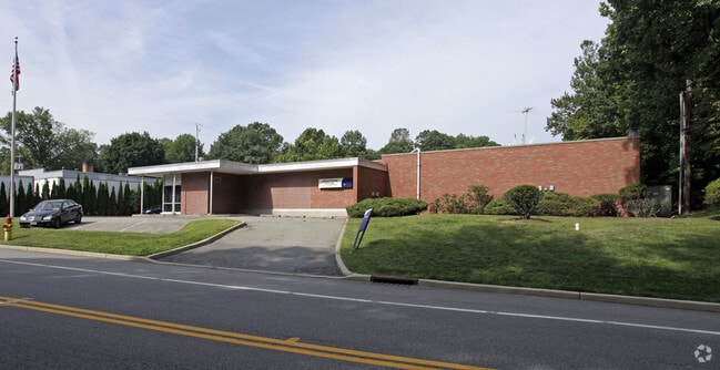
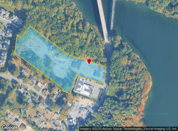
46 Parsippany Blvd
Newark, NJ-PA
ADDITIONAL LOTS: 32 4-B
29-00450-0000-00003
Morris
Utilities
New Jersey
2024
3
2025
6.19 AC
041801
Parsippany
17,488 SF
Northern New Jersey
DEMOGRAPHICS near 46 Parsippany Blvd
1 Mile
3 Mile
5 Mile
2024 Total Population
5,339
61,596
117,592
2029 Population
5,331
61,694
117,798
Pop Growth 2024-2029
(0.15%)
+ 0.16%
+ 0.18%
Average Age
42
42
42
2024 Total Households
2,014
23,263
44,171
HH Growth 2024-2029
(0.10%)
+ 0.24%
+ 0.22%
Median Household Inc
$96,042
$108,605
$120,044
Avg Household Size
2.60
2.60
2.60
2024 Avg HH Vehicles
2.00
2.00
2.00
Median Home Value
$527,778
$541,582
$548,275
Median Year Built
1957
1967
1968
Nearby Places
Map Layers
Map Styles
 Street
 Aerial
- Restaurants
- Banks
- Shops
- Fitness
- Groceries
PUBLIC TRANSPORTATION
COMMUTER RAIL
Boonton (Montclair-Boonton Line - NJ Transit Commuter Rail (NJ Transit))
DRIVE
WALK
Distance
Boonton (Montclair-Boonton Line - NJ Transit Commuter Rail (NJ Transit))
1 min
15 min
0.8 mi
Mountain Lakes (Montclair-Boonton Line - NJ Transit Commuter Rail (NJ Transit))
DRIVE
WALK
Distance
Mountain Lakes (Montclair-Boonton Line - NJ Transit Commuter Rail (NJ Transit))
5 min
1.9 mi
AIRPORT
Newark Liberty International
DRIVE
WALK
Distance
Newark Liberty International
35 min
27.1 mi
LaGuardia
DRIVE
WALK
Distance
LaGuardia
55 min
41.6 mi
Freight Ports
Maher Terminal
DRIVE
WALK
Distance
Maher Terminal
37 min
27.6 mi
Nearby Properties
Address
Land Use
TOTAL SIZE
Lot Size
Zoning
Address
Land Use
TOTAL SIZE
Lot Size
Zoning
98,228 SF
16.66 AC
I-1
Address
Land Use
TOTAL SIZE
Lot Size
Zoning
428,141 SF
12.30 AC
OB-3
Address
Land Use
TOTAL SIZE
Lot Size
Zoning
577,851 SF
35.90 AC
SD5A
Address
Land Use
TOTAL SIZE
Lot Size
Zoning
11,353 SF
9.29 AC
COD
Address
Land Use
TOTAL SIZE
Lot Size
Zoning
114,267 SF
27.26 AC
SED5
Address
Land Use
TOTAL SIZE
Lot Size
Zoning
257,220 SF
30.83 AC
SED5
Address
Land Use
TOTAL SIZE
Lot Size
Zoning
4.94 AC
OLV
Address
Land Use
TOTAL SIZE
Lot Size
Zoning
3.86 AC
O-3
Address
Land Use
TOTAL SIZE
Lot Size
Zoning
32.61 AC
R-5
Address
Land Use
TOTAL SIZE
Lot Size
Zoning
Address
Land Use
TOTAL SIZE
Lot Size
Zoning
201,648 SF
19.35 AC
B-1
Address
Land Use
TOTAL SIZE
Lot Size
Zoning
16.01 AC
R-C
Address
Land Use
TOTAL SIZE
Lot Size
Zoning
197,023 SF
22.08 AC
AHMU
Address
Land Use
TOTAL SIZE
Lot Size
Zoning
91,872 SF
31.16 AC
B-1
Address
Land Use
TOTAL SIZE
Lot Size
Zoning
1,440 SF
38.80 AC
I-2
Address
Land Use
TOTAL SIZE
Lot Size
Zoning
310,954 SF
22.99 AC
SED5
Address
Land Use
TOTAL SIZE
Lot Size
Zoning
140,560 SF
49.81 AC
R27A
Address
Land Use
TOTAL SIZE
Lot Size
Zoning
217,502 SF
25 AC
SED5
Address
Land Use
TOTAL SIZE
Lot Size
Zoning
Address
Land Use
TOTAL SIZE
Lot Size
Zoning
26.65 AC
AHD7
Address
Land Use
TOTAL SIZE
Lot Size
Zoning
323,904 SF
12 AC
SED5
Address
Land Use
TOTAL SIZE
Lot Size
Zoning
100,392 SF
19.18 AC
B-1
Address
Land Use
TOTAL SIZE
Lot Size
Zoning
4,172 SF
338 AC
R-1
Address
Land Use
TOTAL SIZE
Lot Size
Zoning
132,411 SF
24.87 AC
B-5
Address
Land Use
TOTAL SIZE
Lot Size
Zoning
17.33 AC
R-5
Address
Land Use
TOTAL SIZE
Lot Size
Zoning
10.80 AC
R-5
Address
Land Use
TOTAL SIZE
Lot Size
Zoning
5.87 AC
OL-2
Address
Land Use
TOTAL SIZE
Lot Size
Zoning
18.39 AC
R-5
Address
Land Use
TOTAL SIZE
Lot Size
Zoning
4.99 AC
OB
Address
Land Use
TOTAL SIZE
Lot Size
Zoning
180,898 SF
21.96 AC
SED5
The World's #1 Commercial Real Estate Marketplace
Connect with us
© 2025 CoStar Group
The information above has been obtained from sources believed reliable. While we do not doubt its accuracy we have not verified it and make no guarantee, warranty or representation about it. It is your responsibility to independently confirm its accuracy and completeness. Any projections, opinions, assumptions, or estimates used are for example only and do not represent the current or future performance of the property. The value of this transaction to you depends on tax and other factors which should be evaluated by your tax, financial, and legal advisors. You and your advisors should conduct a careful, independent investigation of the property to determine to your satisfaction the suitability of the property for your needs.