Property Record
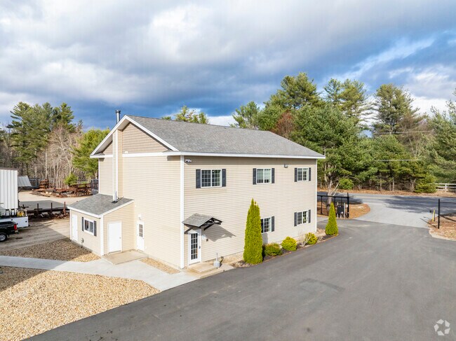
46 Route 13, Brookline, NH 03033


NEARBY LISTINGS FOR SALE OR LEASE
-
-
View all Brookline listings for sale on LoopNet.com
Property Detail
46 Route 13
BRKL-000001J-000000-000019
Hillsborough
Commercialnec
New Hampshire
A
19
25017C0060F
5.30 AC
2025
Hillsborough
2025
Boston
018001
Manchester-Nashua, NH
DEMOGRAPHICS near 46 Route 13
1 mile
3 mile
5 mile
2024 Total Population
1,144
6,219
19,316
2029 Population
1,163
6,271
19,277
Pop Growth 2024-2029
+ 1.66%
+ 0.84%
(0.20%)
Average Age
39
40
42
2024 Total Households
371
2,086
6,950
HH Growth 2024-2029
+ 1.62%
+ 0.77%
(0.37%)
Median Household Inc
$158,456
$149,600
$128,613
Avg Household Size
3.10
3.00
2.80
2024 Avg HH Vehicles
3.00
3.00
2.00
Median Home Value
$421,428
$437,616
$425,849
Median Year Built
1989
1984
1980
Nearby Places
Map Layers
Map Styles
 Street
 Aerial
Transit
 Traffic
 Biking
Places
Listings with unknown addresses are not visible on the map
- Restaurants
- Banks
- Shops
- Fitness
- Groceries
PUBLIC TRANSPORTATION
AIRPORT
Manchester Boston Regional
Drive
Walk
Distance
Manchester Boston Regional
44 min
24.4 mi
Worcester Regional
Drive
Walk
Distance
Worcester Regional
64 min
40.9 mi
Nearby Properties
Address
Land Use
TOTAL SIZE
Lot Size
Zoning
Address
Land Use
TOTAL SIZE
Lot Size
Zoning
17,858 SF
485 AC
RESIDE
Address
Land Use
TOTAL SIZE
Lot Size
Zoning
52,626 SF
110.16 AC
RESIDE
Address
Land Use
TOTAL SIZE
Lot Size
Zoning
50,873 SF
12.67 AC
RESIDE
Address
Land Use
TOTAL SIZE
Lot Size
Zoning
1,350 SF
9.33 AC
IN
Address
Land Use
TOTAL SIZE
Lot Size
Zoning
13.52 AC
COMM/I
Address
Land Use
TOTAL SIZE
Lot Size
Zoning
61,850 SF
13.57 AC
COMM/I
Address
Land Use
TOTAL SIZE
Lot Size
Zoning
36,711 SF
2.10 AC
COMM/I
Address
Land Use
TOTAL SIZE
Lot Size
Zoning
11,887 SF
3.85 AC
COMM/I
Address
Land Use
TOTAL SIZE
Lot Size
Zoning
3.65 AC
RESIDE
Address
Land Use
TOTAL SIZE
Lot Size
Zoning
17,728 SF
4.20 AC
COMM/I
Address
Land Use
TOTAL SIZE
Lot Size
Zoning
3,600 SF
2.21 AC
COMM/I
Address
Land Use
TOTAL SIZE
Lot Size
Zoning
2.30 AC
COMM/I
Address
Land Use
TOTAL SIZE
Lot Size
Zoning
6,502 SF
9.19 AC
RA
Address
Land Use
TOTAL SIZE
Lot Size
Zoning
14,700 SF
3.10 AC
IN
Address
Land Use
TOTAL SIZE
Lot Size
Zoning
5,017 SF
4.10 AC
RA
Address
Land Use
TOTAL SIZE
Lot Size
Zoning
4,740 SF
4.55 AC
RA
Address
Land Use
TOTAL SIZE
Lot Size
Zoning
7.70 AC
RESIDE
Address
Land Use
TOTAL SIZE
Lot Size
Zoning
2,947 SF
0.50 AC
RESIDE
Address
Land Use
TOTAL SIZE
Lot Size
Zoning
4,628 SF
4.54 AC
RA
Address
Land Use
TOTAL SIZE
Lot Size
Zoning
1.43 AC
COMM/I
Address
Land Use
TOTAL SIZE
Lot Size
Zoning
2,984 SF
2 AC
COMM/I
Address
Land Use
TOTAL SIZE
Lot Size
Zoning
4,447 SF
4 AC
RA
Address
Land Use
TOTAL SIZE
Lot Size
Zoning
30 AC
RESIDE
Address
Land Use
TOTAL SIZE
Lot Size
Zoning
5,008 SF
2.03 AC
RL
Address
Land Use
TOTAL SIZE
Lot Size
Zoning
5,574 SF
14.57 AC
RESIDE
Address
Land Use
TOTAL SIZE
Lot Size
Zoning
7,046 SF
1.24 AC
RESIDE
Address
Land Use
TOTAL SIZE
Lot Size
Zoning
110.62 AC
RESIDE
Address
Land Use
TOTAL SIZE
Lot Size
Zoning
4,336 SF
5.06 AC
RA
Address
Land Use
TOTAL SIZE
Lot Size
Zoning
3,887 SF
4.78 AC
RA
The World's #1 Commercial Real Estate Marketplace
Connect with us
© 2026 CoStar Group
The information above has been obtained from sources believed reliable. While we do not doubt its accuracy we have not verified it and make no guarantee, warranty or representation about it. It is your responsibility to independently confirm its accuracy and completeness. Any projections, opinions, assumptions, or estimates used are for example only and do not represent the current or future performance of the property. The value of this transaction to you depends on tax and other factors which should be evaluated by your tax, financial, and legal advisors. You and your advisors should conduct a careful, independent investigation of the property to determine to your satisfaction the suitability of the property for your needs.