Property Record
460 Branchview Dr Ne, Concord, NC 28025
NEARBY LISTINGS FOR SALE OR LEASE
Property Detail
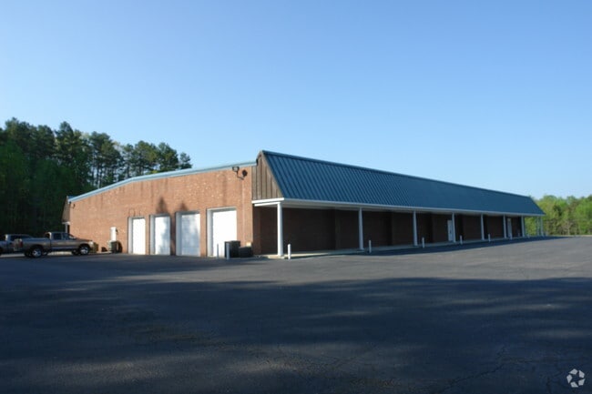
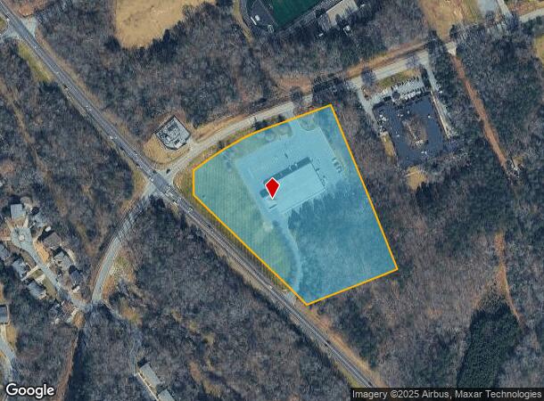
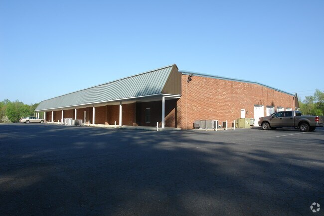
460 Branchview Dr Ne
5621-84-7828-0000
Branchview Commercial
Funeralhome
INT BRANCHVIEW & BROOKWOOD
X
Cabarrus
3710562100K
North Carolina
2025
8.74 AC
2025
Cabarrus County
042300
Charlotte
23,080 SF
Charlotte-Concord-Gastonia, NC-SC
DEMOGRAPHICS near 460 Branchview Dr Ne
1 Mile
3 Mile
5 Mile
2024 Total Population
5,889
42,934
102,935
2029 Population
6,614
48,540
116,389
Pop Growth 2024-2029
+ 12.31%
+ 13.06%
+ 13.07%
Average Age
40
39
39
2024 Total Households
2,426
16,733
39,107
HH Growth 2024-2029
+ 10.88%
+ 11.61%
+ 11.65%
Median Household Inc
$52,634
$51,431
$64,866
Avg Household Size
2.30
2.40
2.50
2024 Avg HH Vehicles
2.00
2.00
2.00
Median Home Value
$217,012
$199,569
$225,915
Median Year Built
1967
1976
1987
Nearby Places
Map Layers
Map Styles
 Street
 Aerial
- Restaurants
- Banks
- Shops
- Fitness
- Groceries
PUBLIC TRANSPORTATION
COMMUTER RAIL
Kannapolis Station (Piedmont - North Carolina by Train (NC Train))
DRIVE
WALK
Distance
Kannapolis Station (Piedmont - North Carolina by Train (NC Train))
11 min
6.6 mi
AIRPORT
Concord-Padgett Regional
DRIVE
WALK
Distance
Concord-Padgett Regional
22 min
12.4 mi
Charlotte/Douglas International
DRIVE
WALK
Distance
Charlotte/Douglas International
47 min
32.7 mi
Freight Ports
Port of Wilmington
DRIVE
WALK
Distance
Port of Wilmington
253 min
196.6 mi
Nearby Properties
Address
Land Use
TOTAL SIZE
Lot Size
Zoning
Address
Land Use
TOTAL SIZE
Lot Size
Zoning
280,149 SF
54.88 AC
C-2
Address
Land Use
TOTAL SIZE
Lot Size
Zoning
162,854 SF
2.11 AC
CC
Address
Land Use
TOTAL SIZE
Lot Size
Zoning
103,849 SF
3.03 AC
CC
Address
Land Use
TOTAL SIZE
Lot Size
Zoning
16,216 SF
24.13 AC
RC
Address
Land Use
TOTAL SIZE
Lot Size
Zoning
42,409 SF
16 AC
GC
Address
Land Use
TOTAL SIZE
Lot Size
Zoning
32,872 SF
0.90 AC
CC
Address
Land Use
TOTAL SIZE
Lot Size
Zoning
6,880 SF
18.34 AC
RC
Address
Land Use
TOTAL SIZE
Lot Size
Zoning
122,102 SF
4.69 AC
CC
Address
Land Use
TOTAL SIZE
Lot Size
Zoning
204,636 SF
109.77 AC
RM-1
Address
Land Use
TOTAL SIZE
Lot Size
Zoning
173,459 SF
15.03 AC
O-I
Address
Land Use
TOTAL SIZE
Lot Size
Zoning
161,202 SF
2.68 AC
CC
Address
Land Use
TOTAL SIZE
Lot Size
Zoning
15,215 SF
30.18 AC
RM-2
Address
Land Use
TOTAL SIZE
Lot Size
Zoning
15,156 SF
12.54 AC
RC
Address
Land Use
TOTAL SIZE
Lot Size
Zoning
90,350 SF
10.20 AC
PID
Address
Land Use
TOTAL SIZE
Lot Size
Zoning
44,136 SF
15.42 AC
R18
Address
Land Use
TOTAL SIZE
Lot Size
Zoning
15,924 SF
16.90 AC
RC
Address
Land Use
TOTAL SIZE
Lot Size
Zoning
12,480 SF
10.22 AC
RC
Address
Land Use
TOTAL SIZE
Lot Size
Zoning
24,618 SF
21.33 AC
R18
Address
Land Use
TOTAL SIZE
Lot Size
Zoning
29,957 SF
18.10 AC
PID
Address
Land Use
TOTAL SIZE
Lot Size
Zoning
29,259 SF
8.48 AC
RC
Address
Land Use
TOTAL SIZE
Lot Size
Zoning
122,182 SF
16.70 AC
C-2
Address
Land Use
TOTAL SIZE
Lot Size
Zoning
94,924 SF
0.39 AC
CC
Address
Land Use
TOTAL SIZE
Lot Size
Zoning
284,429 SF
48.08 AC
PUD
Address
Land Use
TOTAL SIZE
Lot Size
Zoning
12,696 SF
9.71 AC
RC
Address
Land Use
TOTAL SIZE
Lot Size
Zoning
13,824 SF
9.78 AC
RC
Address
Land Use
TOTAL SIZE
Lot Size
Zoning
117,919 SF
61.62 AC
RM-1
Address
Land Use
TOTAL SIZE
Lot Size
Zoning
18,288 SF
9.45 AC
RC
Address
Land Use
TOTAL SIZE
Lot Size
Zoning
76,336 SF
0.55 AC
CC
Address
Land Use
TOTAL SIZE
Lot Size
Zoning
88,934 SF
8 AC
PID
Address
Land Use
TOTAL SIZE
Lot Size
Zoning
30,170 SF
0.80 AC
CC
The World's #1 Commercial Real Estate Marketplace
Connect with us
© 2025 CoStar Group
The information above has been obtained from sources believed reliable. While we do not doubt its accuracy we have not verified it and make no guarantee, warranty or representation about it. It is your responsibility to independently confirm its accuracy and completeness. Any projections, opinions, assumptions, or estimates used are for example only and do not represent the current or future performance of the property. The value of this transaction to you depends on tax and other factors which should be evaluated by your tax, financial, and legal advisors. You and your advisors should conduct a careful, independent investigation of the property to determine to your satisfaction the suitability of the property for your needs.