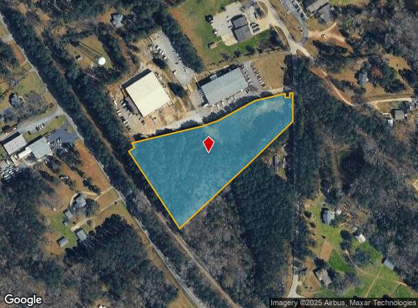
Property Record
460 E Boundary St, Chapin, SC 29036

NEARBY LISTINGS FOR SALE OR LEASE
Property Detail
460 E Boundary St
000700-03-195
PARCEL B
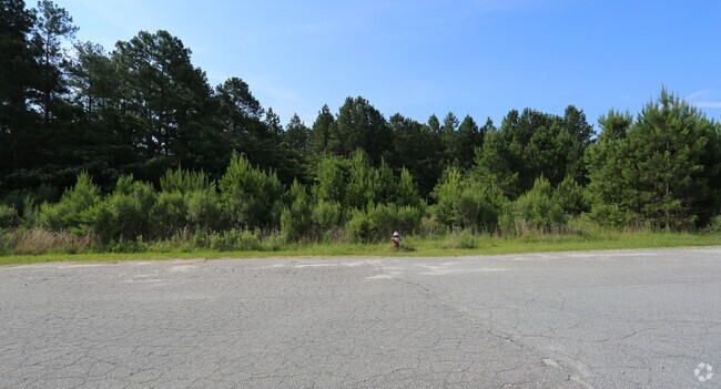
Commercialacreage
Lexington
X
South Carolina
45063C0040J
4.70 AC
2025
Dutch Fork/Irmo
2024
Columbia
021204
Columbia, SC
DEMOGRAPHICS near 460 E Boundary St
1 mile
3 mile
5 mile
2024 Total Population
2,007
9,484
26,936
2029 Population
2,194
10,298
28,856
Pop Growth 2024-2029
+ 9.32%
+ 8.58%
+ 7.13%
Average Age
39
40
42
2024 Total Households
759
3,537
10,104
HH Growth 2024-2029
+ 9.35%
+ 8.65%
+ 7.32%
Median Household Inc
$70,989
$73,462
$99,346
Avg Household Size
2.60
2.60
2.60
2024 Avg HH Vehicles
2.00
2.00
2.00
Median Home Value
$220,106
$255,166
$321,167
Median Year Built
2002
2000
2001
Nearby Places
Map Layers
Map Styles
 Street
 Aerial
Transit
 Traffic
 Biking
Places
Listings with unknown addresses are not visible on the map
- Restaurants
- Banks
- Shops
- Fitness
- Groceries
PUBLIC TRANSPORTATION
AIRPORT
Columbia Metro
Drive
Walk
Distance
Columbia Metro
46 min
28.5 mi
Freight Ports
North Charleston Terminal
Drive
Walk
Distance
North Charleston Terminal
146 min
124.8 mi
SALE & LEASE HISTORY
LISTING DATE
SALE/LEASE

Jun 21, 2017
For Sale
Nearby Properties
Address
Land Use
TOTAL SIZE
Lot Size
Zoning
Address
Land Use
TOTAL SIZE
Lot Size
Zoning
20,344 SF
13.21 AC
RU
Address
Land Use
TOTAL SIZE
Lot Size
Zoning
10,764 SF
1.84 AC
GC
Address
Land Use
TOTAL SIZE
Lot Size
Zoning
60.57 AC
RU
Address
Land Use
TOTAL SIZE
Lot Size
Zoning
87.84 AC
Address
Land Use
TOTAL SIZE
Lot Size
Zoning
4,824 SF
4.28 AC
RU
Address
Land Use
TOTAL SIZE
Lot Size
Zoning
46,031 SF
12.16 AC
GC
Address
Land Use
TOTAL SIZE
Lot Size
Zoning
2,402 SF
6.53 AC
RU
Address
Land Use
TOTAL SIZE
Lot Size
Zoning
4,044 SF
6.12 AC
RU
Address
Land Use
TOTAL SIZE
Lot Size
Zoning
3,320 SF
5.69 AC
RU
Address
Land Use
TOTAL SIZE
Lot Size
Zoning
88 AC
RU
Address
Land Use
TOTAL SIZE
Lot Size
Zoning
4,463 SF
5 AC
RU
Address
Land Use
TOTAL SIZE
Lot Size
Zoning
3,163 SF
2 AC
RU
Address
Land Use
TOTAL SIZE
Lot Size
Zoning
4,400 SF
5.14 AC
RU
Address
Land Use
TOTAL SIZE
Lot Size
Zoning
6,028 SF
0.26 AC
PDD
Address
Land Use
TOTAL SIZE
Lot Size
Zoning
2,746 SF
2.13 AC
RU
Address
Land Use
TOTAL SIZE
Lot Size
Zoning
3,507 SF
9.54 AC
RU
Address
Land Use
TOTAL SIZE
Lot Size
Zoning
3,435 SF
0.22 AC
PDD
Address
Land Use
TOTAL SIZE
Lot Size
Zoning
2,991 SF
0.42 AC
PDD
Address
Land Use
TOTAL SIZE
Lot Size
Zoning
6,368 SF
12 AC
RU
Address
Land Use
TOTAL SIZE
Lot Size
Zoning
2,402 SF
4.30 AC
RU
Address
Land Use
TOTAL SIZE
Lot Size
Zoning
2,806 SF
6.10 AC
RU
Address
Land Use
TOTAL SIZE
Lot Size
Zoning
960 SF
45 AC
RU
Address
Land Use
TOTAL SIZE
Lot Size
Zoning
4,181 SF
11.12 AC
RU
Address
Land Use
TOTAL SIZE
Lot Size
Zoning
2,672 SF
2.62 AC
RU
Address
Land Use
TOTAL SIZE
Lot Size
Zoning
4,708 SF
0.23 AC
PDD
Address
Land Use
TOTAL SIZE
Lot Size
Zoning
6,358 SF
17.11 AC
RU
Address
Land Use
TOTAL SIZE
Lot Size
Zoning
2,978 SF
0.32 AC
PDD
Address
Land Use
TOTAL SIZE
Lot Size
Zoning
2,694 SF
8 AC
RU
Address
Land Use
TOTAL SIZE
Lot Size
Zoning
3,446 SF
7.66 AC
RU
Address
Land Use
TOTAL SIZE
Lot Size
Zoning
5,451 SF
3.99 AC
RU
The World's #1 Commercial Real Estate Marketplace
Connect with us
© 2026 CoStar Group
The information above has been obtained from sources believed reliable. While we do not doubt its accuracy we have not verified it and make no guarantee, warranty or representation about it. It is your responsibility to independently confirm its accuracy and completeness. Any projections, opinions, assumptions, or estimates used are for example only and do not represent the current or future performance of the property. The value of this transaction to you depends on tax and other factors which should be evaluated by your tax, financial, and legal advisors. You and your advisors should conduct a careful, independent investigation of the property to determine to your satisfaction the suitability of the property for your needs.