Property Record
460 E Moorestown Rd, Wind Gap, PA 18091
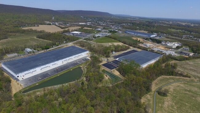

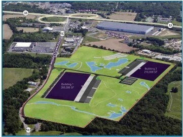
Property Detail
460 E Moorestown Rd
Commercialcondominium
NORTHAMPTON
GC/I
Pennsylvania
B and X Area of moderate flood hazard, usually the area between the limits of the 100-year and 500-year floods.
25.69 AC
2026
Lehigh Valley
2026
Philadelphia
015802
Allentown-Bethlehem-Easton, PA-NJ
222,574 SF
F7 17 10D 0406
NEARBY LISTINGS FOR SALE OR LEASE
DEMOGRAPHICS near 460 E Moorestown Rd
1 mile
3 mile
5 mile
2025 Total Population
1,141
9,275
26,468
2030 Population
1,175
9,405
26,812
Pop Growth 2025-2030
+ 2.98%
+ 1.40%
+ 1.30%
Average Age
45
45
45
2025 Total Households
427
3,686
10,323
HH Growth 2025-2030
+ 3.04%
+ 1.44%
+ 1.43%
Median Household Inc
$76,736
$82,276
$85,003
Avg Household Size
2.60
2.50
2.50
2025 Avg HH Vehicles
2.00
2.00
2.00
Median Home Value
$299,999
$334,338
$341,752
Median Year Built
1975
1973
1974
Nearby Places
Map Layers
Map Styles
 Street
 Aerial
Transit
 Traffic
 Biking
Places
Listings with unknown addresses are not visible on the map
- Restaurants
- Banks
- Shops
- Fitness
- Groceries
PUBLIC TRANSPORTATION
AIRPORT
Lehigh Valley International
Drive
Walk
Distance
Lehigh Valley International
26 min
16.0 mi
Freight Ports
Port of Philadelphia
Drive
Walk
Distance
Port of Philadelphia
110 min
71.3 mi
SALE & LEASE HISTORY
LISTING DATE
SALE/LEASE

Sep 18, 2018
For Lease
Nearby Properties
Address
Land Use
TOTAL SIZE
Lot Size
Zoning
Address
Land Use
TOTAL SIZE
Lot Size
Zoning
430,352 SF
57.60 AC
GC/I
Address
Land Use
TOTAL SIZE
Lot Size
Zoning
13,872 SF
23.48 AC
IE
Address
Land Use
TOTAL SIZE
Lot Size
Zoning
352,026 SF
1.84 AC
GC/I
Address
Land Use
TOTAL SIZE
Lot Size
Zoning
349,517 SF
28.20 AC
HI
Address
Land Use
TOTAL SIZE
Lot Size
Zoning
324,240 SF
13.95 AC
HI
Address
Land Use
TOTAL SIZE
Lot Size
Zoning
12,355 SF
2,230.15 AC
E
Address
Land Use
TOTAL SIZE
Lot Size
Zoning
69,548 SF
9.18 AC
GC/I
Address
Land Use
TOTAL SIZE
Lot Size
Zoning
6,200 SF
345.07 AC
FF
Address
Land Use
TOTAL SIZE
Lot Size
Zoning
120,747 SF
22.45 AC
R12
Address
Land Use
TOTAL SIZE
Lot Size
Zoning
55,069 SF
6.77 AC
IC
Address
Land Use
TOTAL SIZE
Lot Size
Zoning
82,626 SF
18.96 AC
MDR
Address
Land Use
TOTAL SIZE
Lot Size
Zoning
18,582 SF
26.11 AC
SR
Address
Land Use
TOTAL SIZE
Lot Size
Zoning
37,164 SF
2.73 AC
HI
Address
Land Use
TOTAL SIZE
Lot Size
Zoning
118,536 SF
14.36 AC
GCI
Address
Land Use
TOTAL SIZE
Lot Size
Zoning
48,084 SF
7.96 AC
RA
Address
Land Use
TOTAL SIZE
Lot Size
Zoning
34,781 SF
167.39 AC
FF
Address
Land Use
TOTAL SIZE
Lot Size
Zoning
1,050 SF
4.48 AC
PR
Address
Land Use
TOTAL SIZE
Lot Size
Zoning
5,106 SF
60.79 AC
RA
Address
Land Use
TOTAL SIZE
Lot Size
Zoning
18,710 SF
26.90 AC
GC
Address
Land Use
TOTAL SIZE
Lot Size
Zoning
50,000 SF
5.17 AC
1C
Address
Land Use
TOTAL SIZE
Lot Size
Zoning
118,536 SF
8.17 AC
GCI
Address
Land Use
TOTAL SIZE
Lot Size
Zoning
95,160 SF
14.33 AC
IC
Address
Land Use
TOTAL SIZE
Lot Size
Zoning
380.48 AC
RC
Address
Land Use
TOTAL SIZE
Lot Size
Zoning
17,609 SF
5.23 AC
R8
Address
Land Use
TOTAL SIZE
Lot Size
Zoning
24,194 SF
2.25 AC
GC/I
Address
Land Use
TOTAL SIZE
Lot Size
Zoning
53,019 SF
3.82 AC
1C
Address
Land Use
TOTAL SIZE
Lot Size
Zoning
346.73 AC
RC
Address
Land Use
TOTAL SIZE
Lot Size
Zoning
298.49 AC
RC
Address
Land Use
TOTAL SIZE
Lot Size
Zoning
5,024 SF
5.31 AC
GC
The World's #1 Commercial Real Estate Marketplace
Connect with us
© 2026 CoStar Group
The information above has been obtained from sources believed reliable. While we do not doubt its accuracy we have not verified it and make no guarantee, warranty or representation about it. It is your responsibility to independently confirm its accuracy and completeness. Any projections, opinions, assumptions, or estimates used are for example only and do not represent the current or future performance of the property. The value of this transaction to you depends on tax and other factors which should be evaluated by your tax, financial, and legal advisors. You and your advisors should conduct a careful, independent investigation of the property to determine to your satisfaction the suitability of the property for your needs.