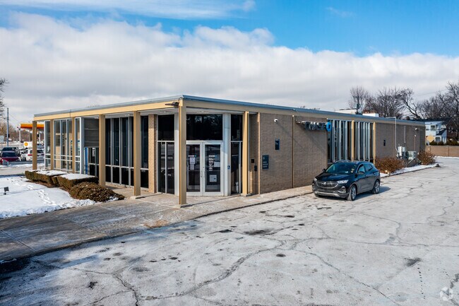
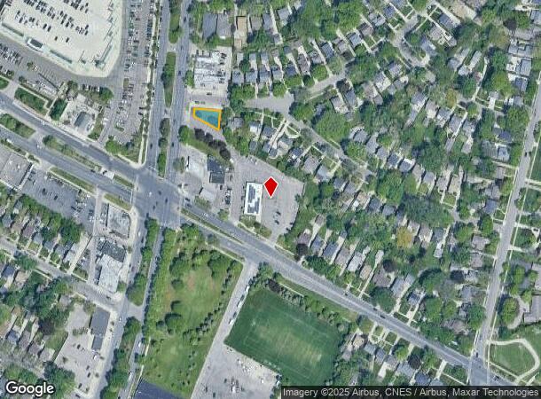
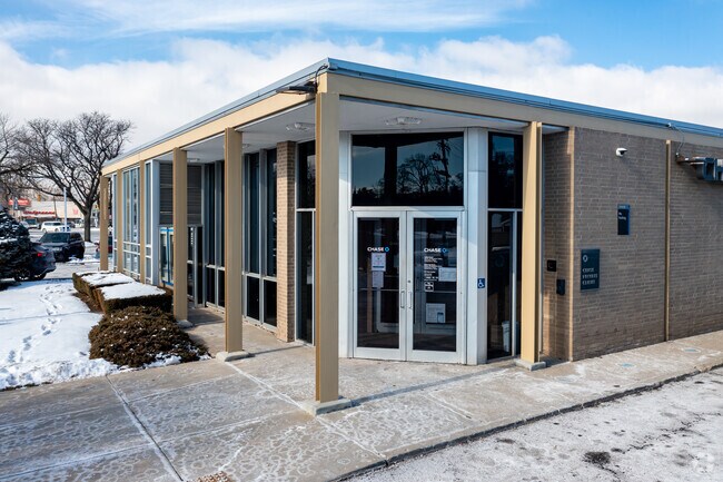
Property Record
460 Moross Rd, Grosse Pointe Farms, MI 48236
NEARBY LISTINGS FOR SALE OR LEASE
Property Detail
460 Moross Rd
Detroit-Warren-Dearborn, MI
Country Club Park No 1
38-001-01-0188-001
FMA188A LOT 188 EXCEPT THE ELY 10 FT THEREOF THE COUNTRY CLUB PARK SUB NO 1 PC 123 617 L61 P42 WCR
Commercialacreage
Wayne
X
Michigan
26163C0141F
188
2024
0.06 AC
2025
The Pointes/Harper Woods
550800
Detroit
DEMOGRAPHICS near 460 Moross Rd
1 Mile
3 Mile
5 Mile
2024 Total Population
13,955
115,728
250,236
2029 Population
13,443
113,123
248,659
Pop Growth 2024-2029
(3.67%)
(2.25%)
(0.63%)
Average Age
41
39
39
2024 Total Households
5,458
43,846
96,542
HH Growth 2024-2029
(3.72%)
(2.39%)
(0.78%)
Median Household Inc
$86,631
$63,691
$52,463
Avg Household Size
2.50
2.60
2.50
2024 Avg HH Vehicles
2.00
2.00
1.00
Median Home Value
$267,128
$192,960
$141,928
Median Year Built
1951
1950
1952
Nearby Places
Map Layers
Map Styles
 Street
 Aerial
- Restaurants
- Banks
- Shops
- Fitness
- Groceries
PUBLIC TRANSPORTATION
AIRPORT
Windsor International
DRIVE
WALK
Distance
Windsor International
42 min
21.5 mi
Detroit Metro Wayne County
DRIVE
WALK
Distance
Detroit Metro Wayne County
45 min
31.1 mi
Freight Ports
Port of Toledo
DRIVE
WALK
Distance
Port of Toledo
91 min
71.8 mi
Nearby Properties
Address
Land Use
TOTAL SIZE
Lot Size
Zoning
Address
Land Use
TOTAL SIZE
Lot Size
Zoning
1,034,990 SF
28.60 AC
Address
Land Use
TOTAL SIZE
Lot Size
Zoning
211,065 SF
8.84 AC
C.F
Address
Land Use
TOTAL SIZE
Lot Size
Zoning
575,081 SF
8.53 AC
R6
Address
Land Use
TOTAL SIZE
Lot Size
Zoning
101,733 SF
1.10 AC
C-2
Address
Land Use
TOTAL SIZE
Lot Size
Zoning
49,437 SF
0.47 AC
Address
Land Use
TOTAL SIZE
Lot Size
Zoning
93,296 SF
1.05 AC
C-2
Address
Land Use
TOTAL SIZE
Lot Size
Zoning
62,195 SF
1.50 AC
Address
Land Use
TOTAL SIZE
Lot Size
Zoning
75,284 SF
0.87 AC
C
Address
Land Use
TOTAL SIZE
Lot Size
Zoning
17,558 SF
3.15 AC
Address
Land Use
TOTAL SIZE
Lot Size
Zoning
41,000 SF
C-1
Address
Land Use
TOTAL SIZE
Lot Size
Zoning
5,511 SF
1.52 AC
Address
Land Use
TOTAL SIZE
Lot Size
Zoning
41,235 SF
8.81 AC
Address
Land Use
TOTAL SIZE
Lot Size
Zoning
30,919 SF
0.86 AC
C
Address
Land Use
TOTAL SIZE
Lot Size
Zoning
28,055 SF
0.44 AC
Address
Land Use
TOTAL SIZE
Lot Size
Zoning
80,320 SF
4.73 AC
RM-1
Address
Land Use
TOTAL SIZE
Lot Size
Zoning
42,113 SF
0.54 AC
Address
Land Use
TOTAL SIZE
Lot Size
Zoning
102,205 SF
214.30 AC
Address
Land Use
TOTAL SIZE
Lot Size
Zoning
20,625 SF
0.48 AC
C-2
Address
Land Use
TOTAL SIZE
Lot Size
Zoning
36,191 SF
3.87 AC
B-2
Address
Land Use
TOTAL SIZE
Lot Size
Zoning
3,312 SF
8.81 AC
R-1A
Address
Land Use
TOTAL SIZE
Lot Size
Zoning
10,704 SF
1.84 AC
Address
Land Use
TOTAL SIZE
Lot Size
Zoning
25,500 SF
0.23 AC
Address
Land Use
TOTAL SIZE
Lot Size
Zoning
101,814 SF
3.74 AC
R-2
Address
Land Use
TOTAL SIZE
Lot Size
Zoning
60,484 SF
4.85 AC
PD
Address
Land Use
TOTAL SIZE
Lot Size
Zoning
38,577 SF
1.91 AC
C
Address
Land Use
TOTAL SIZE
Lot Size
Zoning
43,967 SF
2.80 AC
O-1
Address
Land Use
TOTAL SIZE
Lot Size
Zoning
137,284 SF
13.55 AC
RS-1
Address
Land Use
TOTAL SIZE
Lot Size
Zoning
33,646 SF
1.83 AC
B-1
Address
Land Use
TOTAL SIZE
Lot Size
Zoning
37.36 AC
RS-1
Address
Land Use
TOTAL SIZE
Lot Size
Zoning
14,820 SF
0.41 AC
C-1
The World's #1 Commercial Real Estate Marketplace
Connect with us
© 2025 CoStar Group
The information above has been obtained from sources believed reliable. While we do not doubt its accuracy we have not verified it and make no guarantee, warranty or representation about it. It is your responsibility to independently confirm its accuracy and completeness. Any projections, opinions, assumptions, or estimates used are for example only and do not represent the current or future performance of the property. The value of this transaction to you depends on tax and other factors which should be evaluated by your tax, financial, and legal advisors. You and your advisors should conduct a careful, independent investigation of the property to determine to your satisfaction the suitability of the property for your needs.