Property Record
460 Rodi Rd, Pittsburgh, PA 15235

NEARBY LISTINGS FOR SALE OR LEASE
Property Detail
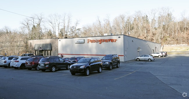
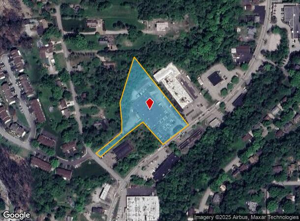
460 Rodi Rd
Pittsburgh, PA
Weaver Plan
0450-P-00020-0000-00
WEAVER PLAN #2 IRREG LOT 200.39X499.96X292.59 (OR 2.51 AC LD) RODI RD 1 STY BRK & C B OFF & WHSE #440
Warehouse
Allegheny
X
Pennsylvania
42003C0380H
20
2024
2.51 AC
2025
Parkway East Corridor
523400
Pittsburgh
DEMOGRAPHICS near 460 Rodi Rd
1 Mile
3 Mile
5 Mile
2024 Total Population
8,861
71,885
193,741
2029 Population
8,637
70,685
191,232
Pop Growth 2024-2029
(2.53%)
(1.67%)
(1.30%)
Average Age
44
44
43
2024 Total Households
4,089
33,636
90,258
HH Growth 2024-2029
(2.62%)
(1.74%)
(1.36%)
Median Household Inc
$57,902
$58,431
$56,678
Avg Household Size
2.10
2.10
2.10
2024 Avg HH Vehicles
2.00
1.00
1.00
Median Home Value
$115,432
$134,102
$150,642
Median Year Built
1957
1957
1955
Nearby Places
Map Layers
Map Styles
 Street
 Aerial
- Restaurants
- Banks
- Shops
- Fitness
- Groceries
SALE & LEASE HISTORY
LISTING DATE
SALE/LEASE

Jul 24, 2017
For Sale
Aug 18, 2022
For Sale
Aug 08, 2017
For Lease
Apr 08, 2019
For Sale
Nearby Properties
Address
Land Use
TOTAL SIZE
Lot Size
Zoning
Address
Land Use
TOTAL SIZE
Lot Size
Zoning
58.96 AC
Address
Land Use
TOTAL SIZE
Lot Size
Zoning
Address
Land Use
TOTAL SIZE
Lot Size
Zoning
42.65 AC
Address
Land Use
TOTAL SIZE
Lot Size
Zoning
34.65 AC
Address
Land Use
TOTAL SIZE
Lot Size
Zoning
6.61 AC
Address
Land Use
TOTAL SIZE
Lot Size
Zoning
42.24 AC
Address
Land Use
TOTAL SIZE
Lot Size
Zoning
148.17 AC
Address
Land Use
TOTAL SIZE
Lot Size
Zoning
Address
Land Use
TOTAL SIZE
Lot Size
Zoning
Address
Land Use
TOTAL SIZE
Lot Size
Zoning
15.99 AC
Address
Land Use
TOTAL SIZE
Lot Size
Zoning
20.86 AC
Address
Land Use
TOTAL SIZE
Lot Size
Zoning
5.63 AC
Address
Land Use
TOTAL SIZE
Lot Size
Zoning
Address
Land Use
TOTAL SIZE
Lot Size
Zoning
1.48 AC
Address
Land Use
TOTAL SIZE
Lot Size
Zoning
Address
Land Use
TOTAL SIZE
Lot Size
Zoning
66.40 AC
Address
Land Use
TOTAL SIZE
Lot Size
Zoning
5.06 AC
Address
Land Use
TOTAL SIZE
Lot Size
Zoning
Address
Land Use
TOTAL SIZE
Lot Size
Zoning
2.38 AC
Address
Land Use
TOTAL SIZE
Lot Size
Zoning
Address
Land Use
TOTAL SIZE
Lot Size
Zoning
20.31 AC
Address
Land Use
TOTAL SIZE
Lot Size
Zoning
Address
Land Use
TOTAL SIZE
Lot Size
Zoning
14.21 AC
Address
Land Use
TOTAL SIZE
Lot Size
Zoning
Address
Land Use
TOTAL SIZE
Lot Size
Zoning
Address
Land Use
TOTAL SIZE
Lot Size
Zoning
8.04 AC
Address
Land Use
TOTAL SIZE
Lot Size
Zoning
12.93 AC
Address
Land Use
TOTAL SIZE
Lot Size
Zoning
15.77 AC
Address
Land Use
TOTAL SIZE
Lot Size
Zoning
975 SF
34.76 AC
Address
Land Use
TOTAL SIZE
Lot Size
Zoning
6.30 AC
The World's #1 Commercial Real Estate Marketplace
Connect with us
© 2025 CoStar Group
The information above has been obtained from sources believed reliable. While we do not doubt its accuracy we have not verified it and make no guarantee, warranty or representation about it. It is your responsibility to independently confirm its accuracy and completeness. Any projections, opinions, assumptions, or estimates used are for example only and do not represent the current or future performance of the property. The value of this transaction to you depends on tax and other factors which should be evaluated by your tax, financial, and legal advisors. You and your advisors should conduct a careful, independent investigation of the property to determine to your satisfaction the suitability of the property for your needs.