Property Record
460 S Aguilar Dr, Pueblo, CO 81007

Save to a Folder
{{folder.Name}}
{{folder.ListingIds.length}} Properties
{{folder.ListingIds.length}} Property
Create a New Folder
Property Detail
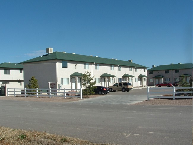
460 S Aguilar Dr
0-6-14-1-01-002
LOT 1 BLK 1 TR 333 PUEBLO WEST
Multifamilydwelling
PUEBLO
R-5
Colorado
B and X Area of moderate flood hazard, usually the area between the limits of the 100-year and 500-year floods.
1
2024
1.11 AC
2024
Colorado East Area
002914
Other Market Areas
18,216 SF
Pueblo, CO
NEARBY LISTINGS FOR SALE OR LEASE
DEMOGRAPHICS near 460 S Aguilar Dr
1 mile
3 mile
5 mile
2025 Total Population
6,787
20,446
31,094
2030 Population
6,750
20,351
31,077
Pop Growth 2025-2030
(0.55%)
(0.46%)
(0.05%)
Average Age
39
41
42
2025 Total Households
2,547
7,662
11,550
HH Growth 2025-2030
(0.55%)
(0.48%)
(0.04%)
Median Household Inc
$91,311
$97,731
$96,765
Avg Household Size
2.60
2.60
2.60
2025 Avg HH Vehicles
2.00
2.00
2.00
Median Home Value
$340,337
$372,949
$382,782
Median Year Built
1994
1996
1997
Nearby Places
Map Layers
Map Styles
 Street
 Aerial
Layers
 Traffic
 Biking
Places
Listings with unknown addresses are not visible on the map
- Restaurants
- Banks
- Shops
- Fitness
- Groceries
Nearby Properties
Address
Land Use
TOTAL SIZE
Lot Size
Zoning
Address
Land Use
TOTAL SIZE
Lot Size
Zoning
78,127 SF
34.84 AC
R-5
Address
Land Use
TOTAL SIZE
Lot Size
Zoning
60,593 SF
12.69 AC
Address
Land Use
TOTAL SIZE
Lot Size
Zoning
221,954 SF
24.02 AC
B-4
Address
Land Use
TOTAL SIZE
Lot Size
Zoning
15,284 SF
4.50 AC
R6:RES/MUL
Address
Land Use
TOTAL SIZE
Lot Size
Zoning
33,098 SF
5 AC
B4:COMM/RE
Address
Land Use
TOTAL SIZE
Lot Size
Zoning
34,494 SF
3.87 AC
R5:RES/MUL
Address
Land Use
TOTAL SIZE
Lot Size
Zoning
86,025 SF
5.83 AC
I-2
Address
Land Use
TOTAL SIZE
Lot Size
Zoning
8,166 SF
8.27 AC
R-6
Address
Land Use
TOTAL SIZE
Lot Size
Zoning
7,495 SF
2.99 AC
R5:RES/MUL
Address
Land Use
TOTAL SIZE
Lot Size
Zoning
51,856 SF
6.01 AC
Address
Land Use
TOTAL SIZE
Lot Size
Zoning
107,280 SF
6.22 AC
I-2
Address
Land Use
TOTAL SIZE
Lot Size
Zoning
3,146 SF
46.55 AC
S1:SPC/PUB
Address
Land Use
TOTAL SIZE
Lot Size
Zoning
37.11 AC
S1:SPC/PUB
Address
Land Use
TOTAL SIZE
Lot Size
Zoning
33.01 AC
S1:SPC/PUB
Address
Land Use
TOTAL SIZE
Lot Size
Zoning
22,077 SF
13.98 AC
S1:SPC/PUB
Address
Land Use
TOTAL SIZE
Lot Size
Zoning
29,720 SF
2.28 AC
B4:COMM/RE
Address
Land Use
TOTAL SIZE
Lot Size
Zoning
62,080 SF
6.22 AC
I-2
Address
Land Use
TOTAL SIZE
Lot Size
Zoning
30.47 AC
S1:SPC/PUB
Address
Land Use
TOTAL SIZE
Lot Size
Zoning
10,030 SF
1.72 AC
B4:COMM/RE
Address
Land Use
TOTAL SIZE
Lot Size
Zoning
20.39 AC
I2:IND/MAN
Address
Land Use
TOTAL SIZE
Lot Size
Zoning
56,140 SF
5.60 AC
B4:COMM/RE
Address
Land Use
TOTAL SIZE
Lot Size
Zoning
19.74 AC
I2:IND/MAN
Address
Land Use
TOTAL SIZE
Lot Size
Zoning
28,480 SF
10.78 AC
I2:IND/MAN
Address
Land Use
TOTAL SIZE
Lot Size
Zoning
19.41 AC
I2:IND/MAN
Address
Land Use
TOTAL SIZE
Lot Size
Zoning
32.46 AC
B4:COMM/RE
Address
Land Use
TOTAL SIZE
Lot Size
Zoning
3,929 SF
0.28 AC
R3:RES/2 F
Address
Land Use
TOTAL SIZE
Lot Size
Zoning
54,100 SF
4.60 AC
I2:IND/MAN
Address
Land Use
TOTAL SIZE
Lot Size
Zoning
57,640 SF
8.96 AC
R6:RES/MUL
Address
Land Use
TOTAL SIZE
Lot Size
Zoning
3,907 SF
0.28 AC
R3:RES/2 F
Address
Land Use
TOTAL SIZE
Lot Size
Zoning
5,682 SF
4.23 AC
R6:RES/MUL
The World's #1 Commercial Real Estate Marketplace
Connect with us
© 2026 CoStar Group
The information above has been obtained from sources believed reliable. While we do not doubt its accuracy we have not verified it and make no guarantee, warranty or representation about it. It is your responsibility to independently confirm its accuracy and completeness. Any projections, opinions, assumptions, or estimates used are for example only and do not represent the current or future performance of the property. The value of this transaction to you depends on tax and other factors which should be evaluated by your tax, financial, and legal advisors. You and your advisors should conduct a careful, independent investigation of the property to determine to your satisfaction the suitability of the property for your needs.