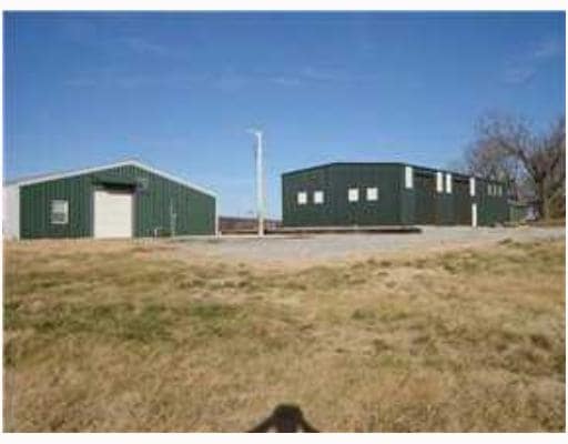
Property Record
4600 Butterfield Coach Rd, Springdale, AR 72764
NEARBY LISTINGS FOR SALE OR LEASE
Property Detail
4600 Butterfield Coach Rd
Fayetteville-Springdale-Rogers, AR-MO
Archie's Place
815-39879-000
ANNEXED TO CITY OF SPRINGDALE FOR 2022 & FOLLOWING YEARS PER ANNEXATION ORDER 5662 TRACT C2 NORTH PER REPLAT OF TRACT C ARCHI
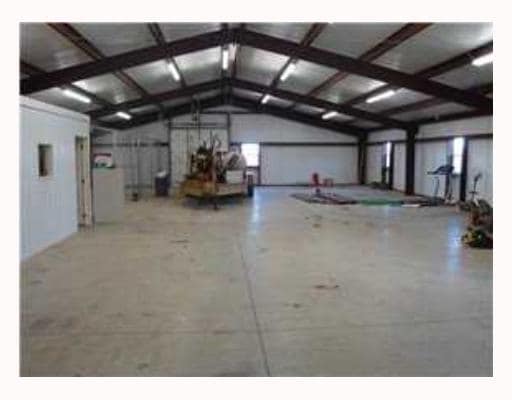
Warehouse
Washington
2025
Arkansas
2025
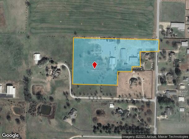
7.06 AC
010108
Outlying Washington Cnty
2,820 SF
Fayetteville/Springdale/Rogers
DEMOGRAPHICS near 4600 Butterfield Coach Rd
1 Mile
3 Mile
5 Mile
2024 Total Population
3,402
42,423
99,311
2029 Population
3,741
46,648
108,706
Pop Growth 2024-2029
+ 9.96%
+ 9.96%
+ 9.46%
Average Age
38
35
36
2024 Total Households
1,180
14,318
35,134
HH Growth 2024-2029
+ 10.25%
+ 10.16%
+ 9.61%
Median Household Inc
$101,446
$65,471
$65,755
Avg Household Size
2.70
2.90
2.70
2024 Avg HH Vehicles
2.00
2.00
2.00
Median Home Value
$271,465
$244,688
$242,780
Median Year Built
2004
1996
1993
Nearby Places
Map Layers
Map Styles
 Street
 Aerial
- Restaurants
- Banks
- Shops
- Fitness
- Groceries
PUBLIC TRANSPORTATION
AIRPORT
Northwest Arkansas Ntl
DRIVE
WALK
Distance
Northwest Arkansas Ntl
41 min
19.6 mi
Freight Ports
Tulsa Port of Inola
DRIVE
WALK
Distance
Tulsa Port of Inola
110 min
91.0 mi
Nearby Properties
Address
Land Use
TOTAL SIZE
Lot Size
Zoning
Address
Land Use
TOTAL SIZE
Lot Size
Zoning
481,800 SF
40 AC
Address
Land Use
TOTAL SIZE
Lot Size
Zoning
23,707 SF
15.45 AC
R2
Address
Land Use
TOTAL SIZE
Lot Size
Zoning
232,212 SF
10.31 AC
Address
Land Use
TOTAL SIZE
Lot Size
Zoning
567,022 SF
88.88 AC
C2
Address
Land Use
TOTAL SIZE
Lot Size
Zoning
6,798 SF
10.56 AC
Address
Land Use
TOTAL SIZE
Lot Size
Zoning
41,952 SF
19.26 AC
Address
Land Use
TOTAL SIZE
Lot Size
Zoning
178,014 SF
6.43 AC
Address
Land Use
TOTAL SIZE
Lot Size
Zoning
261,670 SF
16.72 AC
R2
Address
Land Use
TOTAL SIZE
Lot Size
Zoning
4,941 SF
10.87 AC
Address
Land Use
TOTAL SIZE
Lot Size
Zoning
156,072 SF
12.43 AC
Address
Land Use
TOTAL SIZE
Lot Size
Zoning
56,672 SF
0.53 AC
R0
Address
Land Use
TOTAL SIZE
Lot Size
Zoning
178,140 SF
4.39 AC
Address
Land Use
TOTAL SIZE
Lot Size
Zoning
117,196 SF
9.74 AC
Address
Land Use
TOTAL SIZE
Lot Size
Zoning
66,120 SF
1.95 AC
Address
Land Use
TOTAL SIZE
Lot Size
Zoning
73,436 SF
16.01 AC
I1
Address
Land Use
TOTAL SIZE
Lot Size
Zoning
55,877 SF
6.43 AC
C2
Address
Land Use
TOTAL SIZE
Lot Size
Zoning
61,431 SF
1.62 AC
C2
Address
Land Use
TOTAL SIZE
Lot Size
Zoning
69,412 SF
8.81 AC
R0
Address
Land Use
TOTAL SIZE
Lot Size
Zoning
63,688 SF
8.24 AC
Address
Land Use
TOTAL SIZE
Lot Size
Zoning
111,342 SF
8.35 AC
R2
Address
Land Use
TOTAL SIZE
Lot Size
Zoning
63,197 SF
2.50 AC
R0
Address
Land Use
TOTAL SIZE
Lot Size
Zoning
75,866 SF
5.86 AC
C2
Address
Land Use
TOTAL SIZE
Lot Size
Zoning
116,736 SF
10.95 AC
Address
Land Use
TOTAL SIZE
Lot Size
Zoning
177,864 SF
18.04 AC
Address
Land Use
TOTAL SIZE
Lot Size
Zoning
123,243 SF
15.99 AC
C2
Address
Land Use
TOTAL SIZE
Lot Size
Zoning
10,044 SF
11.76 AC
Address
Land Use
TOTAL SIZE
Lot Size
Zoning
29,121 SF
6 AC
R0
Address
Land Use
TOTAL SIZE
Lot Size
Zoning
74,434 SF
32.25 AC
Address
Land Use
TOTAL SIZE
Lot Size
Zoning
46,701 SF
4.10 AC
Address
Land Use
TOTAL SIZE
Lot Size
Zoning
107,950 SF
6.68 AC
C2
The World's #1 Commercial Real Estate Marketplace
Connect with us
© 2026 CoStar Group
The information above has been obtained from sources believed reliable. While we do not doubt its accuracy we have not verified it and make no guarantee, warranty or representation about it. It is your responsibility to independently confirm its accuracy and completeness. Any projections, opinions, assumptions, or estimates used are for example only and do not represent the current or future performance of the property. The value of this transaction to you depends on tax and other factors which should be evaluated by your tax, financial, and legal advisors. You and your advisors should conduct a careful, independent investigation of the property to determine to your satisfaction the suitability of the property for your needs.