Property Record
4600 E 10Th St, Greenville, NC 27858


Property Detail
4600 E 10Th St
081184
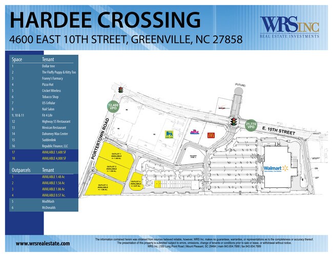
HARDEE CROSSING AT PORTER
Wholesaleoutletdiscountstore
PITT
CG
North Carolina
B and X Area of moderate flood hazard, usually the area between the limits of the 100-year and 500-year floods.
7
2025
18.92 AC
2025
North Carolina Northeast Area
001002
Other Market Areas
145,476 SF
Greenville, NC
NEARBY LISTINGS FOR SALE OR LEASE
DEMOGRAPHICS near 4600 E 10Th St
1 mile
3 mile
5 mile
2025 Total Population
5,204
32,996
83,836
2030 Population
5,323
34,063
87,218
Pop Growth 2025-2030
+ 2.29%
+ 3.23%
+ 4.03%
Average Age
39
38
36
2025 Total Households
1,958
14,000
33,894
HH Growth 2025-2030
+ 2.40%
+ 3.52%
+ 4.57%
Median Household Inc
$95,958
$71,513
$60,029
Avg Household Size
2.60
2.30
2.20
2025 Avg HH Vehicles
2.00
2.00
2.00
Median Home Value
$287,585
$260,916
$264,719
Median Year Built
1991
1990
1991
Nearby Places
Map Layers
Map Styles
 Street
 Aerial
Layers
 Traffic
 Biking
Places
Listings with unknown addresses are not visible on the map
- Restaurants
- Banks
- Shops
- Fitness
- Groceries
PUBLIC TRANSPORTATION
AIRPORT
Pitt-Greenville
Drive
Walk
Distance
Pitt-Greenville
18 min
10.3 mi
Freight Ports
Port of Morehead City
Drive
Walk
Distance
Port of Morehead City
125 min
82.5 mi
SALE & LEASE HISTORY
LISTING DATE
SALE/LEASE

Sep 26, 2017
For Lease
Jan 24, 2017
For Lease
Jan 07, 2021
For Lease
Nearby Properties
Address
Land Use
TOTAL SIZE
Lot Size
Zoning
Address
Land Use
TOTAL SIZE
Lot Size
Zoning
33,791 SF
21.01 AC
OR
Address
Land Use
TOTAL SIZE
Lot Size
Zoning
24,032 SF
22.74 AC
R6
Address
Land Use
TOTAL SIZE
Lot Size
Zoning
24,161 SF
53.66 AC
R6A
Address
Land Use
TOTAL SIZE
Lot Size
Zoning
16,462 SF
30.51 AC
OR
Address
Land Use
TOTAL SIZE
Lot Size
Zoning
103,256 SF
8.80 AC
OR
Address
Land Use
TOTAL SIZE
Lot Size
Zoning
20,138 SF
26.90 AC
R6A
Address
Land Use
TOTAL SIZE
Lot Size
Zoning
31.04 AC
R6S
Address
Land Use
TOTAL SIZE
Lot Size
Zoning
55,402 SF
37.57 AC
RA20
Address
Land Use
TOTAL SIZE
Lot Size
Zoning
22,741 SF
24.70 AC
R6A
Address
Land Use
TOTAL SIZE
Lot Size
Zoning
23,113 SF
30.28 AC
R6A
Address
Land Use
TOTAL SIZE
Lot Size
Zoning
86,405 SF
15 AC
R9
Address
Land Use
TOTAL SIZE
Lot Size
Zoning
17,443 SF
24.97 AC
IU
Address
Land Use
TOTAL SIZE
Lot Size
Zoning
19,628 SF
7.06 AC
OR
Address
Land Use
TOTAL SIZE
Lot Size
Zoning
8,292 SF
10.73 AC
R6
Address
Land Use
TOTAL SIZE
Lot Size
Zoning
85,943 SF
5.42 AC
R6
Address
Land Use
TOTAL SIZE
Lot Size
Zoning
22,971 SF
6.02 AC
OR
Address
Land Use
TOTAL SIZE
Lot Size
Zoning
67,219 SF
5.98 AC
CG
Address
Land Use
TOTAL SIZE
Lot Size
Zoning
9,778 SF
19.61 AC
R6
Address
Land Use
TOTAL SIZE
Lot Size
Zoning
138,364 SF
18.19 AC
CH
Address
Land Use
TOTAL SIZE
Lot Size
Zoning
17,566 SF
6.49 AC
R6
Address
Land Use
TOTAL SIZE
Lot Size
Zoning
31,116 SF
19.98 AC
OR
Address
Land Use
TOTAL SIZE
Lot Size
Zoning
58,281 SF
7 AC
R6
Address
Land Use
TOTAL SIZE
Lot Size
Zoning
74,102 SF
11.50 AC
CG
Address
Land Use
TOTAL SIZE
Lot Size
Zoning
44,290 SF
10.75 AC
R9S
Address
Land Use
TOTAL SIZE
Lot Size
Zoning
20,155 SF
24.22 AC
RA20
Address
Land Use
TOTAL SIZE
Lot Size
Zoning
130,605 SF
10.89 AC
GC
Address
Land Use
TOTAL SIZE
Lot Size
Zoning
50,328 SF
6.58 AC
CG
Address
Land Use
TOTAL SIZE
Lot Size
Zoning
40,720 SF
8.32 AC
CG
Address
Land Use
TOTAL SIZE
Lot Size
Zoning
39,553 SF
6.34 AC
CG
The World's #1 Commercial Real Estate Marketplace
Connect with us
© 2026 CoStar Group
The information above has been obtained from sources believed reliable. While we do not doubt its accuracy we have not verified it and make no guarantee, warranty or representation about it. It is your responsibility to independently confirm its accuracy and completeness. Any projections, opinions, assumptions, or estimates used are for example only and do not represent the current or future performance of the property. The value of this transaction to you depends on tax and other factors which should be evaluated by your tax, financial, and legal advisors. You and your advisors should conduct a careful, independent investigation of the property to determine to your satisfaction the suitability of the property for your needs.