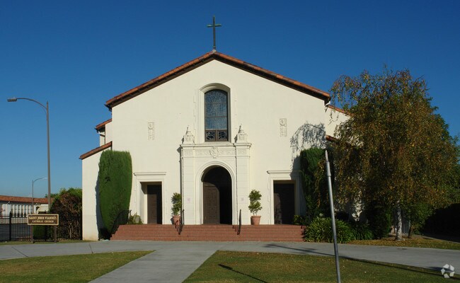
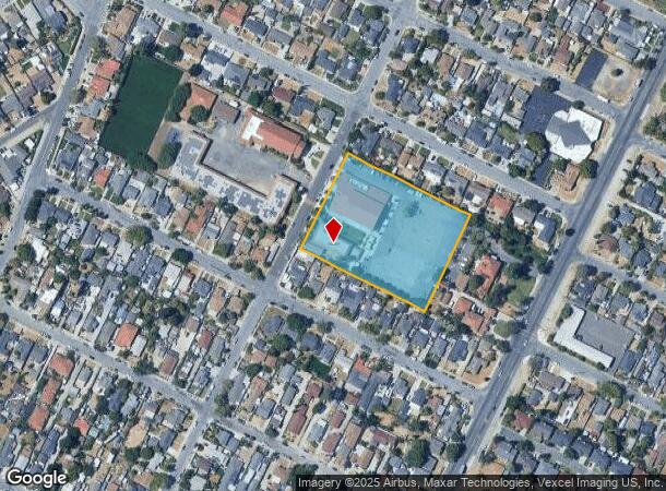
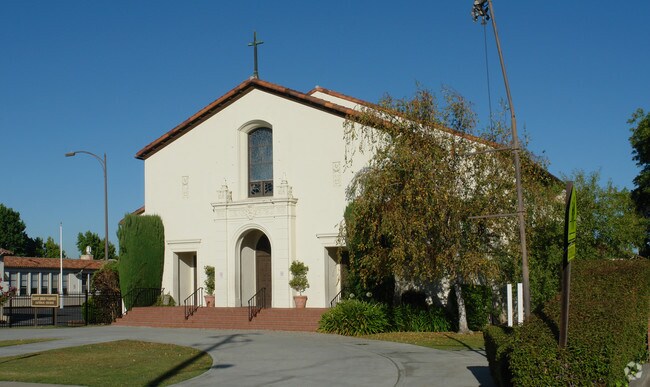
Property Record
4600 Hyland Ave, San Jose, CA 95127
NEARBY LISTINGS FOR SALE OR LEASE
-
-
View all San Jose listings for sale on LoopNet.com
Property Detail
4600 Hyland Ave
601-09-013
Maro
Religious
Santa Clara
X
California
06085C0252J
2.76 AC
2024
San Jose-Berryessa
2025
South Bay/San Jose
503902
San Jose-Sunnyvale-Santa Clara, CA
DEMOGRAPHICS near 4600 Hyland Ave
1 Mile
3 Mile
5 Mile
2024 Total Population
29,854
185,037
423,925
2029 Population
28,181
176,281
406,167
Pop Growth 2024-2029
(5.60%)
(4.73%)
(4.19%)
Average Age
39
39
39
2024 Total Households
8,104
49,113
122,942
HH Growth 2024-2029
(5.87%)
(5.01%)
(4.26%)
Median Household Inc
$98,555
$109,316
$116,112
Avg Household Size
3.50
3.50
3.20
2024 Avg HH Vehicles
3.00
2.00
2.00
Median Home Value
$801,123
$912,090
$950,225
Median Year Built
1963
1972
1976
Nearby Places
Map Layers
Map Styles
 Street
 Aerial
- Restaurants
- Banks
- Shops
- Fitness
- Groceries
PUBLIC TRANSPORTATION
COMMUTER RAIL
San Jose (Capitol Corridor - Capitol Corridor Joint Powers Authority)
DRIVE
WALK
Distance
San Jose (Capitol Corridor - Capitol Corridor Joint Powers Authority)
11 min
6.8 mi
San Jose Station (ACE Train - Altamont Corridor Express)
DRIVE
WALK
Distance
San Jose Station (ACE Train - Altamont Corridor Express)
11 min
6.9 mi
AIRPORT
Norman Y Mineta San Jose International
DRIVE
WALK
Distance
Norman Y Mineta San Jose International
13 min
8.0 mi
Freight Ports
Port of Redwood City
DRIVE
WALK
Distance
Port of Redwood City
35 min
26.1 mi
Nearby Properties
Address
Land Use
TOTAL SIZE
Lot Size
Zoning
Address
Land Use
TOTAL SIZE
Lot Size
Zoning
33.32 AC
R140
Address
Land Use
TOTAL SIZE
Lot Size
Zoning
3.74 AC
APD
Address
Land Use
TOTAL SIZE
Lot Size
Zoning
230,946 SF
2.86 AC
I
Address
Land Use
TOTAL SIZE
Lot Size
Zoning
2.78 AC
APD
Address
Land Use
TOTAL SIZE
Lot Size
Zoning
153,024 SF
8.11 AC
R3BPD
Address
Land Use
TOTAL SIZE
Lot Size
Zoning
116,044 SF
7 AC
C3PD
Address
Land Use
TOTAL SIZE
Lot Size
Zoning
3.98 AC
SJ
Address
Land Use
TOTAL SIZE
Lot Size
Zoning
335,832 SF
20.42 AC
R3AH
Address
Land Use
TOTAL SIZE
Lot Size
Zoning
269,680 SF
13.75 AC
R3AH
Address
Land Use
TOTAL SIZE
Lot Size
Zoning
121,260 SF
8.59 AC
A120
Address
Land Use
TOTAL SIZE
Lot Size
Zoning
9.49 AC
M1H
Address
Land Use
TOTAL SIZE
Lot Size
Zoning
149,343 SF
12 AC
SJ
Address
Land Use
TOTAL SIZE
Lot Size
Zoning
10.67 AC
A(PD)
Address
Land Use
TOTAL SIZE
Lot Size
Zoning
142,100 SF
10.69 AC
IP
Address
Land Use
TOTAL SIZE
Lot Size
Zoning
104,556 SF
4.90 AC
C3PD
Address
Land Use
TOTAL SIZE
Lot Size
Zoning
276,762 SF
11.29 AC
RM-PD
Address
Land Use
TOTAL SIZE
Lot Size
Zoning
3.70 AC
APD
Address
Land Use
TOTAL SIZE
Lot Size
Zoning
71,946 SF
9.18 AC
CG
Address
Land Use
TOTAL SIZE
Lot Size
Zoning
4.97 AC
APD
Address
Land Use
TOTAL SIZE
Lot Size
Zoning
7,000 SF
14.10 AC
CG
Address
Land Use
TOTAL SIZE
Lot Size
Zoning
141,942 SF
1.93 AC
LI
Address
Land Use
TOTAL SIZE
Lot Size
Zoning
118,876 SF
6.52 AC
R3
Address
Land Use
TOTAL SIZE
Lot Size
Zoning
80,865 SF
3.13 AC
APD
Address
Land Use
TOTAL SIZE
Lot Size
Zoning
Address
Land Use
TOTAL SIZE
Lot Size
Zoning
0.94 AC
R1
Address
Land Use
TOTAL SIZE
Lot Size
Zoning
252,892 SF
18.84 AC
04
Address
Land Use
TOTAL SIZE
Lot Size
Zoning
120,337 SF
8.51 AC
C2H
Address
Land Use
TOTAL SIZE
Lot Size
Zoning
137,145 SF
8.39 AC
C1PD
Address
Land Use
TOTAL SIZE
Lot Size
Zoning
104,495 SF
1.13 AC
LI
Address
Land Use
TOTAL SIZE
Lot Size
Zoning
37,800 SF
9.69 AC
M4
The World's #1 Commercial Real Estate Marketplace
Connect with us
© 2026 CoStar Group
The information above has been obtained from sources believed reliable. While we do not doubt its accuracy we have not verified it and make no guarantee, warranty or representation about it. It is your responsibility to independently confirm its accuracy and completeness. Any projections, opinions, assumptions, or estimates used are for example only and do not represent the current or future performance of the property. The value of this transaction to you depends on tax and other factors which should be evaluated by your tax, financial, and legal advisors. You and your advisors should conduct a careful, independent investigation of the property to determine to your satisfaction the suitability of the property for your needs.