Property Record
4600 N Smith St, Terre Haute, IN 47805

NEARBY LISTINGS FOR SALE OR LEASE
Property Detail
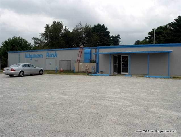
4600 N Smith St
84-02-36-453-005.000-013
Englewood Sub
Bowlingalley
ENGLEWOOD SUB ALSO 1/2 VAC ALLEY & ST ADJ D-416/142 & 966-967 36-13-9 LOTS 461-464
X
Vigo
18121C0350C
Indiana
2024
461-464
2024
0.81 AC
010100
Other Market Areas
16,290 SF
Terre Haute, IN
DEMOGRAPHICS near 4600 N Smith St
1 Mile
3 Mile
5 Mile
2024 Total Population
2,187
18,029
54,810
2029 Population
2,176
17,936
54,932
Pop Growth 2024-2029
(0.50%)
(0.52%)
+ 0.22%
Average Age
39
40
38
2024 Total Households
824
7,197
21,602
HH Growth 2024-2029
(0.61%)
(0.67%)
+ 0.19%
Median Household Inc
$43,124
$45,048
$43,063
Avg Household Size
2.40
2.30
2.30
2024 Avg HH Vehicles
2.00
2.00
2.00
Median Home Value
$97,259
$105,609
$118,784
Median Year Built
1969
1962
1962
Nearby Places
Map Layers
Map Styles
 Street
 Aerial
- Restaurants
- Banks
- Shops
- Fitness
- Groceries
Nearby Properties
Address
Land Use
TOTAL SIZE
Lot Size
Zoning
Address
Land Use
TOTAL SIZE
Lot Size
Zoning
10,187 SF
12.39 AC
Address
Land Use
TOTAL SIZE
Lot Size
Zoning
13,934 SF
60.08 AC
Address
Land Use
TOTAL SIZE
Lot Size
Zoning
9,456 SF
12.39 AC
Address
Land Use
TOTAL SIZE
Lot Size
Zoning
311,785 SF
8 AC
Address
Land Use
TOTAL SIZE
Lot Size
Zoning
25,872 SF
120.83 AC
Address
Land Use
TOTAL SIZE
Lot Size
Zoning
160,350 SF
16.74 AC
Address
Land Use
TOTAL SIZE
Lot Size
Zoning
190,248 SF
9.60 AC
Address
Land Use
TOTAL SIZE
Lot Size
Zoning
498,185 SF
12 AC
Address
Land Use
TOTAL SIZE
Lot Size
Zoning
380,096 SF
21.77 AC
Address
Land Use
TOTAL SIZE
Lot Size
Zoning
265,008 SF
29.30 AC
Address
Land Use
TOTAL SIZE
Lot Size
Zoning
197,800 SF
11.45 AC
Address
Land Use
TOTAL SIZE
Lot Size
Zoning
415,768 SF
41.63 AC
Address
Land Use
TOTAL SIZE
Lot Size
Zoning
21,939 SF
9.29 AC
Address
Land Use
TOTAL SIZE
Lot Size
Zoning
351,613 SF
14.98 AC
Address
Land Use
TOTAL SIZE
Lot Size
Zoning
202,386 SF
57.14 AC
Address
Land Use
TOTAL SIZE
Lot Size
Zoning
82,485 SF
13.06 AC
Address
Land Use
TOTAL SIZE
Lot Size
Zoning
117,253 SF
4.74 AC
Address
Land Use
TOTAL SIZE
Lot Size
Zoning
34,268 SF
2.60 AC
Address
Land Use
TOTAL SIZE
Lot Size
Zoning
61,950 SF
2.66 AC
Address
Land Use
TOTAL SIZE
Lot Size
Zoning
54,701 SF
1.37 AC
Address
Land Use
TOTAL SIZE
Lot Size
Zoning
1,056 SF
102.30 AC
Address
Land Use
TOTAL SIZE
Lot Size
Zoning
93,536 SF
69.75 AC
Address
Land Use
TOTAL SIZE
Lot Size
Zoning
100,800 SF
9.20 AC
Address
Land Use
TOTAL SIZE
Lot Size
Zoning
100,800 SF
6.53 AC
Address
Land Use
TOTAL SIZE
Lot Size
Zoning
35,362 SF
2.40 AC
Address
Land Use
TOTAL SIZE
Lot Size
Zoning
100,246 SF
9.20 AC
Address
Land Use
TOTAL SIZE
Lot Size
Zoning
12,680 SF
7.77 AC
Address
Land Use
TOTAL SIZE
Lot Size
Zoning
7,154 SF
1.91 AC
Address
Land Use
TOTAL SIZE
Lot Size
Zoning
103,783 SF
8.25 AC
Address
Land Use
TOTAL SIZE
Lot Size
Zoning
120,000 SF
14.49 AC
The World's #1 Commercial Real Estate Marketplace
Connect with us
© 2026 CoStar Group
The information above has been obtained from sources believed reliable. While we do not doubt its accuracy we have not verified it and make no guarantee, warranty or representation about it. It is your responsibility to independently confirm its accuracy and completeness. Any projections, opinions, assumptions, or estimates used are for example only and do not represent the current or future performance of the property. The value of this transaction to you depends on tax and other factors which should be evaluated by your tax, financial, and legal advisors. You and your advisors should conduct a careful, independent investigation of the property to determine to your satisfaction the suitability of the property for your needs.