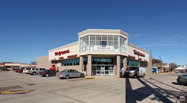
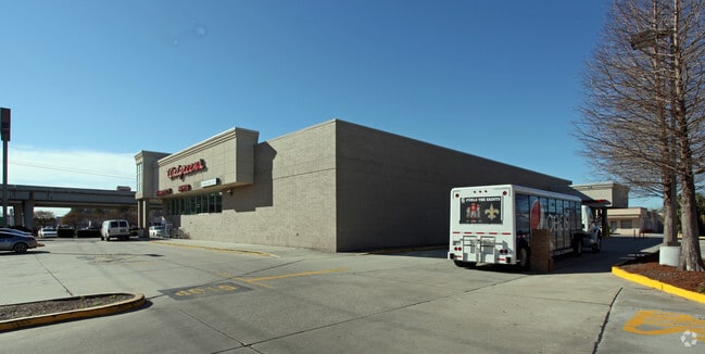
Property Record
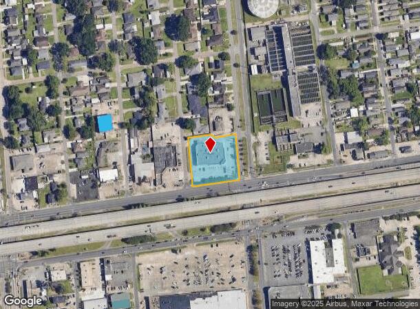
4600 Westbank Expy, Marrero, LA 70072
NEARBY LISTINGS FOR SALE OR LEASE
Property Detail
4600 Westbank Expy
New Orleans-Metairie, LA
Getzinger Sub & Add
0410001099
LOT WG-1A SQ KK GETZINGER
Realpropertynec
Jefferson
AE
Louisiana
22051C0215F
wg-1a
2024
1.26 AC
2024
Outer Jefferson Parish
026600
New Orleans/Metairie/Kenner
DEMOGRAPHICS near 4600 Westbank Expy
1 Mile
3 Mile
5 Mile
2024 Total Population
9,588
115,872
288,125
2029 Population
9,185
111,502
278,314
Pop Growth 2024-2029
(4.20%)
(3.77%)
(3.41%)
Average Age
45
41
40
2024 Total Households
4,311
49,526
120,053
HH Growth 2024-2029
(4.36%)
(3.92%)
(3.35%)
Median Household Inc
$43,552
$57,240
$54,048
Avg Household Size
2.20
2.30
2.30
2024 Avg HH Vehicles
2.00
1.00
1.00
Median Home Value
$167,540
$235,558
$232,858
Median Year Built
1963
1962
1965
Nearby Places
Map Layers
Map Styles
 Street
 Aerial
- Restaurants
- Banks
- Shops
- Fitness
- Groceries
PUBLIC TRANSPORTATION
COMMUTER RAIL
New Orleans Union Passenger Terminal (City of New Orleans - Amtrak, Crescent - Amtrak, Sunset Limited - Amtrak)
DRIVE
WALK
Distance
New Orleans Union Passenger Terminal (City of New Orleans - Amtrak, Crescent - Amtrak, Sunset Limited - Amtrak)
12 min
7.9 mi
AIRPORT
Louis Armstrong New Orleans International
DRIVE
WALK
Distance
Louis Armstrong New Orleans International
30 min
22.3 mi
Freight Ports
Port of New Orleans
DRIVE
WALK
Distance
Port of New Orleans
17 min
8.6 mi
Nearby Properties
Address
Land Use
TOTAL SIZE
Lot Size
Zoning
Address
Land Use
TOTAL SIZE
Lot Size
Zoning
468,704 SF
7.58 AC
MC
Address
Land Use
TOTAL SIZE
Lot Size
Zoning
3.66 AC
MC
Address
Land Use
TOTAL SIZE
Lot Size
Zoning
197,182 SF
0.01 AC
OS-R
Address
Land Use
TOTAL SIZE
Lot Size
Zoning
Address
Land Use
TOTAL SIZE
Lot Size
Zoning
10.42 AC
Address
Land Use
TOTAL SIZE
Lot Size
Zoning
0.14 AC
Address
Land Use
TOTAL SIZE
Lot Size
Zoning
4.12 AC
Address
Land Use
TOTAL SIZE
Lot Size
Zoning
151,320 SF
27.55 AC
Address
Land Use
TOTAL SIZE
Lot Size
Zoning
1.15 AC
Address
Land Use
TOTAL SIZE
Lot Size
Zoning
9.02 AC
HU-RD2
Address
Land Use
TOTAL SIZE
Lot Size
Zoning
7,468 SF
8.13 AC
HU-RD2
Address
Land Use
TOTAL SIZE
Lot Size
Zoning
1.27 AC
HU-RM1
Address
Land Use
TOTAL SIZE
Lot Size
Zoning
0.17 AC
Address
Land Use
TOTAL SIZE
Lot Size
Zoning
4.12 AC
HU-MU
Address
Land Use
TOTAL SIZE
Lot Size
Zoning
2.09 AC
HU-RD2
Address
Land Use
TOTAL SIZE
Lot Size
Zoning
3.46 AC
HU-RD2
Address
Land Use
TOTAL SIZE
Lot Size
Zoning
298,450 SF
17.22 AC
MC
Address
Land Use
TOTAL SIZE
Lot Size
Zoning
3.55 AC
Address
Land Use
TOTAL SIZE
Lot Size
Zoning
12.79 AC
Address
Land Use
TOTAL SIZE
Lot Size
Zoning
14.69 AC
Address
Land Use
TOTAL SIZE
Lot Size
Zoning
0.16 AC
Address
Land Use
TOTAL SIZE
Lot Size
Zoning
0.14 AC
Address
Land Use
TOTAL SIZE
Lot Size
Zoning
5.06 AC
HU-RS
Address
Land Use
TOTAL SIZE
Lot Size
Zoning
96,477 SF
1.73 AC
HU-RD2
Address
Land Use
TOTAL SIZE
Lot Size
Zoning
5,024 SF
12.62 AC
HU-RD2
Address
Land Use
TOTAL SIZE
Lot Size
Zoning
21.96 AC
MUCD
Address
Land Use
TOTAL SIZE
Lot Size
Zoning
Address
Land Use
TOTAL SIZE
Lot Size
Zoning
120,357 SF
7.88 AC
C-2
Address
Land Use
TOTAL SIZE
Lot Size
Zoning
0.78 AC
Address
Land Use
TOTAL SIZE
Lot Size
Zoning
0.14 AC
The World's #1 Commercial Real Estate Marketplace
Connect with us
© 2025 CoStar Group
The information above has been obtained from sources believed reliable. While we do not doubt its accuracy we have not verified it and make no guarantee, warranty or representation about it. It is your responsibility to independently confirm its accuracy and completeness. Any projections, opinions, assumptions, or estimates used are for example only and do not represent the current or future performance of the property. The value of this transaction to you depends on tax and other factors which should be evaluated by your tax, financial, and legal advisors. You and your advisors should conduct a careful, independent investigation of the property to determine to your satisfaction the suitability of the property for your needs.