Property Record
4601 Beloit Dr, Sacramento, CA 95838


Save to a Folder
{{folder.Name}}
{{folder.ListingIds.length}} Properties
{{folder.ListingIds.length}} Property
Create a New Folder
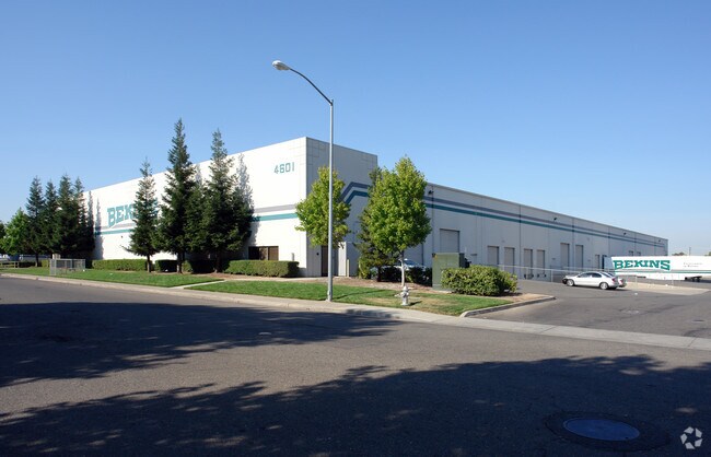
Property Detail
4601 Beloit Dr
238-0220-030
PARCEL MAP, LOT 2
Shipyard
Sacramento
M-1S-R
California
B and X Area of moderate flood hazard, usually the area between the limits of the 100-year and 500-year floods.
2
2025
4.04 AC
2026
McClellan
006400
Sacramento
71,035 SF
Sacramento-Roseville-Folsom, CA
NEARBY LISTINGS FOR SALE OR LEASE
DEMOGRAPHICS near 4601 Beloit Dr
1 mile
3 mile
5 mile
2025 Total Population
7,296
96,724
331,070
2030 Population
7,450
97,809
334,779
Pop Growth 2025-2030
+ 2.11%
+ 1.12%
+ 1.12%
Average Age
36
36
38
2025 Total Households
2,118
30,747
115,488
HH Growth 2025-2030
+ 2.22%
+ 1.11%
+ 1.15%
Median Household Inc
$69,858
$58,493
$74,215
Avg Household Size
3.30
3.00
2.80
2025 Avg HH Vehicles
2.00
2.00
2.00
Median Home Value
$380,817
$399,776
$445,997
Median Year Built
1982
1969
1974
Nearby Places
Map Layers
Map Styles
 Street
 Aerial
Layers
 Traffic
 Biking
Places
Listings with unknown addresses are not visible on the map
- Restaurants
- Banks
- Shops
- Fitness
- Groceries
PUBLIC TRANSPORTATION
COMMUTER RAIL
Drive
Walk
Distance
14 min
7.2 mi
AIRPORT
Sacramento International
Drive
Walk
Distance
Sacramento International
21 min
13.3 mi
Nearby Properties
Address
Land Use
TOTAL SIZE
Lot Size
Zoning
Address
Land Use
TOTAL SIZE
Lot Size
Zoning
224,595 SF
42.03 AC
SPA
Address
Land Use
TOTAL SIZE
Lot Size
Zoning
43,200 SF
38.55 AC
SPA
Address
Land Use
TOTAL SIZE
Lot Size
Zoning
152,000 SF
12.88 AC
SPA
Address
Land Use
TOTAL SIZE
Lot Size
Zoning
417,214 SF
23.66 AC
SPA
Address
Land Use
TOTAL SIZE
Lot Size
Zoning
15.83 AC
MRD-SPD
Address
Land Use
TOTAL SIZE
Lot Size
Zoning
263,792 SF
7.27 AC
SPA
Address
Land Use
TOTAL SIZE
Lot Size
Zoning
170,556 SF
8.41 AC
SPA
Address
Land Use
TOTAL SIZE
Lot Size
Zoning
1,221,441 SF
36.86 AC
SPA
Address
Land Use
TOTAL SIZE
Lot Size
Zoning
106,700 SF
5.38 AC
RD-30
Address
Land Use
TOTAL SIZE
Lot Size
Zoning
136,483 SF
3.77 AC
BP
Address
Land Use
TOTAL SIZE
Lot Size
Zoning
108,400 SF
5.51 AC
M-1S-R
Address
Land Use
TOTAL SIZE
Lot Size
Zoning
123,622 SF
5.93 AC
RD-20
Address
Land Use
TOTAL SIZE
Lot Size
Zoning
148,576 SF
4.84 AC
RD-30
Address
Land Use
TOTAL SIZE
Lot Size
Zoning
9.81 AC
SPA
Address
Land Use
TOTAL SIZE
Lot Size
Zoning
Address
Land Use
TOTAL SIZE
Lot Size
Zoning
81,538 SF
17.65 AC
A
Address
Land Use
TOTAL SIZE
Lot Size
Zoning
33,355 SF
2.76 AC
H
Address
Land Use
TOTAL SIZE
Lot Size
Zoning
117,288 SF
6.14 AC
M-1S-R
Address
Land Use
TOTAL SIZE
Lot Size
Zoning
100,462 SF
5.02 AC
RD-30
Address
Land Use
TOTAL SIZE
Lot Size
Zoning
164,000 SF
8.32 AC
SPA
Address
Land Use
TOTAL SIZE
Lot Size
Zoning
89,613 SF
4.48 AC
SPA
Address
Land Use
TOTAL SIZE
Lot Size
Zoning
2.76 AC
SPA
Address
Land Use
TOTAL SIZE
Lot Size
Zoning
140,400 SF
10.91 AC
MP
Address
Land Use
TOTAL SIZE
Lot Size
Zoning
158,315 SF
7.59 AC
M-1-PUD
Address
Land Use
TOTAL SIZE
Lot Size
Zoning
116,926 SF
7.23 AC
SPA
Address
Land Use
TOTAL SIZE
Lot Size
Zoning
171,021 SF
13 AC
M-1
Address
Land Use
TOTAL SIZE
Lot Size
Zoning
73,342 SF
4.88 AC
C-4-PUD
Address
Land Use
TOTAL SIZE
Lot Size
Zoning
56,668 SF
4.01 AC
SPA
Address
Land Use
TOTAL SIZE
Lot Size
Zoning
90,112 SF
4.44 AC
RD-30
Address
Land Use
TOTAL SIZE
Lot Size
Zoning
576,506 SF
21.22 AC
SPA
The World's #1 Commercial Real Estate Marketplace
Connect with us
© 2026 CoStar Group
The information above has been obtained from sources believed reliable. While we do not doubt its accuracy we have not verified it and make no guarantee, warranty or representation about it. It is your responsibility to independently confirm its accuracy and completeness. Any projections, opinions, assumptions, or estimates used are for example only and do not represent the current or future performance of the property. The value of this transaction to you depends on tax and other factors which should be evaluated by your tax, financial, and legal advisors. You and your advisors should conduct a careful, independent investigation of the property to determine to your satisfaction the suitability of the property for your needs.