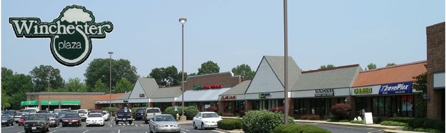
Property Record
4608 N Illinois St, Fairview Heights, IL 62208
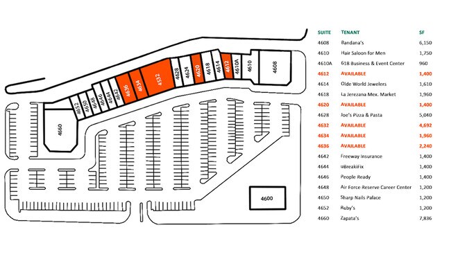
Current Lease Availabilities
General Retail LEASE
$14.50 SF/YR
1,400 - 4,692 SF
NEARBY LISTINGS FOR SALE OR LEASE
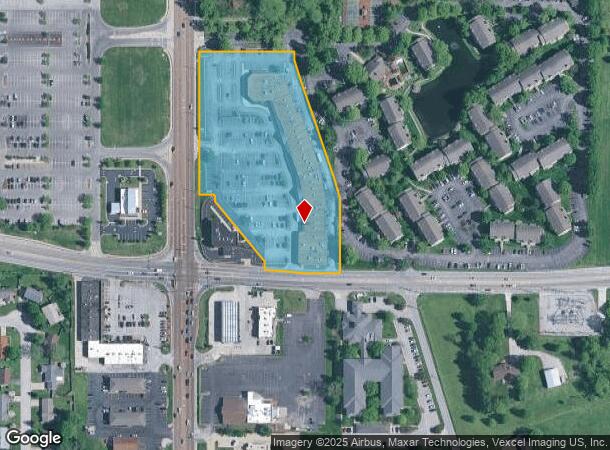
Property Detail
4608 N Illinois St
St. Louis, MO-IL
Caseyville Twp Sec 34
03-34.0-300-041
CASEYVILLE TWP SEC 34 LOT/SEC-34-SUBL/TWP-2N-BLK/RG-8W S 165 FT W 290 FT SW & PT A02780289 EX PT FOR RD AS A02544347
Commercialnec
St. Clair
2024
Illinois
2024
5.22 AC
503413
Metro East Illinois
46,610 SF
St. Louis
DEMOGRAPHICS near 4608 N Illinois St
1 Mile
3 Mile
5 Mile
2024 Total Population
6,693
46,001
124,926
2029 Population
6,337
44,225
120,956
Pop Growth 2024-2029
(5.32%)
(3.86%)
(3.18%)
Average Age
42
41
41
2024 Total Households
2,790
19,628
52,207
HH Growth 2024-2029
(5.34%)
(3.86%)
(3.17%)
Median Household Inc
$83,519
$77,160
$74,457
Avg Household Size
2.30
2.30
2.30
2024 Avg HH Vehicles
2.00
2.00
2.00
Median Home Value
$191,455
$183,893
$167,502
Median Year Built
1989
1986
1976
Nearby Places
- Restaurants
- Banks
- Shops
- Fitness
- Groceries
PUBLIC TRANSPORTATION
COMMUTER RAIL
Memorial Hospital (Lambert Airport Shiloh-Scott - St. Louis MetroLink (MetroLink))
DRIVE
WALK
Distance
Memorial Hospital (Lambert Airport Shiloh-Scott - St. Louis MetroLink (MetroLink))
4 min
2.3 mi
Swansea (Lambert Airport Shiloh-Scott - St. Louis MetroLink (MetroLink))
DRIVE
WALK
Distance
Swansea (Lambert Airport Shiloh-Scott - St. Louis MetroLink (MetroLink))
5 min
2.7 mi
AIRPORT
Scott AFB/Midamerica St Louis
DRIVE
WALK
Distance
Scott AFB/Midamerica St Louis
24 min
10.3 mi
St Louis Lambert International
DRIVE
WALK
Distance
St Louis Lambert International
39 min
27.6 mi
Freight Ports
Port Milwaukee
DRIVE
WALK
Distance
Port Milwaukee
414 min
364.5 mi
Nearby Properties
Address
Land Use
TOTAL SIZE
Lot Size
Zoning
Address
Land Use
TOTAL SIZE
Lot Size
Zoning
Address
Land Use
TOTAL SIZE
Lot Size
Zoning
21.84 AC
Address
Land Use
TOTAL SIZE
Lot Size
Zoning
Address
Land Use
TOTAL SIZE
Lot Size
Zoning
9,384 SF
15.93 AC
Address
Land Use
TOTAL SIZE
Lot Size
Zoning
2,484 SF
16.76 AC
Address
Land Use
TOTAL SIZE
Lot Size
Zoning
13,440 SF
14.07 AC
Address
Land Use
TOTAL SIZE
Lot Size
Zoning
2,937 SF
16.68 AC
Address
Land Use
TOTAL SIZE
Lot Size
Zoning
Address
Land Use
TOTAL SIZE
Lot Size
Zoning
17,676 SF
3.09 AC
Address
Land Use
TOTAL SIZE
Lot Size
Zoning
207,910 SF
13.42 AC
Address
Land Use
TOTAL SIZE
Lot Size
Zoning
30.86 AC
Address
Land Use
TOTAL SIZE
Lot Size
Zoning
143,464 SF
10.78 AC
Address
Land Use
TOTAL SIZE
Lot Size
Zoning
Address
Land Use
TOTAL SIZE
Lot Size
Zoning
167,235 SF
18.91 AC
Address
Land Use
TOTAL SIZE
Lot Size
Zoning
6,172 SF
7.31 AC
Address
Land Use
TOTAL SIZE
Lot Size
Zoning
3.24 AC
Address
Land Use
TOTAL SIZE
Lot Size
Zoning
5,772 SF
11.48 AC
Address
Land Use
TOTAL SIZE
Lot Size
Zoning
29,906 SF
4.24 AC
Address
Land Use
TOTAL SIZE
Lot Size
Zoning
41,366 SF
12.07 AC
Address
Land Use
TOTAL SIZE
Lot Size
Zoning
140,850 SF
16.71 AC
Address
Land Use
TOTAL SIZE
Lot Size
Zoning
142,369 SF
12.01 AC
Address
Land Use
TOTAL SIZE
Lot Size
Zoning
1,863 SF
11.46 AC
Address
Land Use
TOTAL SIZE
Lot Size
Zoning
127,251 SF
12.15 AC
Address
Land Use
TOTAL SIZE
Lot Size
Zoning
Address
Land Use
TOTAL SIZE
Lot Size
Zoning
1.94 AC
Address
Land Use
TOTAL SIZE
Lot Size
Zoning
7,004 SF
9.59 AC
Address
Land Use
TOTAL SIZE
Lot Size
Zoning
7.82 AC
Address
Land Use
TOTAL SIZE
Lot Size
Zoning
74,479 SF
5.96 AC
Address
Land Use
TOTAL SIZE
Lot Size
Zoning
15,888 SF
20.30 AC
Address
Land Use
TOTAL SIZE
Lot Size
Zoning
The World's #1 Commercial Real Estate Marketplace
Connect with us
© 2025 CoStar Group
The information above has been obtained from sources believed reliable. While we do not doubt its accuracy we have not verified it and make no guarantee, warranty or representation about it. It is your responsibility to independently confirm its accuracy and completeness. Any projections, opinions, assumptions, or estimates used are for example only and do not represent the current or future performance of the property. The value of this transaction to you depends on tax and other factors which should be evaluated by your tax, financial, and legal advisors. You and your advisors should conduct a careful, independent investigation of the property to determine to your satisfaction the suitability of the property for your needs.